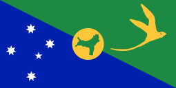
Outline of Christmas Island
The emblem of the Shire of Christmas Island

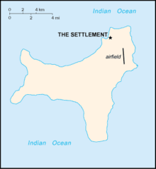
The location of Christmas Island
An enlargeable relief map of the Australian Territory of Christmas Island
Christmas Island is a small territory of Australia located in the Indian Ocean, 2600 kilometres (1600 mi) northwest of Perth in Western Australia, 500 kilometres (300 mi) south of Jakarta, Indonesia, and 975 km ENE of the Cocos (Keeling) Islands.[1] Christmas Island supports about 1,600 residents, who live in a number of "settlement areas" on the northern tip of the island: Flying Fish Cove (also known as Kampong), Silver City, Poon Saan and Drumsite.
General reference
An enlargeable basic map of Christmas Island
- Pronunciation:
- Common English country name: Christmas Island
- Official English country name: The Australian Territory of Christmas Island
- Common endonym(s):
- Official endonym(s):
- Adjectival(s): Christmas Island
- Demonym(s):
- Etymology: Name of Christmas Island
- ISO country codes: CX, CXR, 162
- ISO region codes: See ISO 3166-2:CX
- Internet country code top-level domain: .cx
Geography of Christmas Island

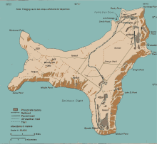
An enlargeable topographic map of Christmas Island
Main article: Geography of Christmas Island
- Christmas Island is: an island and territory of Australia
- Location:
- Northern Hemisphere and Eastern Hemisphere
- Eurasia (though not on the mainland)
- Time zone: UTC+07
- Extreme points of Christmas Island
- High: Murray Hill 361 m (1,184 ft)
- Low: Indian Ocean 0 m
- Land boundaries: none
- Coastline: 138.9 km
- Population of Christmas Island:
- Area of Christmas Island: 135 km2
- Atlas of Christmas Island
Environment of Christmas Island
- Climate of Christmas Island
- Environmental issues on Christmas Island
- Renewable energy in Christmas Island
- Geology of Christmas Island
- Protected areas of Christmas Island
- Biosphere reserves in Christmas Island
- National parks of Christmas Island
- Wildlife of Christmas Island
- Fauna of Christmas Island
Natural geographic features of Christmas Island
- Fjords of Christmas Island
- Glaciers of Christmas Island
- Islands of Christmas Island
- Lakes of Christmas Island
- Mountains of Christmas Island
- Volcanoes in Christmas Island
- Rivers of Christmas Island
- Waterfalls of Christmas Island
- Valleys of Christmas Island
- World Heritage Sites in Christmas Island: None
Regions of Christmas Island
Administrative divisions of Christmas Island
None
Municipalities of Christmas Island
- Capital of Christmas Island: Flying Fish Cove
- Cities of Christmas Island
Demography of Christmas Island
Demographics of Christmas Island
Government and politics of Christmas Island
- Main article: Government of Christmas Island
- Form of government: local government area
- Capital of Christmas Island: Flying Fish Cove
- Elections in Christmas Island
Branches of government
Main article: Government of Christmas Island
Foreign relations of Christmas Island
Main article: Foreign relations of Australia
International organization membership
- none [1]
Law and order in Christmas Island
History of Christmas Island
Main article: History of Christmas Island
- Military history of Christmas Island
Culture of Christmas Island
- Architecture of Christmas Island
- Cuisine of Christmas Island
- Festivals in Christmas Island
- Languages of Christmas Island
- Media in Christmas Island
- National symbols of Christmas Island
- People of Christmas Island
- Public holidays in Christmas Island
- Records of Christmas Island
- Religion in Christmas Island
- Christianity in Christmas Island
- Hinduism in Christmas Island
- Islam in Christmas Island
- Judaism in Christmas Island
- Sikhism in Christmas Island
- World Heritage Sites in Christmas Island: None
Art in Christmas Island
- Art in Christmas Island
- Cinema of Christmas Island
- Literature of Christmas Island
- Music of Christmas Island
- Television in Christmas Island
- Theatre in Christmas Island
Economy and infrastructure of Christmas Island
- Economic rank, by nominal GDP (2007):
- Internet in Christmas Island
- Companies of Christmas Island
- Currency of Christmas Island: Dollar
- Energy in Christmas Island
- Energy policy of Christmas Island
- Oil industry in Christmas Island
- Mining in Christmas Island
- Tourism in Christmas Island
- Transport in Christmas Island
Infrastructure of Christmas Island
- Health care in Christmas Island
- Transportation in Christmas Island
- Airports in Christmas Island
- Rail transport in Christmas Island
- Roads in Christmas Island
See also
| English language edition of Wikipedia, the free encyclopedia |
Main article: Christmas Island
- All pages beginning with "Christmas Island"
- All pages with titles containing Christmas Island
- Index of Christmas Island-related articles
- List of Christmas Island-related topics
- List of international rankings
- Outline of Asia
- Outline of Australia
- Outline of geography
References
- 1 2 "Christmas Island". The World Factbook. United States Central Intelligence Agency. July 2, 2009. Retrieved July 23, 2009.
External links
![]() Wikimedia Atlas of Christmas Island
Wikimedia Atlas of Christmas Island
- Christmas Island Shire - official government website
- Christmas Island Tourism Association - official tourism website
- Christmas Island Act 1958
-
 Christmas Island travel guide from Wikivoyage
 - Christmas Island at DMOZ
- "Christmas Island". The World Factbook. Central Intelligence Agency.
- Christmas Island Travel Guide from Unearth Travel a creative commons travel wiki
This article is issued from Wikipedia - version of the 9/16/2016. The text is available under the Creative Commons Attribution/Share Alike but additional terms may apply for the media files.