Outline of Ascension Island

The following outline is provided as an overview of and topical guide to Ascension Island:
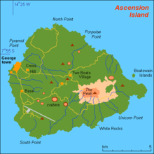
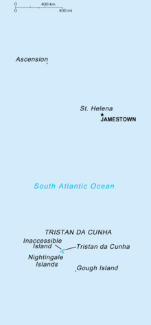
Ascension Island – island in the South Atlantic Ocean, around 966 miles (1,600 km) from the coast of Africa. It is part of the British overseas territory of Saint Helena, Ascension and Tristan da Cunha; Saint Helena itself is 800 miles (1,287 km) to the south east.[1] The Island is named after the day of its recorded discovery, Ascension Day. It is located at 7.56° S, 14.25° W.
The island is the location of Wideawake Airfield, which is a joint facility of the Royal Air Force and the United States Air Force.
General reference
- Pronunciation:
- Common English country name: Ascension Island
- Official English country name: Ascension Island
- Common endonym(s):
- Official endonym(s):
- Adjectival(s)
- Demonym(s)
- Etymology: Name of Ascension Island
- ISO region code: SH-AC
- Internet country code top-level domain: .ac
Geography
- Ascension Island is: an island, and a part of the British overseas territory of Saint Helena, Ascension and Tristan da Cunha
- Location: 7.56° S, 14.25° W
- Western Hemisphere and Southern Hemisphere
- Atlantic Ocean
- South Atlantic (east of Brazil, midway between South America and Africa)
- Time zone: Greenwich Mean Time (UTC+00)
- Extreme points of Ascension Island
- High: Green Mountain 859 m (2,818 ft)
- Low: South Atlantic Ocean 0 m
- Land boundaries: none
- Coastline: South Atlantic Ocean
- Population of Ascension Island: 1,100
- Area of Ascension Island: 91 square kilometres (35 sq mi) - 222nd largest country
- Atlas of Ascension Island
Environment

- Climate of Ascension Island
- Environmental issues on Ascension Island
- Renewable energy in Ascension Island
- Geology of Ascension Island
- Protected areas of Ascension Island
- Biosphere reserves in Ascension Island
- National parks of Ascension Island
- Wildlife of Ascension Island
- Fauna of Ascension Island
- Birds of Ascension Island
- Mammals of Ascension Island
- Fauna of Ascension Island
Natural geographic features of Ascension Island
- Fjords of Ascension Island
- Glaciers of Ascension Island
- Islands of Ascension Island
- Lakes of Ascension Island
- Mountains of Ascension Island
- Rivers of Ascension Island
- Waterfalls of Ascension Island
- Valleys of Ascension Island
- World Heritage Sites in Ascension Island: None
Regions
Regions of Ascension Island
Ecoregions
- Main article: Ecoregions in Ascension Island
Administrative divisions of Ascension Island
None.
Demography
Demographics of Ascension Island
Government and politics
- Main article: Government of Ascension Island and Ascension Island#Politics
- Form of government:
- Capital of Ascension Island: Georgetown
- Elections in Ascension Island
Branches of government
Executive branch
- Head of state: British monarch
- Head of government: Governor of Saint Helena, Ascension and Tristan da Cunha
Legislative branch
Judicial branch
Foreign relations
- Diplomatic missions in Ascension Island
- Diplomatic missions of Ascension Island
Law and order
- Constitution of Ascension Island
- Crime in Ascension Island
- Human rights in Ascension Island
- LGBT rights in Ascension Island
- Freedom of religion in Ascension Island
- Law enforcement in Ascension Island
Military
- Commander-in-Chief: Governor of Saint Helena, Ascension and Tristan da Cunha
- RAF Ascension Island (with US presence too)
History
- Main article: History of Ascension Island, Timeline of the history of Ascension Island, and Current events of Ascension Island
- Military history of Ascension Island
Culture
- Architecture of Ascension Island
- Cuisine of Ascension Island
- Festivals in Ascension Island
- Languages of Ascension Island
- Media in Ascension Island
- National symbols of Ascension Island
- People of Ascension Island
- Public holidays in Ascension Island
- Records of Ascension Island
- Religion in Ascension Island
- Christianity in Ascension Island
- Hinduism in Ascension Island
- Islam in Ascension Island
- Judaism in Ascension Island
- Sikhism in Ascension Island
- World Heritage Sites in Ascension Island: None
Art in Ascension Island
- Art in Ascension Island
- Cinema of Ascension Island
- Literature of Ascension Island
- Music of Ascension Island
- Television in Ascension Island
- Theatre in Ascension Island
Sports in Ascension Island
Sports in Ascension Island
- Football in Ascension Island
- Ascension Island at the Olympics
Economy and infrastructure of Ascension Island
- Economic rank, by nominal GDP (2007):
- Agriculture in Ascension Island
- Banking in Ascension Island
- National Bank of Ascension Island
- Communications in Ascension Island
- Internet in Ascension Island
- Companies of Ascension Island
- Currency of Ascension Island: Pound
- Energy in Ascension Island
- Energy in Ascension Island
- Energy policy of Ascension Island
- Oil industry in Ascension Island
- Health care in Ascension Island
- Mining in Ascension Island
- Tourism in Ascension Island
- Transport in Ascension Island
- Airports in Ascension Island
- Rail transport in Ascension Island
- Roads in Ascension Island
Education in Ascension Island
Education in Ascension Island
See also
| English language edition of Wikipedia, the free encyclopedia |
- All pages beginning with "Ascension Island"
- All pages beginning with "Ascension Islander"
- All pages with titles containing Ascension Island
- All pages with titles containing Ascension Islander
- Index of Ascension Island-related articles
- List of Ascension Island-related topics
- List of international rankings
- Outline of Africa
- Outline of geography
- Outline of Saint Helena
- Outline of the United Kingdom
References
- ↑ "Saint Helena". The World Factbook. United States Central Intelligence Agency. July 3, 2009. Retrieved July 23, 2009.
External links
![]() Wikimedia Atlas of Ascension Island
Wikimedia Atlas of Ascension Island
- Ascension Island Newspaper
- Ascension Island Government
- Rocket launches from Ascension
- CIA World Factbook entry about Saint Helena
- Live Web Cam of Ascension
- Cable and Wireless
- Colonial History of Ascension Island