Urtijëi
| Urtijëi | |
|---|---|
| Comune | |
| Chemun de Urtijëi Gemeinde St. Ulrich Comune di Ortisei | |
 | |
 Urtijëi Location of Urtijëi in Italy | |
| Coordinates: 46°34′N 11°40′E / 46.567°N 11.667°ECoordinates: 46°34′N 11°40′E / 46.567°N 11.667°E | |
| Country | Italy |
| Region | Trentino-Alto Adige/Südtirol |
| Province / Metropolitan city | South Tyrol (BZ) |
| Government | |
| • Mayor | Tobia Moroder |
| Area | |
| • Total | 24.3 km2 (9.4 sq mi) |
| Elevation | 1,230 m (4,040 ft) |
| Population (31 January 2015)[1] | |
| • Total | 4,753 |
| • Density | 200/km2 (510/sq mi) |
| Demonym(s) |
Italian: gardenesi German: Sankt Ulricher |
| Time zone | CET (UTC+1) |
| • Summer (DST) | CEST (UTC+2) |
| Postal code | 39046 |
| Dialing code | 0471 |
| Patron saint | San Udalricus |
| Saint day | July 4 |
| Website | Official website |
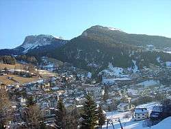
Urtijëi (![]() [uʀtiˈʒɜi̯] ; German: St. Ulrich in Gröden [saŋkt ˈulrɪç in ˈɡrøːdn̩]; Italian: Ortisei [ortiˈzɛi]) is a town of 4,637 inhabitants in South Tyrol in northern Italy. It occupies the Val Gardena within the Dolomites, a mountain chain that is part of the Alps.
[uʀtiˈʒɜi̯] ; German: St. Ulrich in Gröden [saŋkt ˈulrɪç in ˈɡrøːdn̩]; Italian: Ortisei [ortiˈzɛi]) is a town of 4,637 inhabitants in South Tyrol in northern Italy. It occupies the Val Gardena within the Dolomites, a mountain chain that is part of the Alps.
Geography
Urtijëi borders the following municipalities: Kastelruth, Villnöß, Lajen and Santa Cristina Gherdëina.
History
The Ladin-language name Urtijëi derives from the Latin word urtica and the suffix -etum with the meaning "place of nettles".[2]
From 1860 to 1914 Urtijëi experienced a relevant economical growth due to the opening of a major road connecting Val Gardena to the main railroad; as a result the local woodcarving industry flourished. International tourism developed through the discovery of the Dolomites first by English tourists, and subsequently visitors from other parts of Austria-Hungary as well as the German Empire. Currently, the town's economy is mostly based on winter skiing tourism, summer hiking tourism, and woodcarving.
Coat of arms
The emblem shows Saint Ulrich, with the bishop's vestments and an or cross in his right hand, mounted on a horse, with or harness, on three vert mountains on or. The emblem is decorated with an azure chief, with three small shields alternating with two or bees; the bees symbolize the laboriousness of the inhabitants. The coat of arms was granted in 1907 and reappointed in 1970.[3]
Main sights

- Museum Gherdëina, the local heritage museum.
- Parish Church of Urtijëi.
Society
According to the 2011 census, 84.19% of the population speaks Ladin, 9.30% German and 6.51% Italian as first language.[4]
People
- Carolina Kostner
- Giorgio Moroder
- Isolde Kostner
- Josef Moroder-Lusenberg
- Ernesto Prinoth
- Luis Trenker
References
- ↑ All demographics and other statistics from the Italian statistical institute (Istat)
- ↑ Kühebacher, Egon (1991), Die Ortsnamen Südtirols und ihre Geschichte. Die geschichtlich gewachsenen Namen der Gemeinden, Fraktionen und Weiler, 1, Bolzano: Athesia, p. 502
- ↑ Heraldry of the World: Urtijëi
- ↑ "Volkszählung 2011/Censimento della popolazione 2011". astat info. Provincial Statistics Institute of the Autonomous Province of South Tyrol (38): 6–7. June 2012. Retrieved 2012-06-14.
External links
| Wikivoyage has a travel guide for Ortisei. |
![]() Media related to Urtijëi at Wikimedia Commons
Media related to Urtijëi at Wikimedia Commons
- Official website (Italian) (Ladin) (German)
- Museum Gherdëina - Local heritage museum
