Onekotan
| Native name: <span class="nickname" ">Онекотан 温禰古丹島 | |
|---|---|
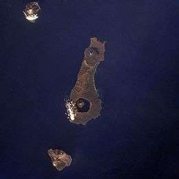 Onekotan Island (centre) from space, October 1994. North at top | |
 | |
| Geography | |
| Location | Sea of Okhotsk |
| Coordinates | 49°27′N 154°46′E / 49.450°N 154.767°ECoordinates: 49°27′N 154°46′E / 49.450°N 154.767°E |
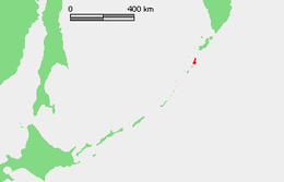
| Archipelago | Kuril Islands |
| Area | 425 km2 (164 sq mi) |
| Highest elevation | 1,325 m (4,347 ft) |
| Highest point | Krenitsyn |
| Administration | |
|
Russia | |
| Demographics | |
| Population | 0 |
| Ethnic groups | Ainu (formerly) |
Onekotan Island (Russian: Онекотан; Japanese 温禰古丹島; Onekotan-tō, occasionally Onnekotan-tō, Ainu: オネコタン or オネコタㇴ) is an uninhabited volcanic island located near the northern end of the Kuril Islands chain in the Sea of Okhotsk in the northwest Pacific Ocean. Its name is derived from the Ainu language for "large village".
Geography and geology
Onekotan is roughly rectangular, with a length of 42.5 kilometers, and a width ranging from 11 kilometers to 17 kilometers. It has an area of 425 km² [1]
The island consists of two stratovolcanos connected by a relatively flat isthmus.
- Krenitsyn -(Russian: Креницын ; Japanese 黒石山; Kuroishiyama) with a height of 1,325 meters is the prominent caldera at the southern end of the island. This volcano was named after Captain Pyotr Krenitsyn of the Imperial Russian Navy.[2] The mountain rises from a depth of from 600 to 900 meters, and contains a deep central caldera lake, called Tao-Rusyr Caldera. The central peak of this "island within the island" is actually the highest point on Onekotan Island
- Nemo -(Russian: влк Палласа; Japanese 根茂山; Nemoyama) with a height of 1,019 meters is the peak to the north. It has two nested subsidiary calderas, with the cone of Nemo Peak rising in the southwest end of the youngest caldera and a crescent-shaped crater lake partially filling the northeast part.
Onekotan Island is separated from the neighboring islands by the Fourth Kuril Strait, Yevreinov Strait, and Krenitsyn Strait. The neighboring islands are Makanrushi Island, with a 1170 meters volcanic peak, to the northwest of Onekotan Island; and Kharimkotan Island, with a 1210 meter high volcano, to the south.
Onekotan still has an active volcano with the most recent eruption, in 1952, forming a small lava dome on the island's coast.
- Onekotan
 Mount Krenitsyn on Onekotan Island
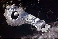 Snow cover highlights the calderas and volcanic cones that form the northern and southern ends of Onekotan.
History
Onekotan, with a number of shallow bays and sandy beaching providing landing points, was inhabited by the Ainu prior to European contact. It appears on an official map showing the territories of Matsumae Domain, a feudal domain of Edo period Japan dated 1644, and these holdings were officially confirmed by the Tokugawa shogunate in 1715. Subsequently, claimed by the Empire of Russia, sovereignty initially passed to Russia under the terms of the Treaty of Shimoda, but was returned to the Empire of Japan per the Treaty of Saint Petersburg in 1875 along with the rest of the Kuril islands. The island was formerly administered as part of Shimushu District of Nemuro Subprefecture of Hokkaidō. After World War II, the island came under the control of the Soviet Union, and is now administered as part of the Sakhalin Oblast of the Russian Federation.
Fauna
There are chars in Lake Chyornoye, one of the two lakes on Onekotan, located at the northern end of the island. In the spring and summer pigeon guillemot and Leach's storm petrel nest on the island.[3]
See also
Notes
- ↑ "International Kuril Island Project(IKIP)". University of Washington Fish Collection or the respective authors.
- ↑ "Global Volcanism Program". Smithsonian National Museum of Natural History.
- ↑ Kondratyev, A. Y., Litvinenko, N. M., Shibaev, Y. V., Vyatkin, P. S., & Kondratyeva, L. F. (2000). "The breeding seabirds of the Russian Far East". Seabirds of the Russian Far East, 37-81.
References
Further reading
- Gorshkov, G. S. Volcanism and the Upper Mantle Investigations in the Kurile Island Arc. Monographs in geoscience. New York: Plenum Press, 1970. ISBN 0-306-30407-4
- Krasheninnikov, Stepan Petrovich, and James Greive. The History of Kamtschatka and the Kurilski Islands, with the Countries Adjacent. Chicago: Quadrangle Books, 1963.
- Rees, David (1985). The Soviet Seizure of the Kuriles. Praeger Publishers. ISBN 0-03-002552-4.
- Takahashi, Hideki, and Masahiro Ōhara. Biodiversity and Biogeography of the Kuril Islands and Sakhalin. Bulletin of the Hokkaido University Museum, no. 2-. Sapporo, Japan: Hokkaido University Museum, 2004.
External links
| Wikimedia Commons has media related to Onekotan. |