Oklahoma Panhandle
| Oklahoma Panhandle | |||||
| |||||
| |||||
 | |||||
| Capital | Beaver City 36°48′N 100°31′W / 36.800°N 100.517°WCoordinates: 36°48′N 100°31′W / 36.800°N 100.517°W | ||||
| Government | Provisional, unelected, unrecognized[1] | ||||
| President | |||||
| • | 1886–1887 | Owen G Chase | |||
| History | |||||
| • | Texas Republic founded; includes Panhandle area | March 2, 1836 | |||
| • | Texas Republic surrenders claim; Panhandle becomes "unattached" territory | 1850 | |||
| • | First petition for territorial status sent to Congress | February 1887 | |||
| • | Second petition for territorial status sent to Congress | December 1887 | |||
| • | Attached to Oklahoma Territory | 1890 | |||
The Oklahoma Panhandle is the extreme northwestern region of the state of Oklahoma, consisting of Cimarron County, Texas County, and Beaver County, from west to east. Its name comes from the similarity of its shape to the handle of a cooking pan.
The three-county Oklahoma Panhandle region had a population of 28,751 at the 2010 census, representing 0.77% of the state's population. This is a decrease in total population of 1.2%, a loss of 361 people, from the census of 2000.
Geography

The Panhandle, 166 miles (267 km) long and 34 miles (55 km) wide, is bordered by Kansas and Colorado at 37°N on the north, New Mexico at 103°W on the west, Texas at 36.5°N on the south, and the remainder of Oklahoma at 100°W on the east. The largest town in the region is Guymon, which is the county seat of Texas County. Black Mesa, the highest point in Oklahoma at 4,973 feet (1,516 m), is located in Cimarron County. The Panhandle occupies nearly all of the true High Plains within the state of Oklahoma, being the only part of the state lying west of the 100th meridian, which generally marks the westernmost extent of moist air from the Gulf of Mexico. The North Canadian River is named Beaver River or Beaver Creek on its course through the Panhandle. Its land area is 5,686 square miles (14,730 km2), which is larger than that of the state of Connecticut, and comprises 8.28 percent of Oklahoma's land area.[2]
The area also includes Beaver Dunes State Park with sand dunes along the Beaver River and Optima Lake, the home of the Optima National Wildlife Refuge.
History
Prior to the arrival of European explorers,[3] the panhandle was home to the Panhandle culture from 1200 to 1400 CE. This Plains culture included the Antelope Creek Phase (1200–1500 CE).[4] They were semi-sedentary, living in large, stone-slab and plaster houses in villages or individual homesteads. As horticulturalists, they farmed maize. Several Antelope Phase sites were founded near present-day Guymon, Oklahoma, including the McGrath Site, Stamper Site, and Two Sisters Site.[4] With the arrival of horses from Spain in the 16th century, American Indian tribes increased their hunting ranges.
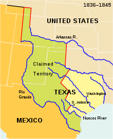
The Western history of the Panhandle traces its origins as being part of the Spanish New Spain empire. The Transcontinental Treaty (Adams-Onís Treaty) of 1819 between Spain and the United States set the western boundary of this portion of the Louisiana Purchase at the 100th meridian. With Mexican independence in 1821, these lands became part of Mexico. With the formation of the Texas Republic, they became part of Texas. When Texas joined the U.S. in 1846, the strip became part of the United States.[5]
The Cimarron Cutoff for the Santa Fe Trail passed through the area soon after the trade route was established in 1826 between the Spanish in Santa Fe and the Americans in St. Louis. The route was increasingly used during the California Gold Rush. The Cutoff passed several miles north of what are now Boise City, Oklahoma and Clayton, New Mexico before continuing toward Santa Fe.[6]
When Texas sought to enter the Union in 1845 as a slave state, federal law in the United States, based on the Missouri Compromise, prohibited slavery north of 36°30' parallel north. Under the Compromise of 1850, Texas surrendered its lands north of 36°30' latitude. The 170-mile strip of land, a "neutral strip", was left with no state or territorial ownership from 1850 until 1890. It was officially called the "Public Land Strip" and was commonly referred to as "No Man's Land."[7][8]
The Compromise of 1850 also established the eastern boundary of New Mexico Territory at the 103rd meridian, thus setting the western boundary of the strip. The Kansas-Nebraska Act of 1854 set the southern border of Kansas Territory as the 37th parallel. This became the northern boundary of No Man's Land. When Kansas joined the Union in 1861, the western part of Kansas Territory was assigned to Colorado Territory, but did not change the boundary.[8]
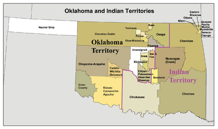
Cimarron Territory
After the Civil War, cattlemen moved into the area. Gradually they organized themselves into ranches and established their own rules for arranging their land and adjudicating their disputes. There was still confusion over the status of the strip and some attempts were made to arrange rent with the Cherokees, despite the fact that the Cherokee Outlet ended at the 100th meridian. In 1885, the U. S. Supreme Court ruled that the strip was not part of the Cherokee Outlet.[9] In 1886, Interior Secretary L. Q. C. Lamar, declared the area to be public domain and subject to "squatter's rights".[10]
The strip was not yet surveyed, and as that was one of the requirements of the Homestead Act of 1862, the land could not be officially settled. Settlers by the thousands flooded in to assert their "squatter's rights" anyway. They surveyed their own land and by September 1886 had organized a self-governing and self-policing jurisdiction, which they named the Cimarron Territory. Representative Daniel W. Voorhees of Indiana introduced a bill in Congress to attach the so-called territory to Kansas. It passed both the Senate and the House of Representatives but was not signed by President Grover Cleveland.[9]
The organization of Cimarron Territory began soon after Lamar declared the area open to settlement by squatters. The settlers formed their own vigilance committees, which organized a board charged with forming a territorial government. The board enacted a preliminary code of law and divided the strip into three districts. They also called for a general election to choose three members from each district to meet on March 4, 1887, to form a government.[11]
The elected council met as planned, elected Owen G. Chase as president, and named a full cabinet. They also enacted further laws and divided the strip into five counties (Benton, Beaver, Palo Duro, Optima, and Sunset), three senatorial districts (with three members from each district), and seven delegate districts (with two members from each district). The members from these districts were to be the legislative body for the proposed territory. Elections were held November 8, 1887, and the legislature met for the first time on December 5, 1887.[9]
After the meeting in March, Owen G. Chase went to Washington, D.C. to lobby for admission to Congress as the delegate from the new territory. He was not recognized by Congress.[12] A group disputing the Chase organization met, and elected and sent its own delegate to Washington.[13] A bill was introduced to accept Chase but was never brought to a vote. Neither delegation was able to persuade Congress to accept the new territory.[10] Another delegation went in 1888 but was also unsuccessful.[12]
Settlement and assimilation
In 1889, the Unassigned Lands were opened for settlement and many of the residents went there. The population was generously estimated by Owen Chase at 10,000 after the opening. Ten years later, an actual count revealed only 2,548.[14] The passage of the Organic Act in 1890 assigned No Man's Land to the new Oklahoma Territory, and ended the short-lived Cimarron Territory aspirations.[12]

In 1891, the government completed the survey and the remaining squatters were finally able to secure their homesteads under the Homestead Act. The new owners were then able to obtain mortgages against their property, enabling them to buy seed and equipment. Capital and new settlers came into the area and the first railroad, the Rock Island, built a line through the county from Liberal, Kansas to Dalhart, Texas. Agriculture began changing from subsistence farms to grain exporters.[8]
No Man's Land became Seventh County under the newly organized Oklahoma Territory, and was soon renamed Beaver County. Beaver City became the county seat. When Oklahoma Territory and Indian Territory joined the Union in 1907 as the single state of Oklahoma, Beaver County was divided into the present Beaver, Texas, and Cimarron counties. The Oklahoma Panhandle had the highest population it has ever recorded at its first census, more than double its current population.[15]
Dust Bowl
The Panhandle was the part of Oklahoma that was most adversely impacted by the drought of the 1930s. The drought began in 1932 and created massive dust storms. By 1935, the area was widely known as the Dust Bowl. The dust storms were largely a result of poor farming techniques and a plow-up of the native grasses that held the fine soil in place. Despite government efforts to implement conservation measures and change the basic farming methods of the region, the Dust Bowl persisted for nearly a decade. It was claimed to have contributed significantly to the length of the Great Depression in the United States.[16] The U. S. census showed that each of the three counties experienced a major loss of population during the decade 1930–1940.
Demographics
As of the 2010 census, there were a total of 28,751 people, 10,451 households, and 7,466 families in the three counties that comprise the Oklahoma Panhandle.[17] The racial makeup of the region was 80.26% white including persons of mixed race, 59.46% non-Hispanic white, 1.34% African American, 1.21% Native American, 1.18% Asian, 0.12% Pacific Islander, 15.53% from other races, and 2.78% from two or more races.[17] Hispanic and Latino Americans made up 35.85% of the population.[17]
As of the 2000 census, 7.7% of the population was under the age of five, and 12.5% of the population exceeded 65 years of age. Of the population under the age of 5, 54.95% were non-Hispanic white, 41.12% were Hispanic of any race, and 0.80% were African American alone. Of the population 65 years of age and over, 95.29% were non-Hispanic white, 3.52% were Hispanic, and 0.03% was African American. Of the non-Hispanic white population, 16.45% were 65 years of age or older.
As of the 1990 census, 89.40% of the population was non-Hispanic White, 9.11% were of Hispanic of any race, and 0.27% were African American. 6.72% of the population was under 5 years of age, and 14.7% were 65 years of age or older.
The median income for a household in the region was $34,404, and the median income for a family was $40,006. Males had a median income of $27,444 versus $19,559 for females. The per capita income for the region was $16,447.
Cities and towns
Major communities
- Beaver (County Seat of Beaver County)
- Boise City (County Seat of Cimarron County)
- Goodwell (Home to Oklahoma Panhandle State University)
- Guymon (County Seat of Texas County and largest city in the Oklahoma Panhandle)
- Hooker
- Texhoma
Other communities
Economy
The Panhandle is rather thinly populated (when compared to the rest of Oklahoma) making the labor force in this region very small. Farming and ranching operations occupy most of the economic activity in the region, with ranching dominating the drier western end. The region's higher educational needs are served by Oklahoma Panhandle State University in Goodwell, 10 miles southwest of Guymon, the Panhandle's largest city.[18]
Politics
The Oklahoma Panhandle is one of the most universally Republican areas of the United States. None of the three counties in the region have supported a Democrat for president since 1976.
In the 2008 U.S. Presidential election, the three counties gave a weighted average of 87.5% of their votes to John McCain and 12.5% to Barack Obama, with McCain carrying the state over Obama 65.6% to 34.4%.[19] Also, in 2006 the Oklahoma Panhandle counties were the only three where the majority voted against the successful Democratic incumbent, Governor Brad Henry.
In 2012, Democratic voters in the Panhandle voted for Randall Terry, a Pro-Life activist, over incumbent Democrat Barack Obama in the Democratic Presidential primary. Terry had not earned enough ballot spots in the state primaries to win the Democratic nomination, rendering votes for him to effectively be protest votes.
Points of interest
- Black Mesa State Park features a hiking trail to the top of Oklahoma's highest point
- Beaver Dunes State Park features massive sand dunes along the Beaver River – located just north of the town of Beaver
- Optima Lake is home to the Optima National Wildlife Refuge
In popular culture
- Edna Ferber wrote the novel Cimarron, which was published in 1929.
- A 1931 RKO Radio Pictures film version of Ferber's novel, Cimarron, won the Academy Award for Best Picture.
- Badman's Territory (1946) was a movie that starred Randolph Scott as a Texas sheriff in the Panhandle, out of his jurisdiction, where he meets such famous outlaws as Jesse James, Frank James, the Dalton Gang, and Belle Starr. The story was fictional to such an extent that it claimed the region was a haven for such outlaws and that the citizens wanted it to stay that way. The thriving town was called "Quinto".
- The 1931 picture was remade in 1960 by MGM, Cimarron, directed by Anthony Mann.
- Cimarron Strip was a United States television series based loosely on the Cimarron Territory. It was produced by CBS, running only one season (23 episodes), debuting on September 7, 1967 and ending on September 19, 1968.
- Spirit: Stallion of the Cimarron is an animated film, released in 2002, and set in the region during the post-Civil War era.
- That Old Ace in the Hole is a 2002 novel by Annie Proulx (of Brokeback Mountain fame) set in the Texas and Oklahoma Panhandles.
Notes and references
Notes
- ↑ Richter, Sara and Tom Lewis. "Cimarron Territory," Encyclopedia of Oklahoma History and Culture, Oklahoma Historical Society, Accessed July 1, 2015.
- ↑ NetState.com
- ↑ "African Explorers of Spanish America". Park Ethnography Program. US National Park Service. Retrieved 13 April 2015.
- 1 2 Lintz, Christopher. "Antelope Creek Phase". Texas State Historical Association. Retrieved 17 March 2015.
- ↑ Gibson, Arrell M. Oklahoma: A History of Five Centuries. Retrieved May 11, 2013. Available on Google Books.
- ↑ Map of the Santa Fe Trail. Retrieved February 14, 2015.
- ↑ "Oklahoma Panhandle: Badmen in No Man's Land". Wild West magazine. 2006-06-12. Retrieved 2012-11-30.
- 1 2 3 Turner, Kenneth R. "No Man's Land". Encyclopedia of Oklahoma History and Culture. Oklahoma Historical Society. Retrieved 2012-11-30.
- 1 2 3 Sara Richter and Tom Lewis, "Cimarron Territory", Encyclopedia of Oklahoma History and Culture. Accessed April 13, 2013.
- 1 2 Wardell, p. 83
- ↑ Wardell, p. 84
- 1 2 3 "Beaver County – No Man's Land". Annual Reports of the Department of the Interior for the Fiscal Year Ended June 30, 1904. U.S. Department of the Interior. 1904. pp. 463–465. Retrieved November 30, 2012.
- ↑ Wardell, p. 86
- ↑ Wardell, p. 885
- ↑ Cimarron: Concept of Panhandle State Nixed by Political Squabbling, Cotton Boll Conspiracy, November 4, 2015
- ↑ Library of Congress. "America's Story from America's Library: The Dust Bowl of Oklahoma." Retrieved July 30, 2013.
- 1 2 3 American FactFinder Archived September 11, 2013, at the Wayback Machine., United States Census Bureau. (accessed September 3, 2013)
- ↑ Goins, Charles Robert and Danney Goble. "The Oklahoma Panhandle, 2000." In: Historical Atlas of Oklahoma. Available on Google Books.p. 206. Retrieved January 19. 2014.
- ↑ US Election Atlas
References
- Beck, T.E. "Cimarron Territory," Chronicles of Oklahoma 7:2 (June 1929) 168–169 (retrieved August 16, 2006).
- Counties of the Oklahoma Panhandle United States Census Bureau
- Wardell, Morris L. "The History of No-Man's Land, or Old Beaver County", Chronicles of Oklahoma 1:1 (January 1921) 60–89 (retrieved August 16, 2006).
Further reading
- Christman, Harry E. (editor-original manuscript by Jim Herron). Fifty Years on the Owl Hoot Trail: The First Sheriff of No Man's Land, Oklahoma Territory. Sage Books: Chicago, 1969.
- Lowitt, Richard. American Outback: The Oklahoma Panhandle in the Twentieth Century (Texas Tech University Press, 2006) . xxii, 137 pp. ISBN 0-89672-558-8
External links
| Wikimedia Commons has media related to Oklahoma Panhandle. |
- Oklahoma article at HighBeam Encyclopedia.com
- Oklahoma Panhandle was formerly called Cimarron Territory
- Cimarron Council of the Boy Scouts of America
- Oklahoma History Center: Education Programs
- Encyclopedia of Oklahoma History and Culture – Cimarron Territory