Ohio State Route 822
| ||||
|---|---|---|---|---|
| University Boulevard[1] | ||||
|
Current route of SR 822 in solid red, former sections in dashed red | ||||
| Route information | ||||
| Maintained by ODOT | ||||
| Length: | 0.13 mi[2] (0.21 km) | |||
| Existed: | 1990 – present | |||
| Major junctions | ||||
| West end: | 7th Street in Steubenville | |||
|
| ||||
| East end: |
| |||
| Location | ||||
| Counties: | Jefferson | |||
| Highway system | ||||
| ||||

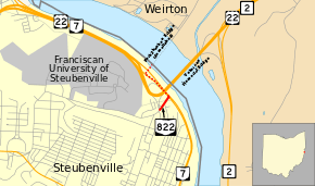
State Route 822 (SR 822) is an unsigned east–west state highway in the eastern portion of the U.S. state of Ohio. The short route was designated in 1990. Its western terminus is at the intersection of 7th Street and the on-/off-ramps for U.S. Route 22 (US 22), where it serves as a connection between the U.S. Route and SR 7, the route's eastern terminus. The whole route is in Steubenville, after multiple truncations due to the demolition of Fort Steuben Bridge.
Route description
SR 822 starts at 7th Street on University Boulevard, where it immediately meets US 22 east at an interchange with on-/off-ramps. SR 822 then passes through 6th Street, before ending at SR 7 at a T-intersection, which later becomes concurrent with US 22.[2][3]
Around 11,580 vehicles use the route on average each day.[4] The connector is part of the expanded National Highway System.[5] SR 822 has open fields and ramps north of it, and businesses south of it.
History
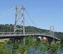
SR 822 was designated in 1990 as US 22's alignment was moved to the Veterans Memorial Bridge from Fort Steuben Bridge.[6][7][8][9] Traffic began to drop as the structure of the bridge deteriorated, and the weight limit was lowered in 2004.[10][11] The Fort Steuben Bridge was closed in 2009, a few years after plans of closure and demolition were announced.[11] It was closed due to deteriorating conditions and limited use.[10][12] The Ohio Department of Transportation (ODOT) created a temporary eastern terminus for the route at the north end of the SR 7/822 concurrency, where the bridge approach ramps began.[13] The eastern terminus was changed to the south end of the SR 7/822 concurrency in 2013.[2]
Major intersections
| County | Location | mi[2][14] | km | Destinations | Notes |
|---|---|---|---|---|---|
| Jefferson | Steubenville | 0.00 | 0.00 | 7th Street / University Boulevard | |
| 0.01– 0.06 | 0.016– 0.097 | Access to only US 22 eastbound, with on-/off-ramps; access westbound via SR 7 | |||
| 0.13 | 0.21 | Current eastern terminus | |||
| 0.27 | 0.43 | Eastern terminus from 2010–2013[2][13] | |||
| Ohio River | 0.39– 0.70 | 0.63– 1.13 | Fort Steuben Bridge | ||
| Brooke | Weirton | 0.70 | 1.13 | Freedom Way | Eastern terminus before bridge closure |
1.000 mi = 1.609 km; 1.000 km = 0.621 mi
| |||||
See also
-
 Ohio portal
 -
 U.S. Roads portal
References
- ↑ Ohio Department of Transportation. "Technical Services Functional Classification of State and Local Roads - District 11 - Jefferson County" (PDF). Retrieved October 21, 2013.
- 1 2 3 4 5 Ohio Department of Transportation. "Technical Services DESTAPE" (PDF). Retrieved October 20, 2013.
- ↑ Microsoft; Nokia (October 24, 2013). "Ohio State Route 822" (Map). Bing Maps. Microsoft. Retrieved October 24, 2013.
- ↑ Staff. "Transportation Information Mapping System". Ohio Department of Transportation. Retrieved October 22, 2013.
- ↑ Expanded National Highway System: Ohio - District 11 (PDF) (Map). Ohio Department of Transportation. Retrieved October 26, 2013.
- ↑ "Demolition of the Fort Steuben Bridge - Planning and Preliminary Study Report" (PDF). Ohio Department of Transportation. Retrieved November 14, 2013.
- ↑ Hicks, Ian (February 21, 2012). "Down in a Blaze of Glory: Fort Steuben Bridge is No More". The Intelligencer & Wheeling News Register. Retrieved October 23, 2013.
- ↑ Ohio State Map (Map). Ohio Department of Transportation. 1989. Retrieved October 23, 2013.
- ↑ Ohio State Map (Map). Ohio Department of Transportation. 1992. Retrieved October 23, 2013.
- 1 2 Scott, Warren (February 21, 2012). "Blast topples Fort Steuben Bridge". The Herald-Star. Retrieved October 23, 2013.
- 1 2 Scott, Warren (January 12, 2012). "Fort Steuben Bridge Demolition Begins". The Intelligencer & Wheeling News Register. Retrieved October 26, 2013.
- ↑ McCarty, Becky (January 15, 2009). "Fort Steuben Bridge Will Remain Closed" (Press release). Ohio Department of Transportation. Retrieved October 23, 2013.
- 1 2 Ohio Department of Transportation. "Traffic Survey Report, Jefferson County, 2010" (PDF). Retrieved February 22, 2012.
- ↑ Ohio Department of Transportation. "Technical Services Straight Line Diagrams" (PDF). Archived from the original (PDF) on August 19, 2014. Retrieved April 30, 2010.