Ohio City, Cleveland
| Ohio City | |
|---|---|
| Neighborhoods of Cleveland | |
|
Market Avenue, one of Ohio City's pedestrian-friendly streets | |
| Country | United States |
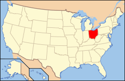
| State | Ohio |
| County | Cuyahoga County |
| City | Cleveland |
| Population (2010) | |
| • Total | 9,210 |
| 1.1% decrease from 2000 Census | |
| Demographics | |
| • White | 41.1% |
| • Black | 32.0% |
| • Hispanic | 22.9% |
| • Asian | 1.3% |
| • Mixed Race & Other | 2.2% |
| Time zone | EST (UTC-5) |
| • Summer (DST) | EDT (UTC-4) |
| ZIP Codes | 44113, 44102 |
| Area code(s) | 216 |
| Median income | $20,408 |
| Source: 2010 U.S. Census, City Planning Commission of Cleveland[1] | |

|
Ohio City Preservation District | |
|
The West Side Market | |
   | |
| Location | Roughly Franklin Blvd. NW., W. 38th St., Bridge Ave. NW., & W. 44th St., & Stone, W. 25th, Bridge Ave. NW., & W. 28th, Cleveland, Ohio |
|---|---|
| Coordinates | 41°29′1″N 81°42′37″W / 41.48361°N 81.71028°WCoordinates: 41°29′1″N 81°42′37″W / 41.48361°N 81.71028°W |
| Architect | Unknown |
| Architectural style | Greek Revival, Italianate, Queen Anne |
| NRHP Reference # | [2] |
| Added to NRHP | May 25, 1989 |
Ohio City is one of the oldest neighborhoods in Cleveland, Ohio. It is located immediately west of the Cuyahoga River.
History
The City of Ohio became an independent municipality on March 3, 1836, splitting from Brooklyn Township. The city grew from a population of 2,400 people in the early 1830s to over 4,000 in 1850. The municipality was annexed by Cleveland on June 5, 1854.
James A. Garfield, who became the 20th president of the United States, frequently preached at Franklin Circle Christian Church in 1857. Franklin Circle Christian Church is located at the intersection of Franklin Boulevard and Fulton Road.
The birthplace of John Heisman, famous for the annual Heisman Trophy awarded to the best player in college football, is located in Ohio City. He was born in the neighborhood in 1869, and an Ohio Historical Society marker stands in commemoration near the corner of Bridge Avenue and West 29th Place.[3]
Features
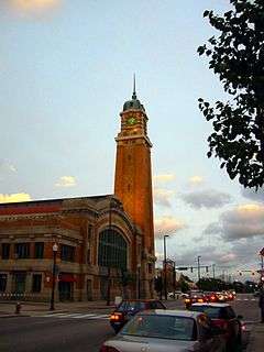
The salient feature of Ohio City's business district is the historic West Side Market, built in 1912. The European-styled market, located at the intersection of Lorain Avenue and West 25th Street, draws an estimated one million visitors annually.[4] Located north of the West Side Market is The Ohio City Fresh Food Collaborative, one of the largest contiguous urban farms in America. The operation includes a farm, retail farm stand and community kitchen on a 6-acre city parcel.[5]
Ohio City contains the largest concentration of craft breweries in Cleveland, which includes Market Garden Brewery, Nanobrew, Platform Beer and the state of Ohio's oldest microbrewery, the Great Lakes Brewing Company. (Both Market Garden and Great Lakes have fullscale brewpubs adjacent to the West Side Market), with the latter occupying a building that formerly housed the Market Tavern, a pub frequented by Eliot Ness.[6]
Saint Ignatius High School, a Jesuit college prep school, is located near the West Side Market. Founded in 1886, the school has a long list of distinguished graduates and is a perennial contender in several OHSAA sports. Members of the community have bristled at the expansion of the school and have resisted the sales of surrounding property.
The Cleveland Hostel, which opened in 2012, is the first and only hostel in the city of Cleveland.[7] The hostel is located on West 25th Street and Chatham Avenue adjacent to the W.25th Street Station on the RTA Red Line.
St. John's Episcopal Church, located at Church and West 26th Street, is the oldest consecrated building in Cuyahoga County and is the mother church of the current Episcopal cathedral located in downtown Cleveland. The church was one of the final stops on the Underground Railroad in Northeastern Ohio, and the remains of an entrance to a tunnel leading to the banks of the nearby Cuyahoga River can still be seen in the basement. Several nearby streets retain church-related names, such as Vestry. An Episcopal parish continues to worship in the space, although membership has dramatically declined with the demographic changes in the neighborhood.
Demographics
The demographics of Ohio City have changed rather dramatically in the latter half of the 20th century and first part of the 21st. Originally composed mainly of English and German descendants, many Eastern European immigrants moved into the area during the migrations in the first half of the 20th century. In the 1960s and 1970s, as Cleveland expanded and the wealthy moved to the surrounding suburbs (including Parma, Brooklyn, and Lakewood), the percentage of African Americans increased. The size of the Latino community has also increased. However, Cleveland City Council, with an eye on redevelopment and with the incentive of tax breaks, has lured an increasing number of suburbanites of all backgrounds back into the Ohio City area. This has led to a diverse community.
Gallery
 Looking down Ohio City's retail hub, West 25th.
 Ohio City's rapid transit station
 Saint Ignatius High School main building completed 1891
References
- ↑ "Census 2010 PL94-171 Redistricting Data for Cleveland's Statistical Planning Areas (Yr 2000 boundaries)" (PDF). Cleveland City Planning Commission. City of Cleveland. Retrieved April 3, 2013.
- ↑ National Park Service (2008-04-15). "National Register Information System". National Register of Historic Places. National Park Service.
- ↑ http://www.hmdb.org/marker.asp?marker=17908
- ↑ About at WestSideMarket.org
- ↑ http://ohiocityfarm.wordpress.com/
- ↑ Around the Brewpub at Great Lakes Brewing Company
- ↑ http://theclevelandhostel.com/
External links
41°29′03″N 81°42′41″W / 41.484195°N 81.711295°W
| Wikimedia Commons has media related to Ohio City. |

 |
Lake Erie | |
| |
| Detroit-Shoreway | |
Downtown Cleveland | ||
| ||||
| | ||||
| Clark-Fulton | Tremont |