Oelde
| Oelde | ||
|---|---|---|
|
Lange Street - Oelde centre | ||
| ||
 Oelde | ||
Location of Oelde within Warendorf district 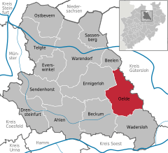
 | ||
| Coordinates: 51°50′N 8°9′E / 51.833°N 8.150°ECoordinates: 51°50′N 8°9′E / 51.833°N 8.150°E | ||
| Country | Germany | |
| State | North Rhine-Westphalia | |
| Admin. region | Münster | |
| District | Warendorf | |
| Government | ||
| • Mayor | Karl-Friedrich Knop (FW) | |
| Area | ||
| • Total | 102.63 km2 (39.63 sq mi) | |
| Population (2015-12-31)[1] | ||
| • Total | 29,299 | |
| • Density | 290/km2 (740/sq mi) | |
| Time zone | CET/CEST (UTC+1/+2) | |
| Postal codes | 59302 | |
| Dialling codes | 02522, 02529, 02520, 05245 | |
| Vehicle registration | WAF | |
| Website | www.oelde.de | |


Oelde (German pronunciation: [ˈœldə]; Westphalian: Üle) is a town in the district of Warendorf, in North Rhine-Westphalia, Germany. It is located near Beckum.
Geography
Division of the town

Oelde consists of 5 districts:
- Oelde
- Stromberg
- Lette
- Sünninghausen
- Kirchspiel (with farming communities)
- Keitlinghausen
- Ahmenhorst
- Menninghausen
Neighbouring places
International relations
Oelde is twinned with:
History
.JPG)
Records from the 9th century show that there was a settlement named "Ulidi" on the site, although Oelde only received township in the year 1800. In the 14th century, a castle was built in Oelde.
Economy
Oelde is a centre of metal and lumber production, publishing, and also higher education through its nursing college. It is also home to the headquarters of GEA ( Westfalia Separator), a manufacturer of centrifuges and dairy machines.
Transport
Roads
Oelde is connected to the Bundesautobahn 2.
Railways

The Hamm–Minden railway connects Oelde station to the German rail network. The line is served by the Westfalen-Express and the Ems-Börde-Bahn every hour.
References
- ↑ "Amtliche Bevölkerungszahlen". Landesbetrieb Information und Technik NRW (in German). 18 July 2016.
External links
- Official site (German)
Towns and municipalities in Warendorf (district) | ||
|---|---|---|