Oecusse District
| Oecusse Ambeno Oekusi-Ambenu | ||
|---|---|---|
| District | ||
|
A padrão in Lifau marks the spot where the Portuguese first landed on Timor in 1515. | ||
| ||
 Map of East Timor highlighting Oecusse District | ||
| Coordinates: 9°20′S 124°18′E / 9.333°S 124.300°ECoordinates: 9°20′S 124°18′E / 9.333°S 124.300°E | ||
| Country |
| |
| Capital | Pante Macassar | |
| Subdistricts | Nitibe, Oesilo, Passabe, Pante Macassar | |
| Area | ||
| • Total | 814 km2 (314 sq mi) | |
| Area rank | 8th | |
| Population (2015) | ||
| • Total | 72,230 | |
| • Rank | 6th | |
| • Density | 89/km2 (230/sq mi) | |
| • Density rank | 4th | |
| Households | ||
| • Total | 13,659 (as of 2004) | |
| • Rank | 6th | |
| Time zone | UTC+9 | |
| ISO 3166 code | TL-OE | |


Oecusse (Tetum: Oekusi-Ambenu, also variously Oecussi, Ocussi, Oekussi, Oekusi, Okusi, Oé-Cusse), formerly Ambeno and Oecussi-Ambeno, is a district of East Timor. It is a coastal exclave in the western part of the island of Timor, separated from the rest of East Timor by West Timor, which is part of the province of Nusa Tenggara Timur, Indonesia, and which surrounds Oecusse in all directions except the north, where it borders the Savu Sea. The capital of the district is Pante Macassar, also called Oecussi Town, or formerly, in Portuguese Timor, Vila Taveiro. Originally Ambeno was the name of the district and Oecussi (< Oe Kusi) its capital.[1]
Geography
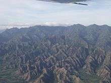
The district has an area of 814 km².
History
Oecusse and Ambeno are the names of the two original kingdoms, of which Ambeno existed before the colonial period.
Oecusse was among the first parts of the island of Timor on which the Portuguese established themselves, and is thus usually considered the cradle of East Timor. In about 1556, the Dominican friar António Taveiro, operating from a base on Solor, started missionary work on the north coast of Timor. Shortly after this, in 1569, the village of "Alifao" (Lifau) is mentioned on a European map. It was situated five kilometres to the west of modern Pante Macassar.[2] For the Portuguese traders in sandalwood, Lifau was a convenient place to land since it was situated to the south of their base in the Solor Archipelago. The area was dominated by the Ambeno kingdom, which was sometimes referred as the kingdom of Lifau. In 1641 the Dominican priests baptised the royal families of the Ambeno, Mena and Amanuban kingdoms, which meant that Portuguese influence increased in parts of western Timor. Migration of Topasses rose in the 1650s from Larantuka on Flores, a Eurasian population. After 1664 they were governed by officers belonging to the Hornay and Da Costa families, and were able to dominate most of Timor. The Topass leaders used Lifau as their main stronghold on Timor, but still resided much of their time in Larantuka. In the second half of the seventeenth century they made great profits through the sandalwood trade, attracting merchants from Siam, Batavia, Macao, and Goa in India. The precious wood was brought to Lifau and sold to external traders under Topass supervision.[3]
In 1702, Lifau became the authorised capital of the colony when it received the first governor from Goa. The following period saw frequent clashes between the governor and the independent-minded Topasses, who had their strongholds in Tulicão west of Lifau, and Animata in the inland. Under their leader Gaspar da Costa they attacked the Dutch colonial post at Kupang in 1749 but were smashingly defeated, and subsequently moved their residence to Pante Macassar (Oecusse) in 1759 due to Dutch military pressure. The capital of the governor was transferred from Lifau to Dili in 1769, because of the frequent attacks from the Topass leader Francisco Hornay III. Most of West Timor was left to Dutch forces, who were conquering what is today Indonesia. The Eurasian leadership of Oecusse by and by turned into a Timorese kingship, and members of the Hornay and Da Costa families reigned as Liurai (kings) until modern times. They regularly intermarried with the Ambeno royalty. In the 1780s a reconciliation took place between the governor in Dili and the Topasses, who henceforth usually supported the Portuguese government.[4]
In 1859, with the Treaty of Lisbon, Portugal and the Netherlands divided the island between them. West Timor became Dutch, with its colonial seat at Kupang, and East Timor became Portuguese, with its seat in Dili. This left Oecusse and Noimuti as enclaves surrounded by Dutch territory. In 1912 the Liurai of Ambeno, João da Cruz, staged a revolt against the Portuguese. It was quickly put down, after which the Ambeno kingdom lapsed. The Liurai of Oecusse became dominant in the entire Oecusse exclave.[5] The definitive border was drawn by the Hague in 1916. Apart from Japanese occupation during World War II, the border remained the same until the end of the colonial period. The region was given the status of county (conselho), named Oecússi, by the Portuguese government in August 1973, the last Timorese area to receive it.
Indonesian forces invaded Oecusse on 6 June 1975. In October they occupied the western border districts of East Timor's main territory. It was in Pante Macassar that an Indonesian fifth column raised the Indonesian flag on 29 November 1975, a week before the official Indonesian invasion of East Timor proper. However, even under Indonesian rule, Oecusse was administered as part of the province of East Timor, as it had been as part of Portuguese Timor. Like much of the country, it suffered violent attacks near the 1999 referendum for independence. Over 90 percent of the infrastructure was destroyed. It became part of the independent state of East Timor on 20 May 2002.
In the 1970s and 1980s, New Zealander anarchist Bruce Grenville began a hoax, claiming to have founded the sultanate of Occussi-Ambeno. He invented a history for the state of tribes united against the Portuguese, and produced many cinderella stamps for his creation.
On 11 November 1999, 600+ Australian troops from 3RAR (Third Battalion, Royal Australian Regiment) deployed from Maliana in East Timor proper to Oecusse to liberate the enclave. They stayed there until late February 2000, being replaced by Jordanian troops.
Climate
| Climate data for Oecusse (1919–1963) | |||||||||||||
|---|---|---|---|---|---|---|---|---|---|---|---|---|---|
| Month | Jan | Feb | Mar | Apr | May | Jun | Jul | Aug | Sep | Oct | Nov | Dec | Year |
| Record high °C (°F) | 32.3 (90.1) |
31.3 (88.3) |
33.4 (92.1) |
34.6 (94.3) |
34.8 (94.6) |
33.8 (92.8) |
33.2 (91.8) |
33.8 (92.8) |
34.7 (94.5) |
35.4 (95.7) |
33.6 (92.5) |
32.0 (89.6) |
35.4 (95.7) |
| Average high °C (°F) | 29.7 (85.5) |
29.3 (84.7) |
29.8 (85.6) |
30.4 (86.7) |
30.7 (87.3) |
30.3 (86.5) |
29.6 (85.3) |
29.1 (84.4) |
28.8 (83.8) |
29.4 (84.9) |
30.6 (87.1) |
30.3 (86.5) |
29.8 (85.6) |
| Daily mean °C (°F) | 27.3 (81.1) |
27.0 (80.6) |
27.2 (81) |
27.6 (81.7) |
27.7 (81.9) |
27.1 (80.8) |
26.2 (79.2) |
26.0 (78.8) |
26.3 (79.3) |
27.5 (81.5) |
28.4 (83.1) |
27.9 (82.2) |
27.2 (81) |
| Average low °C (°F) | 24.9 (76.8) |
23.6 (74.5) |
23.1 (73.6) |
22.8 (73) |
22.8 (73) |
22.0 (71.6) |
20.8 (69.4) |
20.4 (68.7) |
20.3 (68.5) |
22.0 (71.6) |
23.6 (74.5) |
23.8 (74.8) |
22.5 (72.5) |
| Record low °C (°F) | 20.5 (68.9) |
21.6 (70.9) |
19.0 (66.2) |
20.4 (68.7) |
18.5 (65.3) |
16.0 (60.8) |
15.6 (60.1) |
16.4 (61.5) |
17.0 (62.6) |
18.0 (64.4) |
20.9 (69.6) |
21.8 (71.2) |
15.6 (60.1) |
| Average precipitation mm (inches) | 282.0 (11.102) |
228.6 (9) |
205.5 (8.091) |
89.0 (3.504) |
36.6 (1.441) |
7.7 (0.303) |
6.2 (0.244) |
2.6 (0.102) |
1.3 (0.051) |
15.6 (0.614) |
54.2 (2.134) |
177.3 (6.98) |
1,106.6 (43.567) |
| Average precipitation days (≥ 0.1 mm) | 16 | 15 | 13 | 7 | 2 | 1 | 1 | 0 | 0 | 2 | 5 | 14 | 76 |
| Average relative humidity (%) | 78 | 78 | 76 | 74 | 68 | 63 | 65 | 67 | 71 | 76 | 75 | 77 | 72 |
| Mean monthly sunshine hours | 182.9 | 166.7 | 248.0 | 264.0 | 294.5 | 279.0 | 297.6 | 310.0 | 351.0 | 316.2 | 294.0 | 235.6 | 3,239.5 |
| Mean daily sunshine hours | 5.9 | 5.9 | 8.0 | 8.8 | 9.5 | 9.3 | 9.6 | 10.0 | 11.7 | 10.2 | 9.8 | 7.6 | 8.8 |
| Source: Deutscher Wetterdienst[6] | |||||||||||||
Administrative divisions


Oecusse is divided into four subdistricts:
- Nitibe Subdistrict
- Oesilo Subdistrict
- Pante Macassar Subdistrict (with capital Pante Macassar)
- Passabe Subdistrict
The subdistricts are divided into 18 sucos ("villages") in total.
Demographics
The district has a population of 58,521 people, divided into 13,016 households (Census 2004).
The Atoni, one of many indigenous ethnic groups, number about 20,000 in the district. A much larger number live in the surrounding part of West Timor.
Languages
The native language of most residents is Uab Meto (Meto), often referred to by outsiders as Baikeno. Portuguese is used in education and government, although despite its status as an official language there are few fluent speakers.
Although Indonesian was used as a lingua franca until 1999, since then it has been almost completely replaced in this role by Tetum which is the primary language of government, education and public life and is spoken and understood in all but very remote areas of the district.
Religion
99.3% of the inhabitants are Roman Catholic and 0.6% Protestant. There were 36 Hindus, 21 Muslims, 10 Animists and one Buddhist in 2010 census.
Transportation
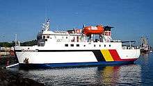
The ferry Berlin Nakroma connects the territory to Dili, arriving twice a week on a journey which takes 12 hours.
There is a grass airstrip at the edge of Pante Makassar.[7] In spite of regular rumours about a Timorese domestic airline beginning to operate, with the departure of the UN and its helicopters in December 2012 there are no regular air services to the district.
References
- ↑
- ↑ Frédéric Durand, Timor: 1250-2005, 750 ans de cartographie et de voyage. Toulouse: Arkuiris 2006, p. 65.
- ↑ Hans Hägerdal, 'Rebellions or factionalism? Timorese forms of resistance in an early colonial context, 1650-1769', Bijdragen tot de Taal-, Land- en Volkenkunde 163:1 2007, pp. 10-14.
- ↑ C.R. Boxer, The Topasses of Timor. Amsterdam: Indisch Instituut te Amsterdam 1947.
- ↑ R. Pelissier, Timor en guerre: Le crocodile et les portugais (1847-1913). Orgeval 1996, pp. 274-277, 299-301.
- ↑ "Klimatafel von Ocussi, Insel Timor / Ost-Timor" (PDF). Baseline climate means (1961-1990) from stations all over the world (in German). Deutscher Wetterdienst. Retrieved 29 January 2016.
- ↑ http://www.panoramio.com/photo/105804192
External links
| Wikimedia Commons has media related to Oecusse (Municipality). |
- Union of Capital Cities of the Portuguese Language (in Portuguese)
- Association of Soldiers of Oecusse (in Portuguese)
- La’o Hamutuk: Special Economic Zone in Oecusse (in Englisch & Tetum)
- Oecusse Enclave