Nyang'hwale District
| Nyang'hwale District | |
|---|---|
| District | |
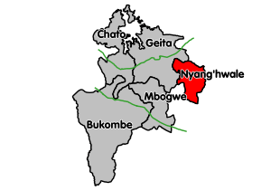 Nyang'hwale District's location within Geita Region. | |
| Coordinates: 03°12′S 032°39′E / 3.200°S 32.650°ECoordinates: 03°12′S 032°39′E / 3.200°S 32.650°E | |
| Country | Tanzania |
| Region | Geita Region |
| Population (2012) | |
| • Total | 148,320 |
Nyang'hwale District is one of the five districts of Geita Region of Tanzania. Its administrative centre is the village Kharumwa. It is bordered to the north by Sengerema District, to the east by Misungwi District and Shinyanga Rural District, to the south by Kahama Rural District, and to the west by Geita District.
As of 2012, the population of Nyang'hwale was 148,320.[1] Nyang'hwale was established in 2012, when it was split off from Geita District and became part of the newly established Geita Region.[2]
Transport
Nyang'hwale district is not connected by any paved or trunk roads. Two unpaved regional roads (R162 and R163) connect the district with Geita town, Kahama town and Sengerema District.[3]
Administrative subdivisions
Wards
As of 2012, Nyang'hwale District was administratively divided into 12 wards:[1]
|
|
|
References
- 1 2 "2012 Census". National Bureau of Statistics. Retrieved 1 December 2015.
- ↑ "Tanzania: New Regions, Districts Will Facilitate Service Provision". All Africa. Retrieved 1 December 2015.
- ↑ "Trunk and Regional Roads in Tanzania". Tanroads. Retrieved 1 December 2015.