Nuris
| Nuris | |
|---|---|
|
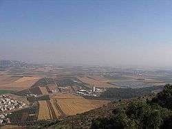
The Jezreel Valley today | |
 Nuris | |
| Arabic | نورِِِس |
| Also spelled | Noori[1] |
| Subdistrict | Jenin |
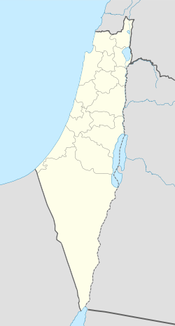
| Coordinates | 32°32′06.4″N 35°21′48.9″E / 32.535111°N 35.363583°ECoordinates: 32°32′06.4″N 35°21′48.9″E / 32.535111°N 35.363583°E |
| Palestine grid | 184/215 |
| Population | 570[2][3] (1945) |
| Area | 6256[2] dunams |
| Date of depopulation | May 29–30, 1948[4] |
| Cause(s) of depopulation | Military assault by Yishuv forces |
| Secondary cause | Fear of being caught up in the fighting |
| Current localities | Nurit[5] |
Nuris (Arabic: نورِِِس) was a Palestinian Arab village in the District of Jenin. In 1945, Nuris had 570 inhabitants. It was depopulated during the 1948 War on May 29, 1948 under Operation Gideon.[6]
Location
Nuris was located 9 kilometers (5.6 mi) northeast of Jenin, built on both sides of a shallow wadi. The Haifa-Beisan-Samakh railway-line passed northeast of the village. It was linked by dirt roads to the villages of Zir'in and Al-Mazar.[7]
There were several springs north of Nuris, most importantly 'Ayn Jalut (or Jalud), "Spring of Goliath", which was one of the largest springs in Palestine.[7]
History
Nuris was located in the Jezreel Valley and was referred to by the Crusaders as "Nurith." Nearby, the Mamluks decisively defeated the Mongols in the Battle of Ain Jalut in 1260.[7]
Ottoman era
In 1517, the village was included in the Ottoman Empire with the rest of Palestine, and in the 1596 tax-records it appeared part of the nahiya (subdistrict) of Jenin under the liwa' (district) of Lajjun, with a population of 88. It paid taxes on a number of products, including wheat, barley, olives, and goats and beehives.[8]
The village was captured and burned by Napoleon's troops, after the Battle of Mount Tabor in 1799.[9] Pierre Jacotin named the village Noures on his map from that campaign.[10]
In the early 19th-century, British traveller James Silk Buckingham noted that Nuris was surrounded by olive-trees.[1][7] Buckingham also remarked that there were several other settlements in sight, "all inhabited by Mohammedans."[1]
In 1882, the Palestine Exploration Fund's Survey of Western Palestine described the village as being small, situated on rocky ground, much hidden between the hills, about 600 ft (180 m) above a valley.[11] Nuris had an elementary school for boys, which was founded under the Ottomans in 1888, and a mosque.[7]
British Mandate era
In the 1922 census of Palestine, conducted by the British Mandate authorities, Nuris had a population of 364, all Muslims.[12] In 1921, the village reportedly had 38 tenant families, and 224 people out of a total population of 364 (1922 census) cultivated 5,500 dunums out of a village area of 27,018.[13] That year, the Sursock family sold some of the village lands to the Palestine Land Development Company. [14] A group of 35 young Jews began to farm the land, which became the core of Kibbutz Ein Harod. [15]
Some of the villagers of Nuris received monetary compensation and left the village.[13] Those who remained acquired a block of land for a period of six years and were given the opportunity to purchase the land originally leased to them. They paid rental at 6% of the published sale offer on the land, but later, at the request of the farmers in Nuris, this was changed to one-fifth of the total yield in agricultural output of the land.[13] After the original six-year lease was up, reports in 1928 showed that no villagers had bought the land leased to them.[13] In 1921 the average farmer cultivated 24 dunums, by 1929 this had drastically reduced to 4.4, although the population grew significantly.[16] In 1931, Nuris had a population of 429 people and a recorded 106 houses were located in the village.[17]
By 1945, Nuris had 570 inhabitants with 163 houses, although the area was much smaller than it had been before 1920, with an area of 6256 dunums. The inhabitants, were mainly employed in cereal farming, although some land was allocated to irrigation and growing olives.[2][7][18]
1948 War and aftermath
On 19 April 1948, Palmach headquarters ordered the destruction of "enemy bases at Al-Mazar, Nuris and Zir'in".[6] Israeli historian Benny Morris notes that destroying the villages was "part and parcel" of the Haganah operations at this time, however, he also writes that Nuris was not finally depopulated until the end of May.[4][6]
An Israeli moshav, Nurit, was later established on village land, northwest of the village site.[19] Palestinian historian Walid Khalidi described the village in 1992: "The site, overgrown with pine and oak trees, is strewn with piles of stones. Part of the surrounding land is fenced in and is used as a grazing area, while another part is cultivated. Cactuses and olive and fig trees grow near the site."[19]
References
- 1 2 3 Buckingham, 1821, p495
- 1 2 3 Government of Palestine, Department of Statistics. Village Statistics, April, 1945. Quoted in Hadawi, 1970, p. 55
- ↑ Department of Statistics, 1945, p. 16
- 1 2 According to Morris, 2004, p. xvii, village #123. Also gives causes of depopulation
- ↑ According to Morris, 2004, p. xxi, settlement #39, 1948
- 1 2 3 Morris, 2004, p. 346
- 1 2 3 4 5 6 Khalidi, 1992, p. 338
- ↑ Hütteroth and Abdulfattah, 1977, p. 161. Quoted in Khalidi, 1992, p. 338
- ↑ Cline, 2002, p. 161
- ↑ Karmon, 1960, p. 169
- ↑ Conder and Kitchener, 1882, SWP II, p.86. Also cited in Khalidi, 1992, p. 338
- ↑ Barron, 1923, Table IX, Sub-district of Jenin, p. 29
- 1 2 3 4 Stein, 1987, p.56
- ↑ Healing the Land and the Nation: Malaria and the Zionist Project in Palestine, 1920-1947, Sandra Sufian, p. 150
- ↑ Zeev Sternhell, 2009, The Founding Myths of Israel, p.198
- ↑ Stein, 1987, p.57
- ↑ Mills, 1932, p. 70
- ↑ Government of Palestine, Department of Statistics. Village Statistics, April, 1945. Quoted in Hadawi, 1970, p. 99
- 1 2 Khalidi, 1992, p. 339
Bibliography
- Barron, J. B., ed. (1923). Palestine: Report and General Abstracts of the Census of 1922. Government of Palestine.
- Buckingham, James Silk (1821). Travels in Palestine Through the Countries of Bashan and Gilead, East of the River Jordan, Including a Visit to the Cities of Geraza and Gamala in the Decapolis.
- Cline, Eric H. (2002): The Battles of Armageddon: Megiddo and the Jezreel Valley from the Bronze Age to the Nuclear Age
- Conder, Claude Reignier; Kitchener, H. H. (1882). The Survey of Western Palestine: Memoirs of the Topography, Orography, Hydrography, and Archaeology. 2. London: Committee of the Palestine Exploration Fund. p. 125
- Department of Statistics (1945). Village Statistics, April, 1945. Government of Palestine.
- Hadawi, Sami (1970). Village Statistics of 1945: A Classification of Land and Area ownership in Palestine. Palestine Liberation Organization Research Center.
- Hütteroth, Wolf-Dieter; Abdulfattah, Kamal (1977). Historical Geography of Palestine, Transjordan and Southern Syria in the Late 16th Century. Erlanger Geographische Arbeiten, Sonderband 5. Erlangen, Germany: Vorstand der Fränkischen Geographischen Gesellschaft. ISBN 3-920405-41-2.
- Karmon, Y. (1960). "An Analysis of Jacotin's Map of Palestine" (PDF). Israel Exploration Journal. 10 (3,4): 155–173; 244–253.
- Khalidi, Walid (1992). All That Remains: The Palestinian Villages Occupied and Depopulated by Israel in 1948. Washington D.C.: Institute for Palestine Studies. ISBN 0-88728-224-5. ISBN 0-88728-224-5.
- Mills, E., ed. (1932). Census of Palestine 1931. Population of Villages, Towns and Administrative Areas (PDF). Jerusalem: Government of Palestine.
- Morris, Benny (2004). The Birth of the Palestinian Refugee Problem Revisited. Cambridge University Press. ISBN 978-0-521-00967-6.
- Palmer, E. H. (1881). The Survey of Western Palestine: Arabic and English Name Lists Collected During the Survey by Lieutenants Conder and Kitchener, R. E. Transliterated and Explained by E.H. Palmer. Committee of the Palestine Exploration Fund. p.166
- Stein, Kenneth W. (1987). The Land Question in Palestine, 1917-1939. UNC Press. ISBN 0-8078-4178-1.
- Tepper, Yotam (2009-07-07). "Nuris" (121). Hadashot Arkheologiyot – Excavations and Surveys in Israel.
External links
- Welcome To Nuris
- Survey of Western Palestine, Map 9: IAA, Wikimedia commons
- Nuris at Khalil Sakakini Cultural Center