Nunez, Georgia
| Nunez, Georgia | |
|---|---|
| City | |
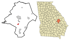 Location in Emanuel County and the state of Georgia | |
| Coordinates: 32°29′31″N 82°20′48″W / 32.49194°N 82.34667°WCoordinates: 32°29′31″N 82°20′48″W / 32.49194°N 82.34667°W | |
| Country | United States |
| State | Georgia |
| County | Emanuel |
| Area | |
| • Total | 1.34 sq mi (3.47 km2) |
| • Land | 1.32 sq mi (3.42 km2) |
| • Water | 0.02 sq mi (0.05 km2) |
| Elevation | 249 ft (76 m) |
| Population (2010) | |
| • Total | 147 |
| • Density | 111/sq mi (43.0/km2) |
| Time zone | Eastern (EST) (UTC-5) |
| • Summer (DST) | EDT (UTC-4) |
| ZIP code | 30448 |
| Area code(s) | 912 |
| FIPS code | 13-56644[1] |
| GNIS feature ID | 0319720[2] |
Nunez is a city in Emanuel County, Georgia, United States. The population was 147 at the 2010 census.[3]
Geography
Nunez is located in southern Emanuel County at 32°29′31″N 82°20′48″W / 32.49194°N 82.34667°W (32.491880, -82.346547).[4] Georgia State Route 297 passes through the city, leading north 8 miles (13 km) to Swainsboro, the county seat, and south 6 miles (10 km) to Interstate 16 Exit 84.
According to the U.S. Census Bureau, Nunez has a total area of 1.4 square miles (3.5 km2), of which 0.02 square miles (0.05 km2), or 1.52%, is water.[3]
Demographics
| Historical population | |||
|---|---|---|---|
| Census | Pop. | %± | |
| 1910 | 174 | — | |
| 1920 | 730 | 319.5% | |
| 1930 | 162 | −77.8% | |
| 1940 | 155 | −4.3% | |
| 1950 | 82 | −47.1% | |
| 1960 | 18 | −78.0% | |
| 1970 | 117 | 550.0% | |
| 1980 | 168 | 43.6% | |
| 1990 | 135 | −19.6% | |
| 2000 | 131 | −3.0% | |
| 2010 | 147 | 12.2% | |
| Est. 2015 | 149 | [5] | 1.4% |
As of the census[1] of 2000, there were 131 people, 50 households, and 36 families residing in the town. The population density was 97.7 people per square mile (37.7/km²). There were 53 housing units at an average density of 39.5 per square mile (15.3/km²). The racial makeup of the town was 69.47% White, 23.66% African American, 0.76% Asian, 6.11% from other races. Hispanic or Latino of any race were 6.11% of the population.
There were 50 households out of which 30.0% had children under the age of 18 living with them, 56.0% were married couples living together, 14.0% had a female householder with no husband present, and 28.0% were non-families. 26.0% of all households were made up of individuals and 10.0% had someone living alone who was 65 years of age or older. The average household size was 2.62 and the average family size was 3.22.
In the town the population was spread out with 23.7% under the age of 18, 13.0% from 18 to 24, 22.9% from 25 to 44, 24.4% from 45 to 64, and 16.0% who were 65 years of age or older. The median age was 38 years. For every 100 females there were 79.5 males. For every 100 females age 18 and over, there were 72.4 males.
The median income for a household in the town was $27,500, and the median income for a family was $33,250. Males had a median income of $25,000 versus $26,406 for females. The per capita income for the town was $12,491. There were 11.8% of families and 17.1% of the population living below the poverty line, including 28.9% of under eighteens and 11.8% of those over 64.
References
- 1 2 "American FactFinder". United States Census Bureau. Retrieved 2008-01-31.
- ↑ "US Board on Geographic Names". United States Geological Survey. 2007-10-25. Retrieved 2008-01-31.
- 1 2 "Geographic Identifiers: 2010 Demographic Profile Data (G001): Nunez city, Georgia". American Factfinder. U.S. Census Bureau. Retrieved January 27, 2016.
- ↑ "US Gazetteer files: 2010, 2000, and 1990". United States Census Bureau. 2011-02-12. Retrieved 2011-04-23.
- ↑ "Annual Estimates of the Resident Population for Incorporated Places: April 1, 2010 to July 1, 2015". Retrieved July 2, 2016.
- ↑ "Census of Population and Housing". Census.gov. Retrieved June 4, 2015.
Municipalities and communities of Emanuel County, Georgia, United States | ||
|---|---|---|
| Cities | 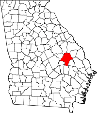 | |
| CDPs | ||
| Footnotes | ‡This populated place also has portions in an adjacent county or counties | |