Nova Friburgo
| Nova Friburgo | ||
|---|---|---|
| Municipality | ||
|
Center of Nova Friburgo seen from Rio de Janeiro State University | ||
| ||
 Nova Friburgo Location in Brazil | ||
| Coordinates: 22°16′55″S 42°31′52″W / 22.28194°S 42.53111°WCoordinates: 22°16′55″S 42°31′52″W / 22.28194°S 42.53111°W | ||
| Country |
| |
| Region | Southeast Region | |
| State | Rio de Janeiro | |
| Area | ||
| • Total | 933 km2 (360 sq mi) | |
| Population (2015) | ||
| • Total | 184,786 | |
| • Density | 200/km2 (510/sq mi) | |
| Time zone | BRT/BRST (UTC-3/-2) | |
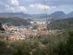

Nova Friburgo (Portuguese pronunciation: [ˈnɔvɐ fɾiˈbuʁɡu], German: Neufreiburg, English: New Fribourg, commonly referred to as just "Friburgo") is a municipality in the state of Rio de Janeiro in southeastern Brazil. It is located in the mountainous region, in the Center Mesoregion of the state, 136 km (85 mi) from its capital Rio de Janeiro. The town is 846 metres (2,776 ft) above sea level. Its population was 184,786 (2015) and its area is 933 km².[1]
The main economic activities are the undergarment industry, olericulture, goat raising, various industries (textile, clothing, metallurgy) and tourism. It’s also the coldest city of the state.
History


Up to the 19th century, the region of the present Nova Friburgo was inhabited by Coroado Purí Indians.[2][3] In 1818, King John VI was interested in improving the relationship with Germany, in order to obtain support against the French empire. He then proposed a planned settlement that would promote the civilization in Brazil. A royal decree authorized the Canton of Fribourg, in Switzerland, to establish a colony of 100 Swiss families in the Morro Queimado Farm, in Cantagalo District, a place with climate and natural characteristics similar to those in their country.
Between 1819 and 1820, the region was settled by 265 Swiss families, in total 1,458 immigrants. It was named Nova Friburgo (New Fribourg) by the Swiss after the homeland of most of the families.
Following the Independence of Brazil in 1822, the Imperial Government continued the policy of populating the nation by attracting European colonization. Eighty German families previously assigned to settlements in the Province of Bahia, for unknown reasons ended up in Nova Friburgo, where they arrived on the 3 and 4 May 1824.[4] Similar arrivals of Italians, Portuguese and a minority of Syrians led to such population increases that the once village was elevated to city status on 8 January 1890.
In 1872, the Baron of Nova Friburgo brought to the region the Leopoldina Railroad, to allow for the flow of the coffee from Cantagalo. Agriculture was the basis of economic activity until 1910, when the arrival of industrialists pioneered the development of an industrial sector still thriving to the present day. Of similar importance was the relative proximity to Niterói and Rio de Janeiro and the improvement of transport and communication links such as paved roads and telegraph. This encouraged a small tourist industry to grow, which, together with local commerce, became the main source of income for the city.
Nova Friburgo was affected by the 2011 Brazilian floods on 11 January with mudslides causing at least 820 deaths and more than 200 people to go missing in the biggest natural disaster in the history of Brazil. The population was left with no water, electricity, food or gas.[5][6]
Climate

Nova Friburgo has a highland tropical climate (Köppen climate classification Cwa), with fresh and dry winters and humid and mild summers. Annual average temperature is 19 °C (66 °F).
Economy
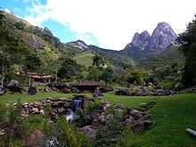
The city has a strong drive towards tourism due to the landscape, rivers, trails and bucolic spots. It has the second largest network of hotels of the state, after the capital Rio de Janeiro. The urban district is visited for its cold climate, the tranquility and romanticism. However, there are also attractions more distant to the center, which are appreciated by those who are interested in ecotourism and adventure sports like rafting and canoeing. The district of Lumiar is one of the most important sites for these sports in the state.
Nova Friburgo is known as the national capital of the undergarment industry, due to the vast production and variety of models, and the local brands begin to compete in the international market. Other major industries include textile mills and metallurgic industries.
Agriculture is important in the area of olericulture and goat raising, as well as in the production of flowers, of which the municipality is the second largest producer in the country, surmounted only by Holambra, in the state of São Paulo.
The municipality contains part of the Central Rio de Janeiro Atlantic Forest Mosaic of conservation units, created in 2006.[7] It contains 33,992 hectares (84,000 acres) of the 35,038 hectares (86,580 acres) Macaé de Cima Environmental Protection Area, created in 2001.[8]
Tourism

The main attractions of the city are:
- Alpine-style architecture of the buildings of MuryShopping, the Bucsky and Garlipp hotels and the restaurant Bräun & Bräun
- "Casa Suiça" (the Swiss House)
- Cheese-making school FRIALP
- District of Lumiar
- District of São Pedro da Serra
- Encontro dos Rios (merging of rivers Macaé and Bonito)
- Gastronomic center, in the district of Mury
- Getulio Vargas Square
- Marcilio Dias Square, which marks the beginning of the settlement, for it’s the area where the first Germans camped, coming from Europe
- Nova Friburgo Country Club
- Park of Furnas do Catete, with the Cão Sentado (Sitting Dog) Stone
- Pedra Riscada (scratched stone)
- Saint John Baptist Cathedral
- Suspiro Square, with the biggest chairlift of the country
- The municipality contains 19% of the 46,350 hectares (114,500 acres) Três Picos State Park, created in 2002.[9]
Demographics
- Population: 202,085
- Urban: 178,377
- Rural: 23,708
- Male: 97,253
- Female: 104,832
Racial composition
- White: 78,3%
- Pardo (multiracial): 13,9%
- Black: 7,0%
- Asian: 0,1%
- Indigenous: 0,1%
- 0,5% not reported
(Source: IBGE)
Ethnic groups
Portuguese, Swiss, German, Italian, Austrian, Spanish, Lebanese, African, Hungarian, Japanese.
Gallery
 Alberto Braune Avenue in 1940
 Gloria Hotel (right), 1940
 Anchieta School
 Side view of the school
 District of Lumiar, outskirts of Nova Friburgo
 Park Hotel
 Campus of Rio de Janeiro State University in Nova Friburgo
 Countryside
 Horses in a bucolic scene in the rural region of the municipality
 Vale dos Frades (Frades Valley)
 View of Nova Friburgo from Caledônia peak
Sister cities
-
 Fribourg, Switzerland
External links
References
- ↑ IBGE -
- ↑ Os índios de Sumidouro. Available in http://sumidouro.chez.com/indios.htm. Access on 9 September 2012.
- ↑ Nova Friburgo entra para a história. Available in http://www.swissinfo.ch/por/specials/Suicos_do_estrangeiro/Nova_Friburgo_entra_para_a_historia.html?cid=875208. Access on 9 September 2012.
- ↑ http://www.luteranos.com.br/201/historico.html. Missing or empty
|title=(help) - ↑ "Death toll mounts from flooding in Rio de Janeiro state". BBC News. BBC. 12 January 2011. Retrieved 13 January 2011.
- ↑ Tom Phillips (14 January 2011). "Brazil Landslides Death Toll Rises". The Guardian. Retrieved 14 January 2011.
- ↑ Costa, Cláudia; Lamas, Ivana; Fernandes, Rosan (December 2010), Planejamento Estratégico do Mosaico Central Fluminense (PDF) (in Portuguese), Reserva da Biosfera da Mata Atlântica, p. 13, retrieved 2016-10-02
- ↑ Luiz Dias da Mota Lima (2014), Plano de Manejo da Área de Proteção Ambiental Estadual Macaé de Cima (PDF) (in Portuguese), 1 - Informações Gerais sobre a UC, Rio de Janeiro, p. 20, retrieved 2016-10-11
- ↑ PES dos Três Picos (in Portuguese), ISA: Instituto Socioambiental, retrieved 2016-10-03
Capital: Rio de Janeiro | |||||||||||||||||||
| Mesoregion Baixadas |
|  | |||||||||||||||||
| Mesoregion Centro Fluminense |
| ||||||||||||||||||
| Mesoregion Metropolitana do Rio de Janeiro |
| ||||||||||||||||||
| Mesoregion Noroeste Fluminense |
| ||||||||||||||||||
| Mesoregion Norte Fluminense |
| ||||||||||||||||||
| Mesoregion Sul Fluminense |
| ||||||||||||||||||