Notre Dame, Indiana
| Notre Dame, Indiana | |
|---|---|
| Census-designated place | |
|
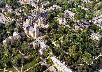
An aerial view of the University of Notre Dame's center campus. | |
 Notre Dame, Indiana | |
| Coordinates: 41°42′01″N 86°14′19″W / 41.70028°N 86.23861°WCoordinates: 41°42′01″N 86°14′19″W / 41.70028°N 86.23861°W | |
| Country | United States |
| State | Indiana |
| County | St. Joseph |
| Township | Clay, Portage |
| Area[1] | |
| • Total | 1.274 sq mi (3.30 km2) |
| • Land | 1.208 sq mi (3.13 km2) |
| • Water | 0.066 sq mi (0.17 km2) |
| Elevation[2] | 735 ft (224 m) |
| Population (2010)[3] | |
| • Total | 5,973 |
| • Density | 4,700/sq mi (1,800/km2) |
| Time zone | Eastern (EST) (UTC-5) |
| • Summer (DST) | EDT (UTC-4) |
| ZIP code | 46556 |
| Area code(s) | 574 |
| GNIS feature ID | 2583462 |
Notre Dame is a census-designated place[4] north of South Bend in St. Joseph County, in the U.S. state of Indiana. It includes the campuses of three colleges: the University of Notre Dame, Saint Mary's College, and Holy Cross College. Notre Dame is split between Clay and Portage Townships. As of the 2010 census, its population was 5,973.[3]
Holy Cross Religious Communities

Holy Cross Village at Notre Dame is a retirement community offering continuing care in Notre Dame, Indiana. It is owned by the Brothers of Holy Cross and managed by the Franciscan Sisters of Chicago Service Corporation.
Notre Dame, Indiana is also the home of three major headquarters of Holy Cross religious communities. On the campus of Saint Mary's College the Sisters of the Holy Cross have their Congregational Administration. The Holy Cross College campus is the location of the Provincial Offices of two provinces of the Congregation of Holy Cross: the Midwest Province of Brothers and the Indiana Province of Priests and Brothers.
Government and infrastructure
As unincorporated communities do not have a municipal government, Notre Dame, Indiana's government entities are the United States post office and the colleges' police forces. All colleges and universities in Indiana are entitled to an independent police force by law.[5] The University of Notre Dame also has its own fire department and supplies its own water and power utilities, except University Village and Cripe Street Apartments, Notre Dame's family and married housing get their electricity from AEP.
A post office has been in operation at Notre Dame since 1851.[6] The United States Postal Service Notre Dame Post Office is located in the southwest corner of Hammes Mowbray Hall, west of East Gate along Juniper Road on the University of Notre Dame campus.[7][8][9]
References
- ↑ "US Gazetteer files: 2010, 2000, and 1990". United States Census Bureau. 2011-02-12. Retrieved 2011-04-23.
- ↑ "US Board on Geographic Names". United States Geological Survey. October 25, 2007. Retrieved 2016-11-06.
- 1 2 "American FactFinder". United States Census Bureau. Retrieved 2011-05-14.
- ↑ "Notre Dame, Indiana". Geographic Names Information System. United States Geological Survey.
- ↑ "Indiana Code 21-17-5-2.1. State of Indiana. 2007. Retrieved on January 4, 2011.
- ↑ "Saint Joseph County". Jim Forte Postal History. Retrieved 1 December 2015.
- ↑ "Post Office Location - NOTRE DAME." United States Postal Service. Retrieved on December 6, 2008.
- ↑ "Campus Map." University of Notre Dame. Retrieved on December 7, 2008.
- ↑ "Notre Dame Post Office." ''University of Notre Dame. Retrieved on December 7, 2008.
Municipalities and communities of St. Joseph County, Indiana, United States | ||
|---|---|---|
| Cities | ||
| Towns | ||
| Townships | ||
| CDPs | ||
| Unincorporated communities |
| |
| Footnotes | ‡This populated place also has portions in an adjacent county or counties | |