Northala Fields
Coordinates: 51°32′24.32″N 0°22′25.65″W / 51.5400889°N 0.3737917°W

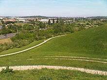
Northala Fields is an award-winning[1] country-style park located in Northolt, Greater London. It was opened in 2008 and consists of four artificial hills standing next to the A40 Western Avenue, as well as several fishing lakes and a large field area.[2] The hills were constructed using rubble from the demolition of the original Wembley Stadium, which was closed in 2000 and demolished in 2003. The park was created as part of the Northolt and Greenford Country Park project, and backs onto the older Rectory Park.
The name "Northala" is how the old manor of Northall (Northolt) was recorded in the Domesday book in 1086.[3]
It is situated on what was the Royal Borough of Kensington Playing Fields after being leased to them in 1938.[a] The section of the Ealing Road that formed the eastern perimeter was then renamed Kensington Road.[4]
Notes
a. ^ Chelsea was then a separate metropolitan borough-whilst the name of the lessee changed in 1965; when the two boroughs amalgamated, the name of the playing fields did not.
References
- ↑ Public art online: "Major awards for Northala Fields - Europe's largest land art"
- ↑ "Northala Fields". Ealing Council. Retrieved 15 May 2016.
- ↑ The Environs of London: volume 3: County of Middlesex (1795), Northall (Northolt) pp. 306-319. Accessed 17 February 2010
- ↑ A History of the County of Middlesex: Volume 4: Harmondsworth, Hayes, Norwood with Southall, Hillingdon with Uxbridge, Ickenham, Northolt, Perivale, Ruislip, Edgware, Harrow with Pinner (1971) "Northolt: Introduction", pp. 109-113. 17 February 2010
External links
| Wikimedia Commons has media related to Northala Fields. |