Illinois Route 64
| ||||
|---|---|---|---|---|
| North Avenue | ||||
| Route information | ||||
| Maintained by IDOT | ||||
| Length: | 135.99 mi[1] (218.85 km) | |||
| Existed: | 1924[2] – present | |||
| Major junctions | ||||
| West end: |
| |||
| East end: |
| |||
| Location | ||||
| Counties: | Carroll, Ogle, DeKalb, Kane, DuPage, Cook | |||
| Highway system | ||||
| ||||

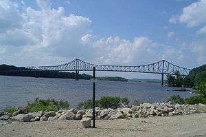
Illinois Route 64 (IL 64) is an east–west state highway in Northern Illinois. Its western terminus is at the Iowa state line, connecting with U.S. Route 52 (US 52) and Iowa Highway 64 via the Savanna-Sabula Bridge at the Mississippi River west of Savanna. IL 64 then travels east through Mount Carroll, Lanark, Mount Morris, Oregon, Sycamore, Lily Lake, Saint Charles and the western suburbs of Chicago before terminating at U.S. Route 41 (US 41, Lake Shore Drive) on the city's north side. IL 64 is 138.82 miles (223.41 km) long.[1]
Route description

IL 64 overlaps US 52 between the Iowa state line and Brookville—a distance of over 20 miles (32 km)—so that the IL 64 designation can carry over to Iowa. East of the Mississippi River, IL 64 is largely a rural, undivided surface road from Savanna to the Fox River in Saint Charles.
At St. Charles, IL 64 enters the Chicago metro area and becomes a four-lane road, taking on the name of Main Street. Just east of St. Charles, IL 64 becomes North Avenue and retains this designation until just before its terminus in Chicago at US 41 (Lake Shore Drive). At IL 59, the road widens further from four to six lanes and becomes a divided highway until its intersection with IL 83 in Elmhurst. From Elmhurst to Interstate 294 (I-294) it remains a four-lane surface street, but it widens to a six-lane divided highway once again through the towns of Stone Park and Northlake. At the Des Plaines River and IL 43, North Avenue becomes four lanes until it reaches Nort Western Avenue. At this point, it becomes at times a two-lane road, for the rest of its route through Chicago. One-half mile (0.8 km) west of US 41, IL 64 turns north onto LaSalle Boulevard, and then east, before terminating at Lake Shore Drive.
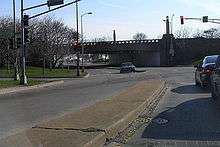
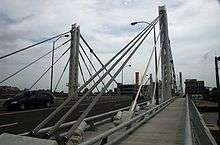
North Avenue is a main east–west artery in Chicago itself, and one of only seven state routes to enter the city. It is located at the 1600 North parallel of Chicago. Just east of the Kennedy Expressway (I-90/I-94), the North Avenue Bridge carries IL 64 over the North Branch of the Chicago River. The hybrid suspension/cable-stayed bridge was built in 2006, replacing a bascule bridge dating back to 1907.
Between Halsted and Sheffield Avenues, North Avenue has become a shopping destination, known as the Clybourn Corridor.
History
.jpg)
State Bond Initiative Route 64 was IL 64 from Sycamore to Chicago. The portion of the road in DuPage County was put through in 1928, the first 40-foot (12 m) highway through the county.[3] In 1937, the road was extended west from Sycamore to what was then US 51 (and is now IL 251). Afterwards, it was extended further west to US 52, and then following it to the state line. Much like IL 92, there is no particular reason for extending IL 64 through Iowa and Nebraska, as existing U.S. Routes served any major cities on the State Route 64s better.[2]
Major junctions
| County | Location | mi | km | Destinations | Notes |
|---|---|---|---|---|---|
| Jackson | Union Township | Continuation in Iowa | |||
| Mississippi River | 0.00 | 0.00 | Savanna–Sabula Bridge | ||
| Carroll | Savanna | 0.13 | 0.21 | West ends of IL 84 and Great River Road overlaps | |
| 2.19 | 3.52 | East ends of IL 84 and Great River Road overlaps | |||
| Mount Carroll | 11.09 | 17.85 | |||
| Lanark | 18.69 | 30.08 | |||
| Rock Creek–Lima Township | 28.62 | 46.06 | East end of US 52 overlap | ||
| Ogle | Lincoln Township | 33.70 | 54.23 | North end of IL 26 overlap | |
| 34.21 | 55.06 | South end of IL 26 overlap | |||
| Oregon | 48.31 | 77.75 | |||
| White Rock Township | 62.26 | 100.20 | |||
| Lynnville Township | 64.57 | 103.92 | |||
| DeKalb | Sycamore | 81.61 | 131.34 | West end of IL 23 overlap | |
| 82.13 | 132.18 | East end of IL 23 overlap | |||
| Kane | Lily Lake | 90.90 | 146.29 | ||
| St. Charles | 100.07 | 161.05 | |||
| 100.36 | 161.51 | ||||
| DuPage | West Chicago | 105.66 | 170.04 | ||
| Lombard | 114.56 | 184.37 | Toll barriers on southbound entrance and northbound exit ramps | ||
| 114.85 | 184.83 | ||||
| Elmhurst | 118.33 | 190.43 | |||
| DuPage–Cook county line | 120.31– 120.66 | 193.62– 194.18 | No access from westbound I-290; eastbound exit to I-294 only; no access from westbound US 20 | ||
| Cook | Northlake | 122.33– 122.77 | 196.87– 197.58 | Interchange | |
| Melrose Park | 125.03 | 201.22 | |||
| Chicago | 126.54 | 203.65 | |||
| 129.62 | 208.60 | ||||
| 133.80 | 215.33 | ||||
| 135.94 | 218.77 | ||||
| 135.99 | 218.85 | Roundabout on shore of Lake Michigan | |||
1.000 mi = 1.609 km; 1.000 km = 0.621 mi
| |||||
Truck route
| |
|---|---|
| Location: | Elmhurst |
IL 64 has one alternate route; Illinois Route 64 Truck (IL 64 Truck), a bypass around a truck-prohibited, residential section of Elmhurst. Eastbound truck traffic is rerouted north along IL 83, east along US 20 (Lake Street) and then onto I-290 before being allowed to return to IL 64. Westbound truck traffic follows the same route in reverse.
As early as 1989, the City of Elmhurst had sought to block trucks from traveling on North Avenue through its city limits. For a time, Illinois House of Representatives minority leader Lee Daniels supported a plan to reduce North Avenue from four lanes to two, prohibiting trucks from traveling through the residential neighborhood.[4] By 1994, the village had agreed to reconstruct North Avenue and add a single set of left-turn lanes at Myrtle Avenue.[5] Reconstruction of North Avenue in Elmhurst took place in 1997.[6]
References
- 1 2 Illinois Technology Transfer Center (2011). "T2 GIS Data". Illinois Department of Transportation. Retrieved May 11, 2013.
- 1 2 Carlson, Rick (March 15, 2006). "Routes 61 through 80". Illinois State Highways Page. Retrieved March 24, 2006.
- ↑ Crisler, Amy E. "Glendale Heights". History of DuPage County. Retrieved December 6, 2013.
- ↑ Mehler, Neil H. (July 14, 1989). "Elmhurst seeks truck ban on North Avenue". Chicago Tribune. Retrieved July 17, 2008.
- ↑ Mannion, Annemarie (January 13, 1994). "North Ave. plan now ready". Chicago Tribune. Retrieved July 17, 2008.
- ↑ "North Avenue, other streets to open after re-pavement". Chicago Tribune. November 18, 1997. Retrieved July 17, 2008.
External links
| Wikimedia Commons has media related to Illinois Route 64. |