Norba
- This article is about the ancient Italian town. For the National Off-Road Bicycle Association in the United States, see NORBA. For the Roman colony in Lusitania, see Alcántara.
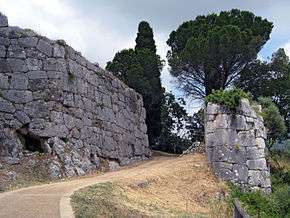 "Porta Maggiore", the main gate of Norba | |
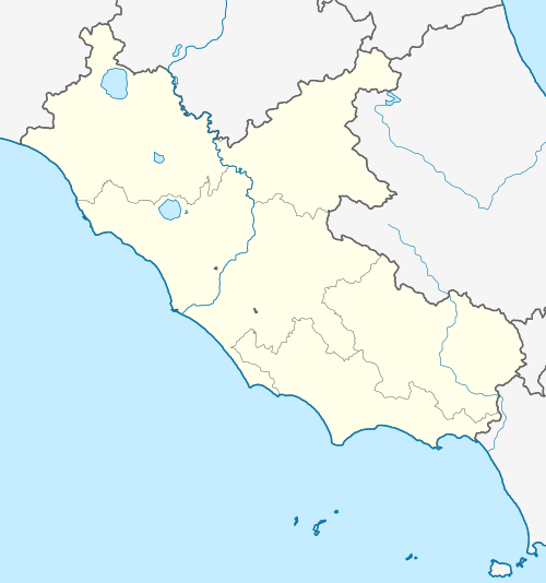 Shown within Lazio | |
| Location | Comune di Norma, Lazio, Italy |
|---|---|
| Region | Lazio |
| Type | Settlement |
| History | |
| Founded | 492 BC |
| Periods | Roman Republic |
| Cultures | Ancient Rome |
| Site notes | |
| Excavation dates | yes |
| Archaeologists | Raniero Mangarelli; Luigi Savignóni; Stefania Quilici Gigli |
| Management | Soprintendenza Archeologica per il Lazio |
| Public access | yes |
| Website | Norba (Italian) |
Norba, an ancient town of Latium (Adjectum), Italy. It is situated 1 mile northwest of the modern town of Norma, on the western edge of the Volscian Mountains or Monti Lepini. The town is perched above a precipitous cliff with a splendid view over the Pomptine Marshes below; the highest point stands to ca. 460 meters (over 1500 feet) above sea level.[1]
History
Norba was a member of the Latin League of 499 BC. It became a Roman colony in 492 BC, initially to protect the border with the Volsci,[2] and later serving as an important fortress guarding the Pomptine Marshes. It served in 199 BC as a place of detention for the Carthaginian hostages, and was captured and destroyed by Sulla's troops during the civil wars at the end of 82 BC. By the first century AD Norba is included by Pliny the Elder on his list of extinct cities in Latium.[3]
Archaeology
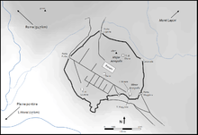
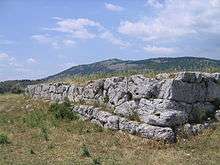
From excavations begun in 1901 it seems clear that the remains now visible on the site are entirely Roman.[4] The well-preserved walls are in the polygonal style, over 2.5 km in circuit, and are entirely embankment walls, not standing free above the internal ground level. The walls enclose an area of approximately 38 hectares. Remains of two towers, and of several gateways (notably the Porta Maggiore, defended by a tower), exist. The bastion at the Porta Maggiore still stands to 13 m. A square tower, referred to as "La Loggia" is also to be found along the curtain.[5][6]
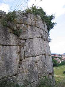
The main gate is enormous, with jambs over 8 m in height, 4.30 m in width, and internal width of 12.8 m. Within, the remains of several, buildings, including the foundations (podia) of two temples, one dedicated to Juno Lucina, have been examined. At the foot of the cliff are the picturesque ruins of the medieval town of Ninfa, (12th-13th centuries) abandoned on account of malaria. The remains of a primitive settlement, on the other hand, have been discovered on the mountainside to the southeast, above the 13th-century abbey of Valvisciolo, where there is a succession of terraces supported by walls of rough polygonal masonry, and approached by a road similarly supported. Here a quantity of primitive pottery has been found.[7] The necropolis of this settlement was probably the extensive one situated at Caracupa (8th-7th century BC), near the railway station of Sermoneta, which belongs also to the 8th-6th century BC, terminating thus at the precise date at which the Roman city of Norba is believed to have been established.[8]
Additional ancient remains are to be found in the hinterland of Norba, including the polygonal masonry structure at Poggio Serrone di Bove.[9]
References
- ↑ Giulio Schmiedt; Ferdinando Castagnoli (1957). L'antica città di Norba: documentazione aerofotogrammetrica. Istituto Geografico Militare.
- ↑ Livy, Ab urbe condita, 2:34
- ↑ http://latin.packhum.org/loc/978/1/240/171-177#240 Historia Naturalis 3.69.1
- ↑ L. Savignoni and R. Mengarelli in Notizie degli Scavi 1901 and 1904.
- ↑ http://www.treccani.it/enciclopedia/norba_(Enciclopedia-dell'-Arte-Antica)/
- ↑ Jeffrey Alan Becker (2007). The Building Blocks of Empire: Civic Architecture, Central Italy, and the Roman Middle Republic. ProQuest. pp. 19–. ISBN 978-0-549-55847-7.
- ↑ L. Quilici and S. Quilici Gigli. 1987. "L'abitato di Monte Carbolino." Archeologia Laziale VIII (QuadAEI, 14):259-277
- ↑ Papers of the British School at Rome. R. Clay and Sons. 1906. pp. 80–.
- ↑ S. Quilici Gigli “Insediamenti nel territorio di Norba: il Poggio di Serrone di Bove” ArchLaz 9 (1988) 227-32.
External links
Coordinates: 41°35′30″N 12°57′37″E / 41.59167°N 12.96028°E
 This article incorporates text from a publication now in the public domain: Chisholm, Hugh, ed. (1911). "article name needed". Encyclopædia Britannica (11th ed.). Cambridge University Press.