Mykolaiv Oblast
| Mykolaiv Oblast Миколаївська область Mykolayivs’ka oblast’ | |||
|---|---|---|---|
| Oblast | |||
| |||
| Nickname(s): Миколаївщина (Mykolayivschyna) | |||
 | |||
| Coordinates: 47°26′N 31°48′E / 47.43°N 31.8°ECoordinates: 47°26′N 31°48′E / 47.43°N 31.8°E | |||
| Country |
| ||
| Administrative center | Mykolaiv | ||
| Government | |||
| • Governor | Oleksiy Savchenko[1] (Petro Poroshenko Bloc[1]) | ||
| • Oblast council | 90[2] seats | ||
| • Chairperson | Victoria Moskalenko[3] (Petro Poroshenko Bloc[3]) | ||
| Area | |||
| • Total | 24,598 km2 (9,497 sq mi) | ||
| Area rank | Ranked 14th | ||
| Population (2015) | |||
| • Total |
| ||
| • Rank | Ranked 18th | ||
| Time zone | EET (UTC+2) | ||
| • Summer (DST) | EEST (UTC+3) | ||
| Postal code | 54000-56999 | ||
| Area code | +380-51 | ||
| ISO 3166 code | UA-48 | ||
| Raions | 19 | ||
| Cities (total) | 10 | ||
| • Regional cities | 5 | ||
| Urban-type settlements | 17 | ||
| Villages | 820 | ||
| FIPS 10-4 | UP16 | ||
| Website |
www.mykolayiv-oda.gov.ua www.kmu.gov.ua | ||

Mykolaiv Oblast (Ukrainian: Миколаївська область, Mykolajivśka oblasť'; also referred to as Mykolayivshchyna - Ukrainian: Миколаївщина) is an oblast (province) of Ukraine. The administrative center of the oblast is the city of Mykolaiv. Population: 1,164,342 (2015 est.)[4]
Geography
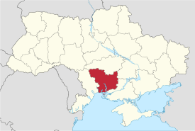
The Mykolaiv Oblast is located in the southern half of Ukraine. Its area (24,600 km²), comprises about 4.07% of the total area of Ukraine.
The Mykolaiv Oblast borders upon the Odessa Oblast in the west-southwest, the Kirovohrad Oblast in the north, the Dnipropetrovsk Oblast in the northeast, and the Kherson Oblast on the southeast.
To the south the oblast is also bordered by the Black Sea. Along the coast there are several ports and the Mykolaiv International Airport.
Points of interest
The following historic-cultural sites were nominated for the Seven Wonders of Ukraine or Seven Natural Wonders of Ukraine.
- Olbia, an ancient ruins of Greek colony near Ochakiv
- Black Sea Biosphere Reserve, located near Kinburn peninsula
- Granite-steppe lands of Buh, a landscape park located up north towards Podolia
- Inhul River Park, a landscape park in eastern part of the region
- Tylihul landscape park, on the administrative border with Odessa Oblast
- Dykyỹ sad (Wild Garden)
Demographics
The current estimated population is 1.2 million people (as of 2005). The greater part of the oblast's population resides in urban type settlements (66%), with the remainder residing in agricultural areas. Also, almost 60% of the urban population resides in Mykolayiv, the industrial, cultural and administrative center of Mykolayiv Oblast.
The oblast's population density is one of the lowest in Ukraine – 52 people per 1 km². The oblast' is ranked 18 by the percentage of the population of Ukraine, that the Mykolaiv Oblast contain, which os 2.6%.
Age structure
- 0-14 years: 14.7%
 (male 88,668/female 83,434)
 - 15-64 years: 70.7%
 (male 396,342/female 432,808)
 - 65 years and over: 14.6%
 (male 56,527/female 114,987) (2013 official)
Median age
- total: 39.7 years
- male: 36.3 years
- female: 42.9 years (2013 official)
Administrative divisions
Mykolaiv Oblast formed in September 1937. It is subdivided into 19 raions (administrative districts), and 4 municipalities (misto) which are directly subordinate to the oblast government.
| Name | Ukrainian Name | Area (km2) | Population census 2015[5] | Admin.center | Urban Population Only |
|---|---|---|---|---|---|
| Mykolaiv | Миколаїв (місто) | 260 | 493,860 | Mykolaiv (city) | 493,860 |
| Pervomaisk | Первомайськ (місто) | 25 | 66,677 | Pervomaisk (city) | 66,677 |
| Voznesensk | Вознесенськ (місто) | 23 | 35,520 | Voznesensk (city) | 35,520 |
| Yuzhnoukrainsk | Южноукраїнськ (місто) | 24 | 40,353 | Yuzhnoukrainsk (city) | 40,353 |
| Arbuzynka Raion | Арбузинський (район) | 969 | 20,198 | Arbuzynka | 8,543 |
| Bashtanka Raion | Баштанський (район) | 1,706 | 37,721 | Bashtanka | 12,640 |
| Berezanka Raion | Березанський (район) | 1,378 | 23,409 | Berezanka | 4,120 |
| Bereznehuvate Raion | Березнегуватський (район) | 1,264 | 20,387 | Bereznehuvate | 7,742 |
| Bratske Raion | Братський (район) | 1,129 | 18,037 | Bratske | 5,325 |
| Domanivka Raion | Доманівський (район) | 1,458 | 25,500 | Domanivka | 6,137 |
| Kazanka Raion | Казанківський (район) | 1,349 | 19,745 | Kazanka | 7,207 |
| Kryve Ozero Raion | Кривоозерський (район) | 814 | 24,905 | Kryve Ozero | 7,823 |
| Mykolaiv Raion | Миколаївський (район) | 1,430 | 30,448 | Mykolaiv (city) | N/A * |
| Novyi Buh Raion | Новобузький (район) | 1,243 | 31,199 | Novyi Buh | 15,566 |
| Nova Odesa Raion | Новоодеський (район) | 1,428 | 33,602 | Nova Odesa | 12,108 |
| Ochakiv Raion | Очаківський (район) | 1,500 | 29,949 | Ochakiv | 14,489 |
| Pervomaisk Raion | Первомайський (район) | 1,319 | 30,275 | Pervomaisk (city) | N/A * |
| Snihurivka Raion | Снігурівський (район) | 1,350 | 40,420 | Snihurivka | 12,870 |
| Veselynove Raion | Веселинівський (район) | 1,245 | 23,161 | Veselynove | 8,060 |
| Vitovka Raion | Вітовській (район) | 1,460 | 50,565 | Mykolaiv (city) | N/A * |
| Voznesensk Raion | Вознесенський (район) | 1,392 | 30,562 | Voznesensk (city) | N/A * |
| Vradiivka Raion | Врадіївський (район) | 801 | 17,611 | Vradiivka | 8,391 |
| Yelanets Raion | Єланецький (район) | 1,018 | 15,530 | Yelanets | 4,912 |
| Total Oblast | Миколаївська (Область) | 24,585 | 1,159,634 | 791,227 |
Note: Asterisks (*) Though the administrative center of the rayon is housed in the city/town that its named after, cities do not answer to the rayon authorities only towns do; instead they are directly subordinated to the oblast government and therefore are not counted as part of rayon statistics.
At a lower level of administration, these district-level administrations are subdivided into:
- Settlements — 922, including:
- Villages — 896;
- Cities/Towns — 21, including:
- Cities of raion subordinance — 4 (Bashtanka, Novyi Buh, Nova Odesa and Snihurivka);
- Urban-type settlement — 17;
- Selsovets — 287.
The local administration of the oblast is controlled by the Mykolaiv Oblast Rada. The governor of the oblast is the Mykolaiv Oblast Rada speaker, appointed by the President of Ukraine.
Public opinion
During the 1991 referendum, 89.45% of votes in Mykolaiv Oblast were in favor of the Declaration of Independence of Ukraine. A survey conducted in December 2014 by the Kyiv International Institute of Sociology found 2.1% of the oblast's population supported their region joining Russia, 95.5% did not support the idea, and the rest were undecided or did not respond.[6]
See also
References
- 1 2 https://www.kyivpost.com/ukraine-politics/poroshenko-appoints-mp-oleksiy-savchenko-mykolaiv-regional-governor.html
- ↑ Regions Party wins 60 seats on Mykolaiv City Council, Kyiv Post (Nov. 5, 2010)
- 1 2 https://news.pn/en/politics/149828
- 1 2 "Чисельність наявного населення України (Actual population of Ukraine)" (PDF) (in Ukrainian). State Statistics Service of Ukraine. Retrieved 1 July 2016.
- ↑ "Population Quantity". UkrStat (in Ukrainian). Retrieved 7 January 2016.
- ↑ Лише 3% українців хочуть приєднання їх області до Росії [Only 3% of Ukrainians want their region to become part of Russia]. Dzerkalo Tyzhnia (in Ukrainian). 3 January 2015.
External links
- State Administration of Mykolaiv Oblast - official site (Ukrainian)/(Russian)/(English)
- Information Card of the Region - official site of the Cabinet of Ministers of Ukraine
| Raions | |||||||
|---|---|---|---|---|---|---|---|
| Cities |
| ||||||
| |||||||
 |
Kirovohrad Oblast | Dnipropetrovsk Oblast | | |
| Odessa Oblast | |
Zaporizhia Oblast | ||
| ||||
| | ||||
| Odessa Oblast | Black Sea | Kherson Oblast |