States of Nigeria
| States of Nigeria | |
|---|---|
 | |
| Category | Federated state |
| Location | Federal Republic of Nigeria |
| Number | 36 States |
| Populations | 1,739,136 (Ebonyi) – 21,000,534 (Lagos) |
| Areas | 3,580 km2 (1,381 sq mi) (Lagos) – 76,360 km2 (29,484 sq mi) (Niger) |
| Government | State government |
| Subdivisions | Local Government Area |
 |
| This article is part of a series on the politics and government of Nigeria |
|
|
A Nigerian State is a federated political entity, which shares sovereignty with the Federal Government of Nigeria, There are 36 States in Nigeria, There is also a territory called the Federal Capital Territory (FCT), which is not a state, but a territory, under the direct control of the Federal Government. The States are further divided into a total of 774 Local Government Areas.[1] Under the Nigerian Constitution States have the power to ratify constitutional amendments.
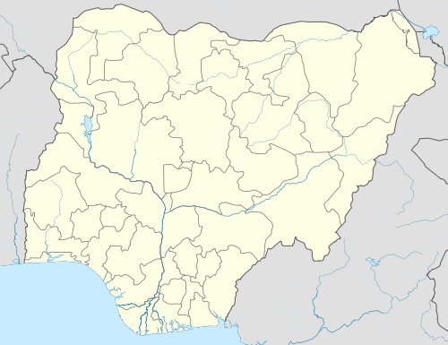
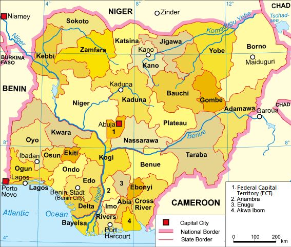
Current states and the Federal Capital Territory of Abuja
|
A clickable map of Nigeria exhibiting its 36 states and the federal capital territory.

| ||||||||||||
Former state boundaries
Before and after independence in 1960, Nigeria was a Federal State of three Regions: Northern, Western, and Eastern. Provinces were also used in colonial times. In 1963, two provinces were detached from the Western Region to form the new Mid-Western Region. In 1967, the regions were replaced by 12 states due to a military decree; only the former Mid-Western Region escaped division, and formed a single state following the restructuring. From 1967 to 1970 the areas of Mid-Western State and the Eastern Region attempted to secede, as a nation called Biafra during the Nigerian civil war. In 1976, seven new states were created, making 19 altogether.[2]
The Federal Capital Territory was established in 1991. In 1987 two new states were established, followed by another nine in 1991, bringing the total to 30.[2] The latest change, in 1996, resulted in the present number of 36 states.
1991-1996
During this period, there were 30 states and the Federal Capital Territory.

1987-1991During this period, there were 21 states and,  |
|
1976-1987During this period, there were 19 states. 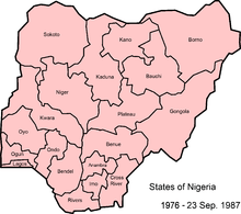 |
|
1967-1976During this period, there were 12 states.  |
1963-1967During this period, there were 4 regions.  |
|
1960-1963During this period, there were 3 regions.  |
|
Government
As sovereign entities, States of Nigeria have the right to organize/structure their individual governments in any way within the parameters set by the Constitution of Nigeria.
Chronology
| Regions | States | |||||
|---|---|---|---|---|---|---|
| 1960 | 1963 | 1967 | 1976 | 1987 | 1991 | 1996 |
| Eastern | South-Eastern | Cross-River | Akwa Ibom | |||
| Cross-River | ||||||
| East Central | Imo | Imo | ||||
| Abia | Abia | |||||
| Ebonyi | ||||||
| Anambra | Enugu | |||||
| Enugu | ||||||
| Anambra | ||||||
| Rivers | Bayelsa | |||||
| Rivers | ||||||
| Western | Mid-Western | Bendel | Delta | |||
| Edo | ||||||
| Western | Lagos | |||||
| Western | Ogun | |||||
| Ondo | Ekiti | |||||
| Ondo | ||||||
| Oyo | Osun | |||||
| Oyo | ||||||
| Northern | Benue-Plateau | Plateau | Nasarawa | |||
| Plateau | ||||||
| Benue | Benue | |||||
| Kogi | ||||||
| Kwara | ||||||
| Kwara | ||||||
| Kano | Jigawa | |||||
| Kano | ||||||
| North Central | Kaduna | Kaduna | ||||
| Katsina | ||||||
| North Western | Niger | |||||
| Sokoto | Kebbi | |||||
| Sokoto | Sokoto | |||||
| Zamfara | ||||||
| North Eastern | Bauchi | Bauchi | ||||
| Gombe | ||||||
| Borno | Borno | |||||
| Yobe | ||||||
| Gongola | Adamawa | |||||
| Taraba | ||||||
See also
- ISO 3166-2:NG
- List of state governors of Nigeria
- Lagos State
- Edo State
- Rivers State
- Ogun State
- Osun State
Notes
- ↑ "USAID Nigeria mission: Nigeria administrative divisions" United States Agency for International Development, October 2004, last accessed 21 April 2010
- 1 2 Kraxberger, Brennan (2005) "Strangers, Indigenes and Settlers: Contested Geographies of Citizenship in Nigeria" Space and Polity 9(1): pp. 9-27, pages 10, 11, & 15
Sources
- Ajayi, Gboyega (2007) The military and the Nigerian state, 1966-1993: a study of the strategies of political power control Africa World Press, Trenton New Jersey, ISBN 1-59221-568-8
- Benjamin, Solomon Akhere (1999) The 1996 state and local government reorganizations in Nigeria Nigerian Institute of Social and Economic Research, Ibadan, Nigeria, ISBN 978-181-238-9
- Suberu, Rotimi T. (1994) 1991 state and local government reorganizations in Nigeria Institute of African Studies, University of Ibadan, Ibadan, Nigeria, ISBN 978-2015-28-8
External links
- "New States of Nigeria". Statoids.
- Headline News in Nigeria States