Niederstetten
| Niederstetten | ||
|---|---|---|
|
Town hall | ||
| ||
 Niederstetten | ||
Location of Niederstetten within Main-Tauber-Kreis district 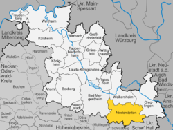 | ||
| Coordinates: 49°24′03″N 09°55′05″E / 49.40083°N 9.91806°ECoordinates: 49°24′03″N 09°55′05″E / 49.40083°N 9.91806°E | ||
| Country | Germany | |
| State | Baden-Württemberg | |
| Admin. region | Stuttgart | |
| District | Main-Tauber-Kreis | |
| Government | ||
| • Mayor | Rüdiger Zibold | |
| Area | ||
| • Total | 104.06 km2 (40.18 sq mi) | |
| Population (2015-12-31)[1] | ||
| • Total | 4,822 | |
| • Density | 46/km2 (120/sq mi) | |
| Time zone | CET/CEST (UTC+1/+2) | |
| Postal codes | 97996, 97980 (Mönchshof) | |
| Dialling codes | 07932, 07933, 07939 (Heimberg) | |
| Vehicle registration | TBB, MGH | |
| Website | www.niederstetten.de | |


| Wikimedia Commons has media related to Niederstetten. |
Niederstetten is a town and a municipality in the Main-Tauber district, in Baden-Württemberg, Germany. It is situated 14 km southeast of Bad Mergentheim, and 19 km west of Rothenburg ob der Tauber.
Sights

Inner courtyard of castle Haltenbergstetten
The main attraction is the Castle Haltenbergstetten. Germany's biggest pig market (every week on Monday morning)
Museum
The Albert-Sammt-Zeppelin-Museum is in memory of last German airship captain Albert Sammt and shows original parts as well as documents of Zeppelin history.
Economy, industry and infrastructure
Military
Niederstetten is home to German Army Aviation Transport Helicopter Regiment 30 based at Niederstetten Air Base.
International relations
Main article: List of twin towns and sister cities in Germany
Niederstetten is twinned with:
Towns and municipalities in Main-Tauber (district) | ||
|---|---|---|
References
This article is issued from Wikipedia - version of the 6/27/2015. The text is available under the Creative Commons Attribution/Share Alike but additional terms may apply for the media files.