Ngaraard
| Ngaraard | ||
|---|---|---|
| State | ||
| ||
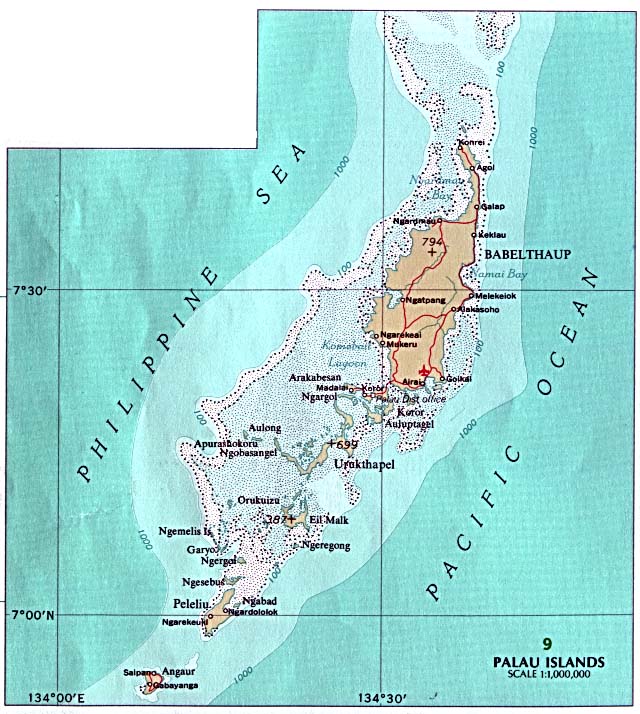
 Location of Ngaraard in Palau | ||
| Country |
| |
| Capital | Ulimang | |
| Population (2000) | ||
| • Total | 360 | |
| ISO 3166 code | PW-214 | |


Ngaraard is the eighth state of the Republic of Palau, and was originally named Kerradel. Ngaraard is located on the northern tip of Babeldaob directly adjacent to Ngarchelong state. There are five hamlets in Ngaraard, including Choll, Elab, Ngebuked, Ngkeklau and the state capital, Ulimang, located on the eastern shore of the state. Previously, the capital of Ngaraard was the village of Ngebuked, where the traditional leader of the state, Maderangebuked, lived and reigned. There is a saying in Ngaraard, A rengud a dokngei, meaning "everyone works together as one in spirit and in the heart."
History
Ngaraard's history can be divided into four eras corresponding to Spanish, German and Japanese domination up to World War II.
Spaniards & Germans
During the Spanish era a priest named Father Luis lived in Elab teaching Christianity. However, the people from Ngaraard did not accept Christianity, so he went to Melekeok to Chief Reklai, but no one there accepted it either, so he left for Ngchesar. On his way to Ngchesar, he became lost and fell ill. Chief Reklai heard about Father Luis so he sent people to look for him. They found Father Luis very sick, and the Melekeokians cared for him until he died. He was buried crosswise, unlike everyone else at the Uudes burial ground.
During the German era, the Germans passed laws that Palauans must work to grow various plants, those refusing would be sent to Ngebuked for imprisonment. This is one reasons explaining the many coconuts in Palau. Germans also outlawed marriage and any religion except Catholicism. Some people of Ngaraard moved to Angaur to work in the phosphate mines. Later, doctors from Angaur traveled to Ngebuked because of an outbreak of leprosy, sending the sick to Melekeok for healing. The leprosy outbreak resulted in the deaths of many Palauans.
Japanese Era and World Wars
During the Japanese era, there was a Japanese school in Ulimang, Ngaraard, offering primary education for first, second, and third grades. Students at the school came from Ngardmau, Ngerchelong, Kayangel and Ngaraard. Every morning students had assembly and they would bow to the Japanese as a sign of their respect and loyalty to the Japanese Emperor. Students found ignorant of their lessons would be punished by standing outside all day staring at the sun, or being forced to carry buckets of water up and down stairs for hours on end.
Ngaraard had two stores, the first selling sweets and clothing materials. The Nanboyeki store bought coconuts from all the islands. People lacking money could exchange coconuts for cloth. Many people from Ngaraard went to work at Angaur for phosphate mining; others went to Ngardmau to work on bauxite and some went to work for Nanboyeki. There were also Spanish priests in Koror who traveled to the islands propagating Christianity. When World War I started in Palau, people from Ngerchelong and Peleliu arrived in Ngaraard, where Taro Matsuda, Maderangebuked's younger brother, found families to host them.
When World War II began, most people fled to the jungles of Ngebuked. People wanting to go to the taro patch or go fishing needed permission from Japanese soldiers. When they finished working the taro patch or fishing they had to report to the Japanese soldiers, informing them they were finished. When American attacks began, people from Ngaraard were terrified because none had seen airplanes before. They called them "big bird with fire" (Meklou el kiued el ngarngii ngau el tuobed a ngerel). During that time, food ran short because the Japanese kept taking food from the Palauans. The people of Ngaraard left at night to find food because the American planes would not come, but they had to be careful because if Japanese soldiers saw them they would be killed.
The Japanese were ordered to collect Palauans and kill them. Japanese soldiers met with the Palau chiefs to discuss where to house the Peleliu people, because they planned to make Peleliu their military base. None of the chiefs wished to house the Peleliu people. Maderangebuked volunteered to take the Peleliu people, since Ngaraard had large taro patches and farms to produce food. This is why the Ngaraard people and Peleliu people have a special friendship.
There is Odesangel stone, this is an old name of Peleliu standing by Bai ra Ngaruau. The people of Peleliu who were in Ngebuked during the war carved the Odesangel Bad. They carved the stone as a memorial of the time they came out from hiding. "Odesangel Bad, 1945 28/9" is carved on the stone, showing that the people of Peleliu and those from Ngebuked and others that were hiding in the jungle emerged from their hiding place on September 28, 1945.
Cultural Background and Organization
It is said that the Ngebuked people were originally from Angaur, living on a mountain called Roisbuked. When Roisbuked became overpopulated and there was limited land for crops or food, the people from Angaur began looking for another island to live on. After leaving Roisbuked, they moved to Peleliu, called Ngerchol. When Ngerchol could not hold anymore people, they moved to Babeldaob, landing in a place between Melekeok and Ngaraard. After landing, they walked toward Ngiwal, but Ngiwal's inhabitants were unwelcoming so they moved to Ngaraard in Ngeteluang.
Ngebuked was divided into two sections, bita el ked ma bita el ked. The chief of one section was Kerai and in the other section was an old woman named Romei. When Romei could not hold all the responsibilities as chief, she asked Oiseuang, another older woman to rule. Two brothers from Ngeruangel sailed by and saw smoke rising at Ngebuked, so they stopped to get supplies. The older brother liked what he saw at Ngebuked and decided to stay; the younger brother traveled to other areas of Babeldaob. The younger brother ended up in Melekeok and became Chief of Melekeok and the older brother stayed in Ngebuked.
Oiseuang aged and could not perform her chiefly duties, so she looked for a person able to perform the work as the chief. She visited a man she felt was competent and asked if he would become a chief, and he asked he could be named Mad. Chief Mad united the two sections into one village of Ngebuked and so he became Mad ra Ngebuked. Kerai remained village head, meaning that when there was a contribution of food, he still received the portion for the first title, but the one who has the authority and power over Ngebukedd is Maderangebuked. Therefore, the order of chiefly title is that the first title is Maderangebuked, the second title is Kerai and the third is Techur. Techur had clan members from Ngeaur, Airai and Ngerchelong. Therefore, if a member from Angaur assumed the title then he would be called Techureaur, if a clan member from Ngerchelong assumed the title he would be called Techurchelong, and if he was from Airai he would be called Techurrulak.
Resources
Ngaraard has many natural resources, mainly forests and water. The landscape is mostly mountainous forest, sandy beaches on Desbedall and mangroves on the Keiukel side. There are many living things in Ngaraard's land, including fruit bats, pigeons, starlings, pigs, mangrove crabs, land crabs, cone shells (rechiil), shrimp in the creek, banded snakes (mengernger), aquatic snakes (kemaiirs), dogs, and cats. There are also many varieties of insects, including mosquitoes, wasps, bees, kerdard and many more.
One of the famous crops of Ngaraard is taro and its recipe, which uses taro leaves, coconut milk and land crab, is called demok. These are some other crops of Ngaraard: swamp cabbage (kangkum), tapioca (diokang), sweet potato (chemutii), giant swamp taro (brak), banana, calamondin (kingkang), breadfruits, ysaol, amra tree (titimel), Eugenia plant (chedebsachel), wax apple (rebotel), betelnut tree and pepper leaf (kebui). Ngaraard has a rich soil and plenty of crops but only a few vegetables.
Villages
The inhabited villages of Ngaraard State include the following (from north to south): Choll, Elab, Ulimang, Ngebuked, and Ngkeklau.
There are many important places in the State of Ngaraard. There are the traditional village sites of Elab, Chetoilechang, Diong er Ngerchokl, Bai ra Ngaruau, Chelsel a Beluu er Ngebuked, Diong era Imeduurang, Ulimang. Ulimang is said to be the child of god Chuab. Other important places include: Head Start, the elementary school and Bethania High School, a hospital, Bai ra Rubak, the Ngaraard State Office at Koror, Bem Yore and the stores.
The lifestyle of Ngaraard has changed a lot due to the introduction of modern technology, including computers, telephones, electricity and televisions. Due to the construction of roads, the majority of people in the state now use cars for transportation rather than boats. However boats are still used for fishing.
Population and Geography
The population of Ngaraard has changed considerably over the years. In 1990, its population was 440 and in 1996, it decreased to 360. In 2000, it had increased to 638. The Office of Statistics under the Ministry of Finance has not yet determined the total population for 2004.
Ngaraard has a tropical climate. The temperature ranges from a high of 83˙F to a low of 81˙F. Rainfall takes place from May to January and the heaviest rain is in June and July. The climate is dry from February until April.
Flag
Ngaraard recently changed its flag. It is made of a golden-yellow star on a field of deep sky blue. Behind the star, it has a red stripe from the bottom left corner to the upper right corner of the flag. The star stands for the unity of Ngaraard State, and the five fingers of the star stand for the five counties or hamlets of Ngaraard. The stripe of the flag shows that the state has both the east and west coast of northern Babeldaob and is striving for success. The blue background symbolizes the blue of the sky and ocean surrounding the Ngaraard State.
External links
Coordinates: 7°37′00″N 134°38′00″E / 7.6167°N 134.6333°E