New York State Route 81
| ||||
|---|---|---|---|---|
|
Map of eastern New York with NY 81 highlighted in red | ||||
| Route information | ||||
| Maintained by NYSDOT | ||||
| Length: | 22.49 mi[1] (36.19 km) | |||
| Existed: | 1930[2] – present | |||
| Major junctions | ||||
| West end: |
| |||
| East end: |
| |||
| Location | ||||
| Counties: | Albany, Greene | |||
| Highway system | ||||
| ||||


New York State Route 81 (NY 81) is an east–west state highway in the Capital District of New York in the United States. The western terminus of the route is at an intersection with NY 145 in the hamlet of Cooksburg within the town of Rensselaerville. Its eastern terminus is at a junction with U.S. Route 9W (US 9W) in the town of Coxsackie. East of US 9W, the right-of-way of NY 81 continues southeast to the village of Coxsackie as NY 385. NY 81 intersects NY 32 north of the hamlet of Cairo.
Route description
NY 81 begins at an intersection with NY 145 and Potter Hollow Road (unsigned NY 910G) in the hamlet of Cooksburg (in the town of Rennselaerville). NY 81 proceeds eastward through Rennselaerville, as a two-lane rural roadway, paralleling and crossing some power lines. After turning to the southeast, NY 81 crosses into the Greene County town of Durham. Entering the hamlet of Oak Hill, the route becomes a two-lane residential street, intersecting with the terminus of County Route 22 (CR 22; Oak Hill Road). After CR 22, NY 81 bends eastward out of Oak Hill, intersecting with the northern terminus of CR 27. Paralleling a nearby creek, CR 67 forks to the southeast, while NY 81 continues on its right-of-way through Durham. NY 81 bends northeastward, intersecting with the northern terminus of CR 75, where it turns eastward into the town of Greenville. In Greenville, NY 81 is the main street, remaining a two-lane residential street. Intersecting with CR 50 (North Road).[3]
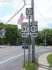
NY 81 continues eastward through Greenville, returning to being a rural two-lane highway and entering the hamlet of West Greenville. A short distance eastward, NY 81 enters the hamlet of Greenville, where it doubles as a residential-commercial street, where it crosses NY 32. After NY 32, the route forks to the southeast at an intersection with CR 26, which is quickly connected via CR 26A. Gradually bending eastward through the town of Greenville, NY 81 intersects with the northern terminus of CR 41 (Greenville Center Road). After CR 41, NY 81 bends to the southeast once again, winding past at an intersection with CR 35 (West Road), which terminates there. Making a dart eastward, NY 81 turns to the southeast past the hamlet of Surprise, where the route becomes a rural two-lane roadway once again. Just after Surprise, NY 81 enters the town of Coxsackie, winding southeastward past an intersection with CR 45, entering the hamlet of Earlton. The route remains rural, crossing intersections with CR 51 and CR 9 (Old Plank Road), bending to the northeast. Intersecting with a former alignment of itself, NY 81 turns eastward, intersecting with the eastern terminus of CR 26.[3]
After CR 26, NY 81 crosses over the New York State Thruway (I-87) then parallels another former alignment of itself. Through Coxsackie, NY 81 intersects with US 9W in a small commercial strip. This serves as the eastern terminus of NY 81, which continues eastward as NY 385 (Mansion Street).[3]
History
NY 81 was assigned as part of the 1930 renumbering of state highways in New York. It originally began at US 9W in the town of Coxsackie and ended at NY 30 in the village of Middleburgh. Along the way, it intersected NY 145, which ended at NY 81 in the hamlet of Cooksburg.[2][4] NY 81 was truncated to Cooksburg c. 1938, and its former routing to Middleburgh became an extension of NY 145.[5][6]
Major intersections
| County | Location | mi[1] | km | Destinations | Notes |
|---|---|---|---|---|---|
| Albany | Cooksburg | 0.00 | 0.00 | ||
| Greene | Community of Greenville | 10.31 | 16.59 | ||
| West Coxsackie | 22.49 | 36.19 | NY 385 continues south | ||
| 1.000 mi = 1.609 km; 1.000 km = 0.621 mi | |||||
See also
.svg.png) New York Roads portal
New York Roads portal
References
- 1 2 "2008 Traffic Volume Report for New York State" (PDF). New York State Department of Transportation. June 16, 2009. p. 137. Retrieved January 31, 2010.
- 1 2 Dickinson, Leon A. (January 12, 1930). "New Signs for State Highways". The New York Times. p. 136.
- 1 2 3 Microsoft; Nokia (April 17, 2012). "overview map of NY 81" (Map). Bing Maps. Microsoft. Retrieved April 17, 2012.
- ↑ Road Map of New York (Map). Cartography by General Drafting. Standard Oil Company of New York. 1930.
- ↑ New York (Map). Cartography by General Drafting. Standard Oil Company. 1937.
- ↑ New York Road Map for 1938 (Map). Cartography by General Drafting. Esso. 1938.
External links
| Wikimedia Commons has media related to New York State Route 81. |
- New York State Route 81 at Alps' Roads • New York Routes • New York State Highway Termini