New York State Route 695
| ||||
|---|---|---|---|---|
|
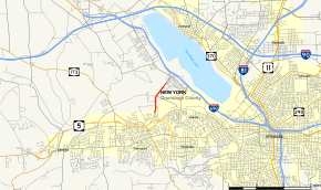
Map of Onondaga County in central New York with NY 695 highlighted in red | ||||
| Route information | ||||
| Maintained by NYSDOT | ||||
| Length: | 2.30 mi[1] (3.70 km) | |||
| Existed: | early 1980s[2][3] – present | |||
| Major junctions | ||||
| South end: |
| |||
| North end: |
| |||
| Location | ||||
| Counties: | Onondaga | |||
| Highway system | ||||
| ||||

New York State Route 695 (NY 695) is a short state highway located west of Syracuse in the towns of Camillus and Geddes in Onondaga County, New York. The number of the highway was derived from the two highways that NY 695 links, Interstate 690 (I-690) and NY 5. The northern end of the highway passes by the New York State Fairgrounds.
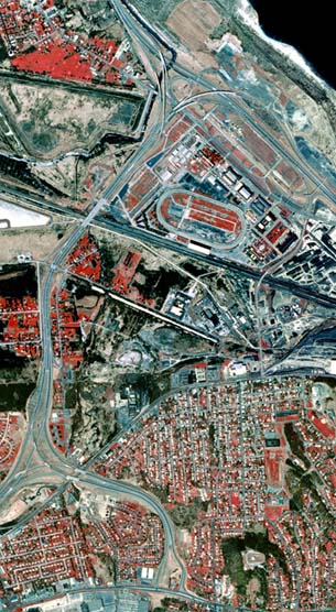
Both I-690 and NY 5 are expressways, as is NY 695. It has only one exit, southbound only to Gere Lock Road. The route also has one northbound only entrance from Milton Avenue (NY 297) via Horan Road. All 2.30 miles (3.70 km) of its existence can seen in this aerial photo. It is the vertical road just left of the center of the image.
Route description
NY 695 begins at a directional T interchange with NY 5 north of the hamlet of Fairmount in the town of Camillus. The route heads north as a six-lane limited-access highway, roughly paralleling the western limits of Syracuse, as it continues on through Camillus. Roughly 0.7 miles (1.1 km) from where NY 695 splits off of NY 5 east, a ramp from Horan Road, a local road that runs alongside NY 695 between Fairmount and Gere Lock Road, merges with NY 695 northbound, providing access to the expressway from Milton Avenue (NY 297). NY 695 passes over Gere Lock Road 0.4 miles (0.6 km) later. There is no access between Gere Lock Road and the expressway on NY 695 northbound; southbound, there is a lone exit ramp leading to the local roadway.[4]
Past Gere Lock Road, NY 695 turns northeast as it ascends to cross over the CSX Transportation-owned Mohawk Subdivision (here four tracks wide) by way of a large flyover 247.4 metres (812 ft) in length.[4][5] The remainder of the route is situated on an embankment as it passes adjacent to the New York State Fairgrounds off to the east of the roadway. Near the northwestern edge of the fairgrounds, NY 695 terminates at a semi-directional T interchange with I-690 (exit 6).[4]
History
Construction on what is now NY 695 began in the early 1970s[6][7] and was completed in the mid-1970s.[8][9] The expressway was initially designated NY 930T, an unsigned reference route.[10] It was redesignated as the signed NY 695 in the early 1980s.[2][3]
Exit list
The entire route is in Onondaga County. All exits are unnumbered.
| Location | mi[1] | km | Destinations | Notes | |
|---|---|---|---|---|---|
| Town of Camillus | 0.00 | 0.00 | |||
| Gere Lock Road (CR 220) | Southbound exit and northbound entrance (via Horan Road) | ||||
| Geddes | 2.30 | 3.70 | |||
| 1.000 mi = 1.609 km; 1.000 km = 0.621 mi | |||||
See also
.svg.png) New York Roads portal
New York Roads portal
References
- 1 2 "2008 Traffic Volume Report for New York State" (PDF). New York State Department of Transportation. June 16, 2009. p. 230. Retrieved January 31, 2010.
- 1 2 I Love New York Tourism Map (Map). Cartography by Rand McNally and Company. State of New York. 1981.
- 1 2 New York (Map). Rand McNally and Company. 1985. ISBN 0-528-91040-X.
- 1 2 3 Google (March 24, 2008). "New York State Route 695" (Map). Google Maps. Google. Retrieved March 24, 2008.
- ↑ Federal Highway Administration (2008). "Structure 1093389". National Bridge Inventory. United States Department of Transportation. Retrieved March 24, 2008.
- ↑ New York Thruway (Map). Cartography by Rand McNally and Company. New York State Thruway Authority. 1971.
- ↑ New York (Map) (1973 ed.). Cartography by H.M. Gousha Company. Shell Oil Company. 1973.
- ↑ New York and New Jersey Tourgide Map (Map). Cartography by Rand McNally and Company. Gulf. 1974.
- ↑ New York (Map) (1977–78 ed.). Cartography by General Drafting. Exxon. 1977.
- ↑ Perry, N.W. "NYS Reference Routes – Region 3". Empire State Roads. Retrieved March 24, 2008.
External links
- New York State Route 695 at New York Routes • New York State Highway Termini • Upstate New York Roads
- NY 5 & NY 695 Interchange, Fairmount