New York State Route 159
| ||||
|---|---|---|---|---|
|
Map of Schenectady County in eastern New York with NY 159 highlighted in red | ||||
| Route information | ||||
| Maintained by NYSDOT | ||||
| Length: | 13.52 mi[1] (21.76 km) | |||
| Existed: | 1930[2] – present | |||
| Major junctions | ||||
| West end: |
| |||
| East end: |
| |||
| Location | ||||
| Counties: | Schenectady | |||
| Highway system | ||||
| ||||

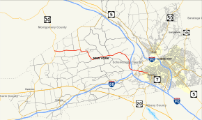
New York State Route 159 (NY 159) is a state highway in New York, running from the town of Duanesburg through Mariaville Lake to the hamlet of Rotterdam, just outside the city of Schenectady. A two-lane highway for all of its length, it is entirely located in Schenectady County.
Route description
Known as Mariaville Road, NY 159 begins at NY 30 just south of the Montgomery County line. Three miles in, it meets NY 160 at its southern terminus, turning right to meet Mariaville Lake. At a signal-controlled intersection with Batter Street, NY 159 turns a hard left to run along the lake's northern shore before turning a hard right to cross over the lake. After heading south for about a mile past the lake, NY 159 turns eastward. Three miles later, a long gentle curve toward a more southerly direction has it heading downhill until another turn takes it to its Thruway overpass.[3]
From there, NY 159 is nearly straight and nearly eastward, crossing NY 337 in Rotterdam and ending at the complex intersection, locally known as the "Rotterdam Five Corners". Also at this intersection is Broadway for Schenectady, Princetown Road, Duanesburgh Road (NY 7 West), and Curry Road (NY 7 East).[3]
History
NY 159 was assigned to its current alignment as part of the 1930 renumbering of state highways in New York and has not had any major changes since.[2]
Major intersections
The entire route is in Schenectady County.
| Location | mi[1] | km | Destinations | Notes | |
|---|---|---|---|---|---|
| Duanesburg | 0.00 | 0.00 | |||
| 3.20 | 5.15 | Hamlet of Mariaville Lake; southern terminus of NY 160 | |||
| Town of Rotterdam | 12.22 | 19.67 | |||
| 13.52 | 21.76 | Hamlet of Rotterdam; Rotterdam Five Corners | |||
| 1.000 mi = 1.609 km; 1.000 km = 0.621 mi | |||||
See also
.svg.png) New York Roads portal
New York Roads portal
References
- 1 2 "2008 Traffic Volume Report for New York State" (PDF). New York State Department of Transportation. June 16, 2009. p. 175. Retrieved February 1, 2010.
- 1 2 Road Map of New York (Map). Cartography by General Drafting. Standard Oil Company of New York. 1930.
- 1 2 Google (March 24, 2008). "overview map of NY 159" (Map). Google Maps. Google. Retrieved March 24, 2008.
External links
- New York State Route 159 at New York Routes • New York State Highway Termini