New Hampshire Route 45
| ||||
|---|---|---|---|---|
|
Map of Hillsborough County in southern New Hampshire with NH 45 highlighted in red | ||||
| Route information | ||||
| Maintained by NHDOT | ||||
| Length: | 5.981 mi[1] (9.625 km) | |||
| Major junctions | ||||
| South end: |
| |||
| North end: |
| |||
| Location | ||||
| Counties: | Hillsborough | |||
| Highway system | ||||
| ||||

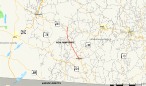
New Hampshire Route 45 is a 5.981-mile-long (9.625 km) north–south state highway in southern New Hampshire. It runs from Greenville to Temple.
Route description
NH 45 begins at NH 123 in Greenville. It runs northwest into the town of Temple where it ends at NH 101.
In Temple, the highway is named Senator Tobey Highway. In Greenville, the road starts as Main Street at the center of town. At the north end of town, the road becomes Temple Road then becomes Greenville-Temple Highway farther north.
Junction list
The entire route is in Hillsborough County. [1][2]
| Location[1][2] | mi[1][2] | km | Destinations | Notes | |
|---|---|---|---|---|---|
| Greenville | 0.000 | 0.000 | Southern terminus | ||
| Temple | 5.981 | 9.625 | Northern terminus | ||
| 1.000 mi = 1.609 km; 1.000 km = 0.621 mi | |||||
References
- 1 2 3 4 Bureau of Planning & Community Assistance (February 20, 2015). "NH Public Roads". Concord, New Hampshire: New Hampshire Department of Transportation. Retrieved April 7, 2015.
- 1 2 3 Bureau of Planning & Community Assistance (April 3, 2015). "Nodal Reference 2015, State of New Hampshire". New Hampshire Department of Transportation. Retrieved April 7, 2015.
External links
This article is issued from Wikipedia - version of the 10/3/2016. The text is available under the Creative Commons Attribution/Share Alike but additional terms may apply for the media files.