Nevada State Route 158
| ||||
|---|---|---|---|---|
| Deer Creek Road | ||||
|
Nevada State Route 158, highlighted in red | ||||
| Route information | ||||
| Maintained by NDOT | ||||
| Length: | 8.882 mi[1] (14.294 km) | |||
| Existed: | 1976 – present | |||
| Major junctions | ||||
| South end: |
| |||
| North end: |
| |||
| Location | ||||
| Counties: | Clark | |||
| Highway system | ||||
| ||||

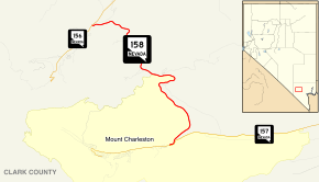
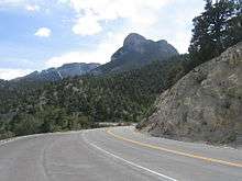
State Route 158 (SR 158), also known as Deer Creek Road, is a state highway in Clark County, Nevada. The route connects Kyle Canyon Road to Lee Canyon Road in the Spring Mountains, in the Humboldt-Toiyabe National Forest.
State Route 158 is a designated a Nevada Scenic Byway.
Route description
_near_Las_Vegas%2C_Nevada.jpg)

The route begins at an intersection with Kyle Canyon Road (SR 157) east of Mount Charleston. Heading north as the Deer Creek Road, SR 158 parallels the Humboldt-Toiyabe National Forest boundary before entering the forest. The highway ends at a junction with Lee Canyon Road (SR 156).[2]
History

The Nevada Department of Transportation designated State Route 156 as a Nevada Scenic Byway in July 1998. The "Deer Creek Road" scenic route encompasses the entire 8.8-mile (14.2 km) highway.[3]
Major intersections
The entire route is in Clark County.
| Location | mi[4] | km | Destinations | Notes | |
|---|---|---|---|---|---|
| Mount Charleston | 0.00 | 0.00 | |||
| | 8.86 | 14.26 | |||
| 1.000 mi = 1.609 km; 1.000 km = 0.621 mi | |||||
See also
 Nevada portal
 U.S. Roads portal
References
| Wikimedia Commons has media related to Nevada State Route 158. |
- ↑ "State Maintained Highways of Nevada: Descriptions and Maps - Quarter 2 Update". Nevada Department of Transportation. July 2011. Retrieved 4 Oct 2011.
- ↑ Google (May 14, 2011). "SR 158" (Map). Google Maps. Google. Retrieved May 14, 2011.
- ↑ Nevada Department of Transportation. "Nevada's Scenic Byways". Retrieved 2010-01-09.
- ↑ Maps of Milepost Location on Nevada's Federal and State Highway System by County (PDF). Nevada Department of Transportation. May 2008. Archived (PDF) from the original on August 10, 2009. Retrieved 2009-08-10.