Bezirk Neubrandenburg
| District of Neubrandenburg Bezirk Neubrandenburg | |||||
| District (Bezirk) of East Germany | |||||
| |||||
 | |||||
| Capital | Neubrandenburg 53°30′N 13°30′E / 53.500°N 13.500°ECoordinates: 53°30′N 13°30′E / 53.500°N 13.500°E | ||||
| History | |||||
| • | Established | 1952 | |||
| • | Disestablished | 1990 | |||
| Area | |||||
| • | 1989 | 10,948 km2 (4,227 sq mi) | |||
| Population | |||||
| • | 1989 | 620,500 | |||
| Density | 56.7 /km2 (146.8 /sq mi) | ||||
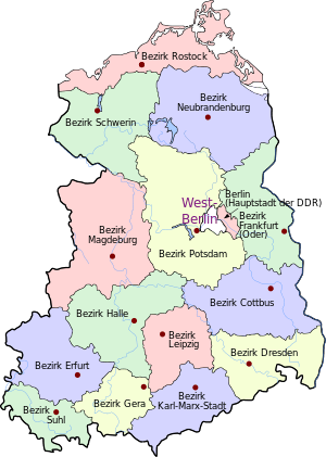
The Bezirk Neubrandenburg was a district (Bezirk) of East Germany. The administrative seat and the main town was Neubrandenburg.
History
The district was established, with the other 13, on July 25, 1952, substituting the old German states. After October 3, 1990, it was disestablished due to the German reunification, becoming again mostly part of the state of Mecklenburg-Vorpommern. Also rural districts of Prenzlau and Templin (on 3 October 1990), municipalities of Nechlin, Wollschow, Woddow, Bagemühl and Grünberg with city of Brüssow in Pasewalk district and municipalities of Fahrenholz, Güterberg, Jagow, Lemmersdorf, Lübbenow, Milow, Trebenow, Wilsickow, Wismar (Uckerland) and Wolfshagen in Strasburg one part of the one of Brandenburg on 9 May 1992.
Geography
Position
The Bezirk Neubrandenburg bordered with the Bezirke of Rostock, Schwerin, Potsdam and Frankfurt (Oder). It bordered also with Poland and a little part of it was located by the Stettin Bay, a lagoon separated from the Baltic Sea.
Subdivision
The Bezirk was divided into 15 Kreise: 1 urban district (Stadtkreis) and 14 rural districts (Landkreise):
- Urban districts : Neubrandenburg.
- Rural districts : Altentreptow; Anklam; Demmin; Malchin; Neubrandenburg-Land; Neustrelitz; Pasewalk; Prenzlau; Röbel/Müritz; Strasburg; Templin; Teterow; Ueckermünde; Waren.
Additional information
Neubrandenburg's vehicle registration plate letter was C.
References
External links
![]() Media related to Bezirk Neubrandenburg at Wikimedia Commons
Media related to Bezirk Neubrandenburg at Wikimedia Commons