Negros Oriental
| Negros Oriental | |||
|---|---|---|---|
| Province | |||
| Province of Negros Oriental | |||
|
Negros Oriental Provincial Capitol in Dumaguete | |||
| |||
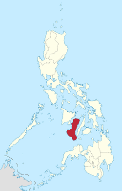
 Location in the Philippines | |||
| Coordinates: 9°45′N 123°00′E / 9.75°N 123°ECoordinates: 9°45′N 123°00′E / 9.75°N 123°E | |||
| Country | Philippines | ||
| Region | Negros Island Region (NIR/Region XVIII) | ||
| Founded | 1 January 1890 | ||
| Capital | Dumaguete | ||
| Government | |||
| • Type | Sangguniang Panlalawigan | ||
| • Governor | Roel Degamo (PDP-Laban) | ||
| • Vice Governor | Mark Macias (Liberal Party) | ||
| • Provincial Board | Negros Oriental Provincial Board | ||
| Area[1] | |||
| • Total | 5,385.53 km2 (2,079.36 sq mi) | ||
| Area rank | 17th out of 81 | ||
| Population (2015 census)[2] | |||
| • Total | 1,354,995 | ||
| • Rank | 19th out of 81 | ||
| • Density | 250/km2 (650/sq mi) | ||
| • Density rank | 35th out of 81 | ||
| Divisions | |||
| • Independent cities | 0 | ||
| • Component cities | |||
| • Municipalities | |||
| • Barangays | 557 | ||
| • Districts | 1st to 3rd districts of Negros Oriental | ||
| Time zone | PST (UTC+8) | ||
| ZIP code | 6200–6224 | ||
| ISO 3166 code | PH-NER | ||
| Spoken languages | |||
| Income classification | 1st class | ||
| Website |
www | ||


Negros Oriental (Cebuano: Sidlakang Negros; Hiligaynon: Negros Sidlangan; Filipino: Silangang Negros), also called Oriental Negros or Eastern Negros, is a province in the Philippines located in the Negros Island Region. It occupies the southeastern half of the island of Negros, with Negros Occidental comprising the northwestern half. It also includes Apo Island, a popular dive site for both, local and foreign tourists.
Negros Oriental faces Cebu to the east across the Tañon Strait and Siquijor to the south-east (which happened to be part of the province before). The primary spoken language is Cebuano and the predominant religious denomination is Roman Catholicism. Dumaguete City is the capital, seat of government and most populous city of the province. With a population of 1,354,995 inhabitants, it is the second most-populous province in Negros Island Region after Negros Occidental, the fifth most-populous province in the Visayas and the 24th most-populous province of the Philippines.
History
Negros Island, the fourth largest island in the Philippines, is believed to have once been part of a larger landmass, but was cut off by rising waters at the end of the last ice age.[3] Among the early inhabitants of the island were Negritos and later the Malays, as well as Han Chinese, who are mainly merchants.[4] They called the island "Buglas", a native word which is believed to mean "cut off".[5]
Spanish explorers on the expedition of Miguel Lopez de Legazpi first came to the island in April 1565. Legazpi dropped anchor in Bohol and sent his men to scout the island.[4] Because of the strong currents of the Tañon Strait between Cebu and Negros, they were carried for several days and forced to land on the western side of the island. They reported seeing many dark-skinned inhabitants, and they called the island "Negros" (Negro means "black" in Spanish). The island was sparsely settled at the time, except for a few coastal settlements including Ilog and Binalbagan. In 1571, Legaspi assigned encomiendas on the island to 13 of his men.[4] Augustinian friars began the Christianization of the island the next year. The island was administered as part of the jurisdiction of Oton until 1734 when it became a military district, and Ilog became the capital of the island. The capital was transferred to Himamaylan in 1795. Negros became a politico-military province in 1865 and the capital was transferred to Bacolod.
Due to its proximity to Mindanao, the southeastern coasts of Negros was in constant threat from Moro marauders looking for slaves, so watchtowers were built to protect the Christian villages. The Moro raids and Negros Oriental's distance from the Negros capital of Bacolod induced 13 Recollectionist priests to petition for the division of the island in July 1876.[4] The island of Negros was then divided into the provinces of Negros Oriental and Negros Occidental by a royal decree executed by Governor General Valeriano Weyler on January 1, 1890. Dumaguete was made the first capital of Negros Oriental. In 1892, Siquijor became a part of Negros Oriental, having previously been administered by Spain under the politico-military province of Bohol.
The Philippine Revolution reached the province in 1898, disrupting government functions but without bloodshed. Revolutionary troops in the province were composed mostly of farm laborers and other prominent people of the Negros Oriental province who were organized and led by Don Diego de la Viña. The Spanish government in Dumaguete was overthrown on November 24, 1898. Later, the Negros Occidental area under the leadership of Gen. Araneta only, in contrast to the Negros Oriental area under the leadership of Don Diego de la Viña, formed the Cantonal Republic of Negros, a separate government from the more familiar Malolos Republic established in Luzon.[6] In 1901 the Negros Oriental province was reorganized by the United States and a civil government was established with Demetrio Larena as governor. The American government made Siquijor a "sub-province" of Negros Oriental. Negros Oriental became a province under the American civil government on March 10, 1917 through Act 2711.[7] In 1934 Negros Oriental became a corregimiento, a separate military district. Under the American colonial government, transportation infrastructure was developed with improvements of roads and new bridges.[8]
During World War II, the province was invaded by Japanese forces and many residents were forced to flee to the mountains.[9] Negros Island was liberated by combined Filipino & American troops with the local Negrense guerillas attacking the Japanese on August 6, 1945. The 7th, 73rd, 74th and 75th Infantry Divisions of the Philippine Commonwealth Army were established from January 3, 1942 to June 30, 1946 and the 7th Infantry Regiment of the Philippine Constabulary was active from October 28, 1944 to June 30, 1946 at the Military General Headquarters in Negros Oriental. They started the engagements of the Anti-Japanese Imperial Military Operations in Negros Oriental from 1942 to 1945 against the Japanese Imperial forces.
On September 17, 1971, Siquijor finally became an independent province by virtue of Republic Act No. 6396.[10]
Negros Oriental was separated from Central Visayas and transferred to the newly created Negros Island Region along with Negros Occidental in 2015, when President Benigno Aquino III signed Executive Order No. 183, s. 2015.[11]
Geography
%2C_Negros_Oriental%2C_Philippines_01.JPG)
Negros Oriental occupies the south-eastern half of the island of Negros, with Negros Occidental comprising the north-western half. It has a total land area of 5,385.53 km2 (2,079.36 sq mi). A chain of rugged mountains separates Negros Oriental from Negros Occidental. Negros Oriental faces Cebu to the east across the Tañon Strait and Siquijor to the southeast. The Sulu Sea borders it to the south to southwest.
Topography
The province's topography is characterized by low, grooved mountain ranges of which some lie close to the shoreline. At the southern end of the province is Mount Talinis, also known as Cuernos de Negros ("Horns of Negros"), which is a dormant complex volcano which rises to a height of 2,000 metres (6,600 ft). At the northern end of the province is the active Kanlaon Volcano, the highest peak of the island region with a height of 2,465 metres (8,087 ft). There are a few flatlands and plateaus in the interior to the southwest of the province, which includes the Tablas Plateau.[12]
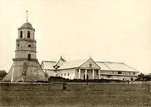
One of the landmarks of Dumaguete is the Dumaguete Bell Tower which stands next to the Saint Catherine of Alexandria Cathedral.[13] It once used to warn the city of impending pirate attacks.[14]
Climate
Negros Oriental has a tropical climate. Because of the mountain range running from the north to the south, the province has two types of climatic conditions.[15] The eastern part of the province is characterized by unpronounced maximum rainfall with a short dry season lasting from one to three months. The western half of the province is characterized by a distinct wet season and dry season.[12]

Administrative divisions
Negros Oriental comprises 19 municipalities and 6 cities, further subdivided into 557 barangays.
Dumaguete City is the provincial capital and seat of government. It is also the province's most populous city, despite having the smallest land area among all component cities and municipalities of Negros Oriental.
For purposes of legislative representation, the cities and municipalities are grouped into three congressional districts, with each district electing a congressman to the House of Representatives of the Philippines.
- † Provincial capital and component city
- ∗ Component city
- Municipality
| ||||||||||||||||||||||||||||||||||||||||||||||||||||||||||||||||||||||||||||||||||||||||||||||||||||||||||||||||||||||||||||||||||||||||||||||||||||||||||||||||||||||||||||||||||||||||||||||||||||||||||||||||||||||||||||||||||||||||||||||||||||||||||||||||||||||||||||||||||||||||||||||||||||||||||||||||||||||||||||||||||||||||||||||||||||||||||||||||||||||||||||||||||
Demographics
| Population census of Negros Oriental | ||
|---|---|---|
| Year | Pop. | ±% p.a. |
| 1990 | 925,272 | — |
| 1995 | 1,025,247 | +1.94% |
| 2000 | 1,130,088 | +2.11% |
| 2007 | 1,231,904 | +1.20% |
| 2010 | 1,286,666 | +1.60% |
| 2015 | 1,354,995 | +0.99% |
| Source: Philippine Statistics Authority[2][17][20] | ||
The population of Negros Oriental in the 2015 census was 1,354,995 people,[2] with a density of 250/km2 (650/sq mi). Its registered voting population are 606,634.[22] 34.5% of the population are concentrated in the six most populous component cities of Dumaguete, Bayawan, Guihulngan, Tanjay, Bais and Canlaon. Population growth per year is about 0.99% over the period of 2010-2015, lower than the national average of 1.72%.[2]
Residents of Negros are called "Negrenses" (and less often "Negrosanons") and many are of either pure/mixed Austronesian heritage, with foreign ancestry as minorities. Negros Oriental is predominantly a Cebuano-speaking province by 72%, due to its close proximity to Cebu. Hiligaynon/Ilonggo is spoken by the remaining 28% and is common in areas close to the border with Negros Occidental. Filipino and English, though seldom used, are generally understood and used for official, literary and educational purposes.
Religion
Christianity is the predominant religion in the province with Roman Catholicism (91.4%) as the largest single denomination. Other denominations include mainline and evangelical Protestant groups, the Iglesia Ni Cristo, the Seventh-day Adventists, Jehovah's Witnesses and the Aglipayan Church, also known as the Philippine Independent Church. Adherents of Islam and Buddhism constitute a minority of the population.
Economy
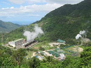
Negros Oriental has, for a long time, been a major supplier of electricity to its neighboring provinces in the Visayas with its excess power capacity generated by the 192.5-MW Palinpinon geothermal plant.[23] This plant has recently been expanded with an additional 49MW capacity, bringing total power output of the province to over 240MW. Despite the huge power excess of the Province, other power sources such as hydro, wind and solar are being explored to provide additional power capacities that can be sold to neighboring areas.
With its vast fertile land resources, Negros Oriental's other major industry is agriculture. The primary crops are sugarcane, sweetcorn, coconut and rice.[12] In the coastal areas, fishing is the main source of income. People are also involved in cattle ranches, fish ponds and rubber plantations, especially in Bayawan City. There are also mineral deposits like gold, silver and copper found throughout the province.
The province is already emerging as a major technological center in Visayas, with its growing business process outsourcing (BPO) that has started to penetrate the province's secondary cities and other technology-related industries. Vehicle assembly is a growing industry in Amlan. Construction of mass housing and subdivisions is very evident in the periphery of Dumaguete City and is expected to spillover into the province's secondary cities and fast-growing towns. Other industries include water bottling and warehousing, as well as cold and dry storing. Retailing has penetrated other urban areas outside Dumaguete, with the entry of supermarkets and shopping malls in cities such as Bayawan, Tanjay and Bais. The town of Bacong, which borders Dumaguete in the south, hosts many industrial plants geared for the local and export markets, which can bolster economic growth. Negros Oriental is also a notable tourist destination in the Visayas.
Transportation

Negros Oriental has a network of roads, including a national road that spans the circumference of Negros Island. National and provincial roads in the province total more than 900 kilometers, though only about half of these are paved.[24]
A large portion of residents do not own private vehicles, and are totally reliant on public transport. The main form of public transport between the cities and municipalities of the province largely consists of privately operated jeepneys that link major towns to rural areas. For short distances within a town, motorized tricycles (locally known as pedicabs) are available.
The Dumaguete Airport located in Sibulan is the province's only government-operated airport.[24] It is a domestic airport with multiple daily flights to and from Manila, served by Philippine Airlines and Cebu Pacific. Based on 2002 statistics, an average of 5,800 outgoing passengers and 5,700 incoming passengers pass through the airport every month. However, this airport is due for transfer to Bacong because of congestion in its current location.[24]
The primary seaport of the province is located in Dumaguete City. Additionally, there are five other seaports in the province classified as tertiary.[25]
Education

Dumaguete City, the provincial capital, is known as a university city due to the existence of many universities and colleges in the city.[26] These universities include: Silliman University (1901), the oldest American established university in Asia;[27] St. Paul University Dumaguete (1904), the first Paulinian school in the Philippines and oldest catholic school in Negros Island known for its Nursing, Tourism, Liberal Arts in History and English, Public Administration, Mass Communication, Business Administration and Education; Negros Oriental State University (formerly NOTS-1927, EVSAT, CVPC); and Foundation University (1949). The Colegio de Sta. Catalina De Alejandria (COSCA), Negros Oriental High School (1902), Ramon Teves Pastor Memorial-Dumaguete Science High School (1986), Dumaguete City High School (1967), Catherina Cittadini (St. Louis) School, Holy Cross High School and St. Louis School-Don Bosco (1967) can be also found in the city. There are also institutions and colleges inside (e.g. Metro Dumaguete College, STI, Maxino College, PTC, AMA Computer College, Asian College) and outside the city.
Culture
Each town in Negros Oriental celebrates an annual town fiesta, usually dedicated to a patron saint of a particular town or city. In some of the larger towns, there are particular fiestas for specific neighborhoods or barangays.
Additionally, the Buglasan Festival, which was revived in 2001, is celebrated annually in October in the provincial capital of Dumaguete and is hailed as Negros Oriental's "festival of festivals".[28] It is a week-long celebration where you can see unique booths of each town and city in Negros Oriental featuring their native products and tourist attractions. The highlight of the occasion is the float parade and street dancing competition.[29]
Media
There are at least six local publications in general circulation around the province. These publications include the Dumaguete MetroPost,[30] The Negros Chronicle,[31] Dumaguete Star Informer, Times Focus, Island News and The Visayan Daily Star.[32] Sun.Star Dumaguete publishes news online bi-weekly. PLDT, Globe Telecom and their subsidiaries are major providers of network connection within the province. Major providers, in TV and radio are ABS-CBN, GMA, TV5 and CNN. Cable TV provides access to BBC, ESPN and other international programs. The province is mainly served by two regional newscasts: TV Patrol Negros (ABS-CBN Dumaguete, shared with ABS-CBN Bacolod) and TV Patrol Central Visayas (shared with ABS-CBN Cebu).
References
- ↑ "List of Provinces". PSGC Interactive. Makati City, Philippines: National Statistical Coordination Board. Archived from the original on 2013-01-21. Retrieved 11 March 2013.
- 1 2 3 4 5 Census of Population (2015): Highlights of the Philippine Population 2015 Census of Population (Report). PSA. Retrieved 20 June 2016.
- ↑ "Files Magazine". Panay News. Archived from the original on 18 December 2005. Retrieved 22 July 2016.
- 1 2 3 4 WOW Philippines - Negros Oriental history Archived August 19, 2004, at the Wayback Machine.
- ↑ "Files Magazine". Panay News. Archived from the original on 18 December 2005. Retrieved 22 July 2016.
- ↑ "Republic of Negros". World Statesmen.org. Retrieved 22 July 2016.
- ↑ "An Act Amending the Administrative Code" (PDF). Official Gazette of the Republic of the Philippines. 10 March 1917. Retrieved 23 April 2016.
The Province of Oriental Negros consists of territory in the south and eastern part of the Island of Negros, with adjacent small islands, and includes also the subprovince of Siquijor, which consists of the island of the same name. The province contains the following municipalities: Ayungon, Ayuquitan, Bacong, Bais, Dauin, Dumaguete (the capital of the province), Enrique Villanueva, Guijulñgan, Jimalalud, La Libertad, Larena, Lazi, Luzuriaga, Manjuyod, Maria, San Juan, Siaton, Sibulan, Siquijor, (Talingting), Tanjay, Tayasan, Tolong, Vallehermoso, and Zamboanguita. This province also contains the municipal district of Tambo.
- ↑ "Major Hubs 5 Major Destinations". Asia-planet.net. Retrieved 22 July 2016.
- ↑ Mills, S.A., 2009, Stranded in the Philippines, Annapolis: Naval Institute Press, ISBN 9781591144977
- ↑ "Republic Act No. 6398 - An Act Separating the Subprovince of Siquijor from the Province of Oriental Negros and Establishing It as an Independent Province". Chan Robles Virtual Law Library. 17 September 1971. Retrieved 16 April 2016.
- ↑ "Executive Order No. 183; Creating a Negros Island Region and for Other Purposes". Official Gazette of the Republic of the Philippines. Malacañan Palace, Manila, Philippines. 29 May 2015. Retrieved 8 July 2016.
- 1 2 3 "Negros Oriental Provincial Agricultural Profile" (PDF). Department of Agriculture - Agriculture and Fisheries Market Information System (AFMIS). 2011. Retrieved 23 April 2016.
- ↑ "Dumaguete Belfry - Philippines". Dumaguete Info: the Website of Gentle People. Retrieved 2008-04-06.
- ↑ Grele, Dominique; Lily Yousry-Jouve (2004). 100 Resorts in the Philippines: Places with a Heart. Asiatype, Inc. p. 247. ISBN 978-971-91719-7-3. Retrieved 2008-04-05.
- ↑ "Climate Condition". Agribiz Oriental. Retrieved 22 July 2016.
- 1 2 "Province: Negros Oriental". PSGC Interactive. Quezon City, Philippines: Philippine Statistics Authority. Retrieved 8 January 2016.
- 1 2 "Region VII (CENTRAL VISAYAS)". Census of Population and Housing (2010): Total Population by Province, City, Municipality and Barangay (Report). NSO. Retrieved 29 June 2016.
- ↑ Gallarde, Juancho R. (30 August 2013). "In Negros Oriental: Valencia town readies bid to become a city". The Philippine Star. Retrieved 3 January 2016.
- ↑ Camion, Victor L. (21 November 2013). "House to hear Valencia cityhood". Sun.Star Dumaguete. Archived from the original on 24 November 2013. Retrieved 3 January 2016.
- ↑ Census of Population and Housing (2010): Population and Annual Growth Rates for The Philippines and Its Regions, Provinces, and Highly Urbanized Cities (PDF) (Report). NSO. Retrieved 29 June 2016.
- ↑ "Negros Oriental: More Than One-Third of the Houses Were Built in the Latter 90's (Results from the 2000 Census of Population and Housing, NSO); Table 4. Household Population by Ethnicity and Sex: Negros Oriental, 2000". Philippine Statistics Authority. 9 September 2002. Retrieved 23 April 2016.
- ↑ "Region: NIR - Negros Island Region". Philippine Statistics Authority. Retrieved 22 July 2016.
- ↑ Gatdula, Donnabelle L. (26 October 2009). "EDC takes over Tongonan, Palinpinon geothermal plants". The Philippine Star. Retrieved 23 April 2016.
- 1 2 3 "Transportation". Agribiz Oriental. Retrieved 22 July 2016.
- ↑ "Negros Oriental". Department of Trade and Industry. Archived from the original on 6 October 2003. Retrieved 23 April 2016.
- ↑ Bangayan, Dorothy (2006-12-14). "Let's do Dumaguete!". Sun.Star Davao. Archived from the original on 25 November 2007. Retrieved 2008-04-06.
...Dumaguete is also known as a university town due to the numerous colleges including their famous Silliman.
- ↑ Dexter R. Matilla. "Heritage diary of Negros Oriental". Philippine Daily Inquirer. Retrieved 2009-12-30.
- ↑ Amarado, Romy G. (25 October 2003). "The 'fantastic' Buglasan Festival of Dumaguete". Philippine Daily Inquirer. Dumaguete City, Philippines. Inquirer News Service. Archived from the original on 30 August 2005. Retrieved 23 April 2016.
- ↑ "Buglasan Festival 2015 opens with 'Fiesta sa Nayon'". Sun.Star Dumaguete. Philippine Information Agency. 11 August 2015. Retrieved 23 April 2016.
- ↑ "Visayan News". Dumaguete MetroPost. Retrieved 16 April 2016.
- ↑ "(Home page)". The Negros Chronicle. Retrieved 16 April 2016.
- ↑ "Negros Oriental (home page)". The Visayan Daily Star. Retrieved 16 April 2016.
External links
-
 Negros Oriental travel guide from Wikivoyage
 -
 Media related to Negros Oriental at Wikimedia Commons
 -
 Geographic data related to Negros Oriental at OpenStreetMap
 - Official Website of the Provincial Government of Negros Oriental
- Local Governance Performance Management System
 |
Negros Occidental | | ||
| Negros Occidental | |
Tañon Strait / Cebu | ||
| ||||
| | ||||
| Sulu Sea Zamboanga del Norte |
Bohol Sea / Siquijor |
Dumaguete (capital) | |
| Municipalities | |
| Component cities | |