Naujan, Oriental Mindoro
| Naujan | ||
|---|---|---|
| Municipality | ||
 | ||
| ||
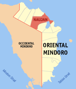 Map of Oriental Mindoro with location of Naujan | ||
.svg.png) Naujan Location within the Philippines | ||
| Coordinates: 13°19′N 121°18′E / 13.317°N 121.300°ECoordinates: 13°19′N 121°18′E / 13.317°N 121.300°E | ||
| Country | Philippines | |
| Region | MIMAROPA (Region IV-B) | |
| Province | Oriental Mindoro | |
| Congr. district | 1st district | |
| Founded | 1693 | |
| Incorporated | 1905 | |
| Barangays | 70 | |
| Government[1] | ||
| • Mayor | Atty. Mark Navarro Marcos | |
| Area[2] | ||
| • Total | 503.10 km2 (194.25 sq mi) | |
| Population (2010)[3] | ||
| • Total | 94,497 | |
| • Density | 190/km2 (490/sq mi) | |
| Time zone | PST (UTC+8) | |
| ZIP code | 5204 | |
| Dialing code | 43 | |

Naujan is a first class municipality in the province of Oriental Mindoro, Philippines. It covers a land area of 50,310 hectares (124,300 acres), making it the largest municipality in the province and accounting for 12% of the province’s total land area. It assumed the status of a full-fledged municipality on January 4, 1905 under Act 1280. Its boundaries were permanently established in 1919.
Barangays
Naujan is politically subdivided into 70 barangays.[2]
- Adrialuna
- Antipolo
- Apitong
- Arangin
- Aurora
- Bacungan
- Bagong Buhay
- Bancuro
- Barcenaga
- Bayani
- Buhangin
- Concepcion
- Dao
- Del Pilar
- Estrella
- Evangelista
- Gamao
- General Esco
- Herrera
- Inarawan
- Kalinisan
- Laguna
- Mabini
- Andres Ylagan
- Mahabang Parang
- Malaya
- Malinao
- Malvar
- Masagana
- Masaguing
- Melgar A
- Melgar B
- Metolza
- Montelago
- Montemayor
- Motoderazo
- Mulawin
- Nag-Iba I
- Nag-Iba II (Putol)
- Pagkakaisa
- Paniquian
- Pinagsabangan I
- Pinagsabangan II
- Pinahan
- Poblacion I Barangay I)
- Poblacion II (Barangay II)
- Poblacion III Barangay III)
- Sampaguita
- San Agustin I
- San Agustin II
- San Andres
- San Antonio
- San Carlos
- San Isidro
- San Jose
- San Luis
- San Nicolas
- San Pedro
- Santa Isabel
- Santa Maria
- Santiago
- Santo Nino
- Tagumpay
- Tigkan
- Sta. Cruz
- Balite
- Banuton
- Caburo
- Magtibay
- Papaitan
Demographics
| Population census of Naujan | ||
|---|---|---|
| Year | Pop. | ±% p.a. |
| 1990 | 72,203 | — |
| 1995 | 75,726 | +0.90% |
| 2000 | 83,892 | +2.22% |
| 2007 | 90,629 | +1.07% |
| 2010 | 94,497 | +1.53% |
| Source: National Statistics Office[3] | ||
Local government
2016-2019 Elected officials:[1]
- Municipal Mayor: Atty. Mark N. Marcos
- Vice-Mayor: Sheryl Morales
- Sangguniang Bayan Members:
- Vilma Vargas, Councilor
- Marion Marcos, Councilor
- Aleli Casubuan, Councilor
- Jun Bugarin, Councilor
- Dan Melgar, Councilor
- Toti Arago, Councilor
- Howard Arteza, Councilor
- Neil Bermudez, Councilor
- ABC President
See also
References
- 1 2 "Official City/Municipal 2013 Election Results". Intramuros, Manila, Philippines: Commission on Elections (COMELEC). 11 September 2013. Retrieved 23 December 2013.
- 1 2 "Province: ORIENTAL MINDORO". PSGC Interactive. Makati City, Philippines: National Statistical Coordination Board. Retrieved 30 October 2012.
- 1 2 "Total Population by Province, City, Municipality and Barangay: as of May 1, 2010" (PDF). 2010 Census of Population and Housing. National Statistics Office. Retrieved 30 October 2012.
External links
 |
Calapan City | Sibuyan Sea | | |
| Baco | |
|||
| ||||
| | ||||
| Sablayan, Occidental Mindoro / Victoria | Pola |
Calapan (capital) | |
| Municipalities | |
| Component city | |
This article is issued from Wikipedia - version of the 9/20/2016. The text is available under the Creative Commons Attribution/Share Alike but additional terms may apply for the media files.