National Register of Historic Places listings in Wyoming County, West Virginia
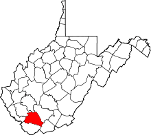
This is a list of the National Register of Historic Places listings in Wyoming County, West Virginia.
This is intended to be a complete list of the properties and districts on the National Register of Historic Places in Wyoming County, West Virginia, United States. The locations of National Register properties and districts for which the latitude and longitude coordinates are included below, may be seen in a Google map.[1]
There are 4 properties and districts listed on the National Register in the county.
- This National Park Service list is complete through NPS recent listings posted December 2, 2016.[2]
Barbour - Berkeley - Boone - Braxton - Brooke - Cabell - Calhoun - Clay - Doddridge - Fayette - Gilmer - Grant - Greenbrier - Hampshire - Hancock - Hardy - Harrison - Jackson - Jefferson - Kanawha - Lewis - Lincoln - Logan - Marion - Marshall - Mason - McDowell - Mercer - Mineral - Mingo - Monongalia - Monroe - Morgan - Nicholas - Ohio - Pendleton - Pleasants - Pocahontas - Preston - Putnam - Raleigh - Randolph - Ritchie - Roane - Summers - Taylor - Tucker - Tyler - Upshur - Wayne - Webster - Wetzel - Wirt - Wood - Wyoming |
Current listings
| [3] | Name on the Register | Image | Date listed[4] | Location | City or town | Description |
|---|---|---|---|---|---|---|
| 1 | Itmann Company Store and Office | |
(#90001775) |
West Virginia Routes 10 and 16 37°34′26″N 81°25′04″W / 37.573889°N 81.417778°W |
Itmann | |
| 2 | Mullens Historic District | 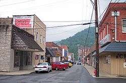 |
(#93001233) |
Roughly bounded by Lusk and Highland Aves., the Norfolk Southern railroad tracks and Water St. 37°34′57″N 81°23′05″W / 37.5825°N 81.384722°W |
Mullens | |
| 3 | Wyco Church | 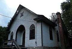 |
(#10000168) |
County Route 12/1, approximately 1 mile north of County Route 16 37°35′56″N 81°20′34″W / 37.5990033°N 81.3428800°W |
Wyco | Community church built in 1917 by coal baron W.P. Tams to serve Wyco Coal Camp C[5] |
| 4 | Wyoming County Courthouse and Jail | 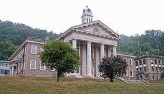 |
(#79002607) |
Main St. 37°35′01″N 81°32′16″W / 37.583611°N 81.537778°W |
Pineville |
See also
| Wikimedia Commons has media related to National Register of Historic Places in Wyoming County, West Virginia. |
- List of National Historic Landmarks in West Virginia
- National Register of Historic Places listings in West Virginia
References
- ↑ The latitude and longitude information provided in this table was derived originally from the National Register Information System, which has been found to be fairly accurate for about 99% of listings. For about 1% of NRIS original coordinates, experience has shown that one or both coordinates are typos or otherwise extremely far off; some corrections may have been made. A more subtle problem causes many locations to be off by up to 150 yards, depending on location in the country: most NRIS coordinates were derived from tracing out latitude and longitudes off of USGS topographical quadrant maps created under the North American Datum of 1927, which differs from the current, highly accurate WGS84 GPS system used by most on-line maps. Chicago is about right, but NRIS longitudes in Washington are higher by about 4.5 seconds, and are lower by about 2.0 seconds in Maine. Latitudes differ by about 1.0 second in Florida. Some locations in this table may have been corrected to current GPS standards.
- ↑ "National Register of Historic Places: Weekly List Actions". National Park Service, United States Department of the Interior. Retrieved on December 2, 2016.
- ↑ Numbers represent an ordering by significant words. Various colorings, defined here, differentiate National Historic Landmarks and historic districts from other NRHP buildings, structures, sites or objects.
- ↑ The eight-digit number below each date is the number assigned to each location in the National Register Information System database, which can be viewed by clicking the number.
- ↑ Steelhammer, Rick (April 17, 2010). "Student volunteers renovating historic Wyco church". Charleston, West Virginia: Saturday Gazette-Mail. Retrieved April 17, 2010.
| Topics |  | |
|---|---|---|
| Lists by county |
| |
| Other lists | ||
| ||
Municipalities and communities of Wyoming County, West Virginia, United States | ||
|---|---|---|
| City | | |
| Towns | ||
| CDPs | ||
| Unincorporated communities |
| |
| Footnotes | ‡This populated place also has portions in an adjacent county or counties | |