| [2] |
Name on the Register[3] |
Image |
Date listed[4] |
Location |
City or town |
Description |
|---|
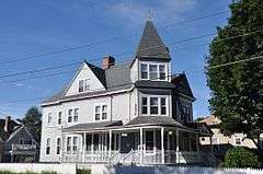
| 1 |
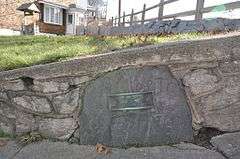
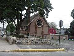
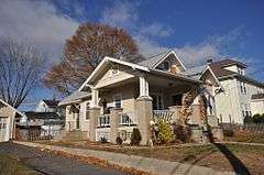
1761 Milestone |
|
000000001982-11-24-0000November 24, 1982
(#82000131) |
640 S. Main St.
41°59′22″N 71°31′54″W / 41.989444°N 71.531667°W / 41.989444; -71.531667 (1761 Milestone) |
Woonsocket |
|
| 2 |
Allen Street Historic District |
|
000000001990-09-13-0000September 13, 1990
(#90001349) |
Allen St.
42°00′06″N 71°30′50″W / 42.001667°N 71.513889°W / 42.001667; -71.513889 (Allen Street Historic District) |
Woonsocket |
|
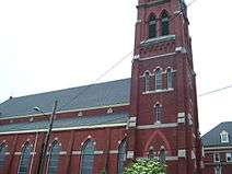
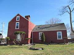
| 3 |
John Arnold House |
|
000000001982-11-24-0000November 24, 1982
(#82000132) |
99 Providence St.
41°59′41″N 71°31′22″W / 41.994722°N 71.522778°W / 41.994722; -71.522778 (John Arnold House) |
Woonsocket |
|
| 4 |
Bernon Worsted Mill |
|
000000002005-06-10-0000June 10, 2005
(#05000585) |
828 Park Ave.
41°59′38″N 71°30′50″W / 41.993889°N 71.513889°W / 41.993889; -71.513889 (Bernon Worsted Mill) |
Woonsocket |
|
| 5 |
Blackstone Canal |
|
000000001971-05-06-0000May 6, 1971
(#71000030) |
From Steeple and Promenade Sts. in Providence to the Massachusetts border in North Smithfield
41°55′16″N 71°25′21″W / 41.921111°N 71.4225°W / 41.921111; -71.4225 (Blackstone Canal) |
Lincoln, Cumberland, Woonsocket, and North Smithfield |
Initial listing extended from Providence, through Pawtucket, and as far north as Lincoln; a 1991 expansion (#91001536) extended it to the state line; the canal itself extended into Worcester County, Massachusetts, where it is the subject of separate listings.
|
| 6 |
Cato Hill Historic District |
|
000000001976-08-10-0000August 10, 1976
(#76002255) |
Bounded by Main, Railroad, Arnold and Blackstone Streets, including portions of Cato, Church, Boyden, and all of Clarkin Lane and Cato Lane
42°00′18″N 71°30′54″W / 42.005°N 71.515°W / 42.005; -71.515 (Cato Hill Historic District) |
Woonsocket |
|
| 7 |
Henry Darling House |
|
000000001982-11-26-0000November 26, 1982
(#82000136) |
786 Harris Ave.
42°00′50″N 71°31′40″W / 42.013889°N 71.527778°W / 42.013889; -71.527778 (Henry Darling House) |
Woonsocket |
|
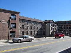
| 8 |
French Worsted Company Mill Historic District |
|
000000002008-05-21-0000May 21, 2008
(#08000453) |
153 Hamlet Ave.
42°00′10″N 71°30′00″W / 42.002764°N 71.499919°W / 42.002764; -71.499919 (French Worsted Company Mill Historic District) |
Woonsocket |
Demolished in 2011.[5]
|
| 9 |
Alphonse Gaulin Jr. House |
|
000000001982-11-24-0000November 24, 1982
(#82000137) |
311 Elm St.
42°00′25″N 71°29′55″W / 42.006944°N 71.498611°W / 42.006944; -71.498611 (Alphonse Gaulin Jr. House) |
Woonsocket |
|
| 10 |
Glenark Mills |
|
000000001989-05-15-0000May 15, 1989
(#89000409) |
64 East St.
41°59′54″N 71°31′09″W / 41.998333°N 71.519167°W / 41.998333; -71.519167 (Glenark Mills) |
Woonsocket |
|
| 11 |
Grove Street Elementary School |
|
000000001982-11-24-0000November 24, 1982
(#82000138) |
312 Grove St.
41°59′54″N 71°30′33″W / 41.998333°N 71.509167°W / 41.998333; -71.509167 (Grove Street Elementary School) |
Woonsocket |
|
| 12 |
Hanora Mills |
|
000000001982-11-24-0000November 24, 1982
(#82000139) |
1 Main St.
42°00′02″N 71°30′58″W / 42.000556°N 71.516111°W / 42.000556; -71.516111 (Hanora Mills) |
Woonsocket |
|
| 13 |
Harris Warehouse |
|
000000001976-07-01-0000July 1, 1976
(#76000047) |
61 Railroad St.
42°00′14″N 71°30′54″W / 42.003889°N 71.515°W / 42.003889; -71.515 (Harris Warehouse) |
Woonsocket |
|
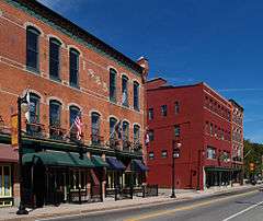
| 14 |
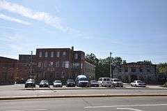
Honan's Block and 112-114 Main Street |
|
000000001989-08-03-0000August 3, 1989
(#89000941) |
110-114 Main St.
42°00′08″N 71°30′53″W / 42.002222°N 71.514722°W / 42.002222; -71.514722 (Honan's Block and 112-114 Main Street) |
Woonsocket |
|
| 15 |
Hope Street School |
|
000000002000-04-14-0000April 14, 2000
(#00000383) |
40 Hope St.
41°59′57″N 71°31′13″W / 41.999167°N 71.520278°W / 41.999167; -71.520278 (Hope Street School) |
Woonsocket |
|
| 16 |
Island Place Historic District |
|
000000001990-09-13-0000September 13, 1990
(#90001348) |
Island Place and S. Main St. at Market Sq.
41°59′57″N 71°30′59″W / 41.999167°N 71.516389°W / 41.999167; -71.516389 (Island Place Historic District) |
Woonsocket |
|
| 17 |
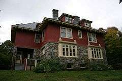
Jenckes Mansion |
|
000000001982-11-24-0000November 24, 1982
(#82000140) |
837-839 Social St.
42°00′44″N 71°30′07″W / 42.012222°N 71.501944°W / 42.012222; -71.501944 (Jenckes Mansion) |
Woonsocket |
|
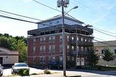
| 18 |
Jules Desurmont Worsted Company Mill |
|
000000002007-01-12-0000January 12, 2007
(#06001257) |
84 Fairmount St.
42°00′09″N 71°31′21″W / 42.0025°N 71.5225°W / 42.0025; -71.5225 (Jules Desurmont Worsted Company Mill) |
Woonsocket |
|
| 19 |
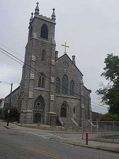
L'Eglise du Precieux Sang |
|
000000001982-07-26-0000July 26, 1982
(#82000142) |
94 Carrington Ave. and 61 Park Ave.
42°00′06″N 71°30′33″W / 42.001667°N 71.509167°W / 42.001667; -71.509167 (L'Eglise du Precieux Sang) |
Woonsocket |
|
| 20 |
Linton Block |
Upload image |
000000001982-11-24-0000November 24, 1982
(#82000143) |
3-5 Monument Sq.
42°00′19″N 71°30′48″W / 42.005278°N 71.513333°W / 42.005278; -71.513333 (Linton Block) |
Woonsocket |
Destroyed by fire in 2000.[6]
|
| 21 |
Logee House |
|
000000001982-11-24-0000November 24, 1982
(#82000001) |
225 Logee St.
41°59′41″N 71°30′43″W / 41.994722°N 71.511944°W / 41.994722; -71.511944 (Logee House) |
Woonsocket |
|
| 22 |
Main Street Historic District |
|
000000001991-04-18-0000April 18, 1991
(#91000461) |
Roughly Main St. east of Market Sq. to Depot Sq.
42°00′09″N 71°30′52″W / 42.0025°N 71.514444°W / 42.0025; -71.514444 (Main Street Historic District) |
Woonsocket |
|
| 23 |
North End Historic District |
|
000000001982-11-24-0000November 24, 1982
(#82000002) |
Roughly bounded by Verry, Highland, Winter, and Summer Sts.
42°00′31″N 71°31′15″W / 42.008611°N 71.520833°W / 42.008611; -71.520833 (North End Historic District) |
Woonsocket |
|
| 24 |
Philmont Worsted Company Mill |
|
000000002006-04-19-0000April 19, 2006
(#06000296) |
685 Social St.
42°00′38″N 71°30′07″W / 42.010556°N 71.501944°W / 42.010556; -71.501944 (Philmont Worsted Company Mill) |
Woonsocket |
|
| 25 |
Pothier House |
|
000000001982-11-24-0000November 24, 1982
(#82000003) |
172 Pond St.
42°00′27″N 71°30′42″W / 42.0075°N 71.511667°W / 42.0075; -71.511667 (Pothier House) |
Woonsocket |
|
| 26 |
St. Andrews Episcopal Chapel |
|
000000001982-11-24-0000November 24, 1982
(#82000005) |
576 Fairmont St.
42°00′03″N 71°31′54″W / 42.000833°N 71.531667°W / 42.000833; -71.531667 (St. Andrews Episcopal Chapel) |
Woonsocket |
|
| 27 |
St. Ann's Church Complex |
|
000000001982-11-24-0000November 24, 1982
(#82000006) |
Cumberland and Elm Sts. and Gaulin Ave.
42°00′27″N 71°30′08″W / 42.0075°N 71.502222°W / 42.0075; -71.502222 (St. Ann's Church Complex) |
Woonsocket |
|
| 28 |
St. Charles Borromeo Church Complex |
|
000000001983-02-24-0000February 24, 1983
(#83000003) |
N. Main, Daniels, and Earle Sts.
42°00′29″N 71°30′52″W / 42.008056°N 71.514444°W / 42.008056; -71.514444 (St. Charles Borromeo Church Complex) |
Woonsocket |
|
| 29 |
Smith-Ballou House |
|
000000002003-06-06-0000June 6, 2003
(#03000184) |
641 Harris Avenue
42°00′45″N 71°31′28″W / 42.0125°N 71.524444°W / 42.0125; -71.524444 (Smith-Ballou House) |
Woonsocket |
|
| 30 |
Smithfield Friends Meeting House, Parsonage & Cemetery |
|
000000001982-11-24-0000November 24, 1982
(#82000008) |
126 Smithfield Rd.
41°59′21″N 71°31′49″W / 41.989167°N 71.530278°W / 41.989167; -71.530278 (Smithfield Friends Meeting House, Parsonage & Cemetery) |
Woonsocket |
|
| 31 |
South Main Street Historic District |
|
000000001982-11-24-0000November 24, 1982
(#82000009) |
Roughly bounded by Mason, Coe, Andrews St., and Bernice Ave.
41°59′37″N 71°31′35″W / 41.993611°N 71.526389°W / 41.993611; -71.526389 (South Main Street Historic District) |
Woonsocket |
|
| 32 |
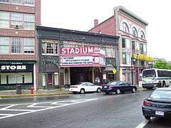
Stadium Building |
|
000000001976-06-30-0000June 30, 1976
(#76000006) |
329 Main St.
42°00′19″N 71°30′46″W / 42.005278°N 71.512778°W / 42.005278; -71.512778 (Stadium Building) |
Woonsocket |
|
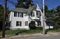
| 33 |
U.S. Post Office |
|
000000001979-05-30-0000May 30, 1979
(#79003774) |
295 Main St.
42°00′17″N 71°30′46″W / 42.004722°N 71.512778°W / 42.004722; -71.512778 (U.S. Post Office) |
Woonsocket |
Now part of YMCA
|
| 34 |
Frank Wilbur House |
|
000000001982-11-24-0000November 24, 1982
(#82000012) |
1273 Park Ave.
41°59′08″N 71°30′59″W / 41.985556°N 71.516389°W / 41.985556; -71.516389 (Frank Wilbur House) |
Woonsocket |
|
| 35 |
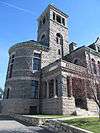
Woonsocket City Hall |
|
000000001974-05-01-0000May 1, 1974
(#74000007) |
169 Main St.
42°00′08″N 71°30′53″W / 42.002222°N 71.514722°W / 42.002222; -71.514722 (Woonsocket City Hall) |
Woonsocket |
|
| 36 |
Woonsocket Civil War Monument |
|
000000001982-11-24-0000November 24, 1982
(#82000013) |
Monument Sq.
42°00′19″N 71°30′47″W / 42.005278°N 71.513056°W / 42.005278; -71.513056 (Woonsocket Civil War Monument) |
Woonsocket |
|
| 37 |
Woonsocket Company Mill Complex |
|
000000001973-05-07-0000May 7, 1973
(#73000005) |
100-115 Front St.
42°00′05″N 71°30′46″W / 42.001389°N 71.512778°W / 42.001389; -71.512778 (Woonsocket Company Mill Complex) |
Woonsocket |
|
| 38 |
Woonsocket District Courthouse |
|
000000001982-11-24-0000November 24, 1982
(#82000014) |
24 Front St.
42°00′06″N 71°30′39″W / 42.001667°N 71.510833°W / 42.001667; -71.510833 (Woonsocket District Courthouse) |
Woonsocket |
|
| 39 |
Woonsocket Rubber Company Mill |
|
000000001989-05-01-0000May 1, 1989
(#89000334) |
60-82 S. Main St.
42°00′00″N 71°31′02″W / 42.0°N 71.5172°W / 42.0; -71.5172 (Woonsocket Rubber Company Mill) |
Woonsocket |
|


_(extra_close)_(US48).svg.png)