National Register of Historic Places listings in Webster County, Nebraska

Location of Webster County in Nebraska
This is a list of the National Register of Historic Places listings in Webster County, Nebraska. It is intended to be a complete list of the properties and districts on the National Register of Historic Places in Webster County, Nebraska, United States. The locations of National Register properties and districts for which the latitude and longitude coordinates are included below, may be seen in a map.[1]
There are 36 properties and districts listed on the National Register in the county, including 2 National Historic Landmarks.
- This National Park Service list is complete through NPS recent listings posted December 16, 2016.[2]
Listings county-wide
| [3] | Name on the Register | Image | Date listed[4] | Location | City or town | Description |
|---|---|---|---|---|---|---|
| 1 | Auld Public Library | 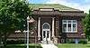 |
(#93001404) |
537 N. Webster 40°05′26″N 98°31′10″W / 40.090556°N 98.519444°W |
Red Cloud | |
| 2 | Matthew R. Bentley House | _from_SE_2.JPG) |
(#82004927) |
845 N. Cedar 40°05′38″N 98°31′14″W / 40.093889°N 98.520556°W |
Red Cloud | |
| 3 | Burlington Depot | 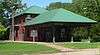 |
(#81000376) |
Seward St. 40°04′38″N 98°31′17″W / 40.077222°N 98.521389°W |
Red Cloud | |
| 4 | Cather House | 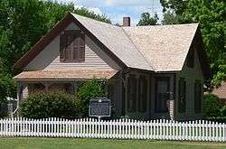 |
(#69000139) |
Southwestern corner of 3rd Avenue and Cedar Street[5] 40°05′14″N 98°31′13″W / 40.087222°N 98.520278°W |
Red Cloud | |
| 5 | George Cather Farmstead |  |
(#82004917) |
Southwest of Bladen: 552 Road T[6] 40°14′57″N 98°38′27″W / 40.249167°N 98.640833°W |
Bladen | |
| 6 | William Cather Homestead Site |  |
(#82004921) |
Northwest of Red Cloud 40°13′07″N 98°39′31″W / 40.218611°N 98.658611°W |
Red Cloud | |
| 7 | Chalk Cliff and Republican River |  |
(#82004919) |
1 mile south of Red Cloud 40°03′43″N 98°31′23″W / 40.061944°N 98.523056°W |
Red Cloud | |
| 8 | City Pharmacy | 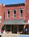 |
(#82004929) |
410 N. Webster 40°05′21″N 98°31′07″W / 40.089167°N 98.518611°W |
Red Cloud | |
| 9 | Crossroads Grave Site | _2.jpg) |
(#82004920) |
Northwest of Red Cloud 40°11′27″N 98°36′48″W / 40.190833°N 98.613333°W |
Red Cloud | |
| 10 | William Ducker House | 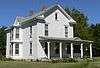 |
(#82004930) |
821 Franklin St. 40°05′37″N 98°31′40″W / 40.093611°N 98.527778°W |
Red Cloud | |
| 11 | Elm St. Historic District |  |
(#82004934) |
Roughly bounded by 10th and 6th Aves. and Locust and Webster Sts. 40°05′35″N 98°31′02″W / 40.093056°N 98.517222°W |
Red Cloud | |
| 12 | Farmer's and Merchant's Bank Building | 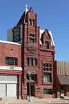 |
(#81000377) |
338 N. Webster St. 40°05′19″N 98°31′07″W / 40.088611°N 98.518611°W |
Red Cloud | |
| 13 | First Baptist Church | 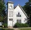 |
(#82003206) |
442 N. Seward St. 40°05′23″N 98°31′17″W / 40.089722°N 98.521389°W |
Red Cloud | |
| 14 | Garber Grove | _from_N_2.JPG) |
(#82004916) |
East of Red Cloud 40°05′06″N 98°30′55″W / 40.085°N 98.515278°W |
Red Cloud | |
| 15 | Grace Protestant Episcopal Church |  |
(#82004931) |
546 N. Cedar St. 40°05′26″N 98°31′12″W / 40.090556°N 98.52°W |
Red Cloud | |
| 16 | IOOF Hall and Opera House |  |
(#88000953) |
Main St. 40°19′21″N 98°35′42″W / 40.3225°N 98.595°W |
Bladen | |
| 17 | Jackson's Reserve | _from_NW_1.JPG) |
(#82004936) |
Bounded by Seward, Cedar, and 3rd Sts. 40°04′51″N 98°31′13″W / 40.080833°N 98.520278°W |
Red Cloud | |
| 18 | Main Street Historic District | 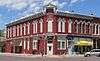 |
(#82004932) |
Roughly bounded by 3rd and 5th Aves. and Elm and Cedar Sts. 40°05′20″N 98°31′09″W / 40.088889°N 98.519167°W |
Red Cloud | |
| 19 | Dr. Gilbert McKeeby House | _from_NE.jpg) |
(#82004937) |
641 N. Cherry St. 40°05′30″N 98°31′34″W / 40.091667°N 98.526111°W |
Red Cloud | |
| 20 | Miner Brothers Store | 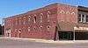 |
(#82004924) |
3rd and Webster Sts. 40°05′17″N 98°31′10″W / 40.088056°N 98.519444°W |
Red Cloud | |
| 21 | Miner House | _from_SE.JPG) |
(#82004922) |
241 N. Seward 40°05′15″N 98°31′19″W / 40.0875°N 98.521944°W |
Red Cloud | |
| 22 | Moon Block | 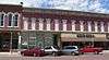 |
(#82004926) |
Webster St. between 4th and 5th Aves. 40°05′22″N 98°31′10″W / 40.089444°N 98.519444°W |
Red Cloud | |
| 23 | Opera House | 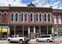 |
(#82004925) |
413 N. Webster 40°05′21″N 98°31′10″W / 40.089167°N 98.519444°W |
Red Cloud | |
| 24 | Pavelka Farmstead |  |
(#79001459) |
Southeast of Bladen 40°16′52″N 98°32′34″W / 40.281111°N 98.542778°W |
Bladen | |
| 25 | Perkins-Wiener House | 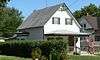 |
(#82004923) |
238 N. Seward 40°05′15″N 98°31′17″W / 40.0875°N 98.521389°W |
Red Cloud | |
| 26 | Pike-Pawnee Village Site |  |
(#66000455) |
Address Restricted |
Guide Rock | |
| 27 | Railroad Addition Historic District | 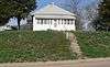 |
(#82004935) |
Roughly bounded by Vine, Division, Seward, Railroad, and 1st Sts. 40°04′46″N 98°31′18″W / 40.079444°N 98.521667°W |
Red Cloud | |
| 28 | Red Cloud Bridge |  |
(#92000726) |
U.S. Route 281 over the Republican River, 2 miles south of Red Cloud 40°03′46″N 98°31′07″W / 40.062778°N 98.518611°W |
Red Cloud | |
| 29 | St. Juliana Falconieri Catholic Church | _from_SE.jpg) |
(#81000378) |
425 W. 3rd St. 40°04′50″N 98°31′24″W / 40.080556°N 98.523333°W |
Red Cloud | |
| 30 | St. Stephenie Scandinavian Evangelical Lutheran Church | 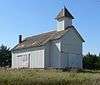 |
(#82004918) |
8 miles northwest of Red Cloud 40°11′25″N 98°35′41″W / 40.190278°N 98.594722°W |
Red Cloud | |
| 31 | Seward Street Historic District | 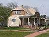 |
(#82004933) |
Roughly bounded by Walnut and Cedar Sts. and 10th and A Aves. 40°05′22″N 98°31′17″W / 40.089444°N 98.521389°W |
Red Cloud | |
| 32 | Starke Round Barn | 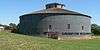 |
(#72000761) |
4.5 miles east of Red Cloud on U.S. Route 136 40°05′21″N 98°26′21″W / 40.089167°N 98.439167°W |
Red Cloud | |
| 33 | US Post Office-Red Cloud | |
(#92000474) |
300 N. Webster 40°05′17″N 98°31′08″W / 40.088055°N 98.518994°W |
Red Cloud | One of 12 Nebraska post offices featuring Section of Fine Arts murals, installed in 1941.[7] |
| 34 | Warner-Cather House |  |
(#82004928) |
541 N. Seward St. 40°05′26″N 98°31′19″W / 40.090556°N 98.521944°W |
Red Cloud | |
| 35 | Webster County Courthouse | 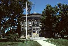 |
(#81000379) |
225 W. 6th St. 40°05′29″N 98°31′16″W / 40.091389°N 98.521111°W |
Red Cloud | |
| 36 | Willa Cather Memorial Prairie |  |
(#82003207) |
South of Red Cloud on U.S. Route 281 40°00′35″N 98°31′41″W / 40.009722°N 98.528056°W |
Red Cloud |
See also
| Wikimedia Commons has media related to National Register of Historic Places in Webster County, Nebraska. |
- List of National Historic Landmarks in Nebraska
- National Register of Historic Places listings in Nebraska
References
- ↑ The latitude and longitude information provided in this table was derived originally from the National Register Information System, which has been found to be fairly accurate for about 99% of listings. For about 1% of NRIS original coordinates, experience has shown that one or both coordinates are typos or otherwise extremely far off; some corrections may have been made. A more subtle problem causes many locations to be off by up to 150 yards, depending on location in the country: most NRIS coordinates were derived from tracing out latitude and longitudes off of USGS topographical quadrant maps created under the North American Datum of 1927, which differs from the current, highly accurate WGS84 GPS system used by most on-line maps. Chicago is about right, but NRIS longitudes in Washington are higher by about 4.5 seconds, and are lower by about 2.0 seconds in Maine. Latitudes differ by about 1.0 second in Florida. Some locations in this table may have been corrected to current GPS standards.
- ↑ "National Register of Historic Places: Weekly List Actions". National Park Service, United States Department of the Interior. Retrieved on December 16, 2016.
- ↑ Numbers represent an ordering by significant words. Various colorings, defined here, differentiate National Historic Landmarks and historic districts from other NRHP buildings, structures, sites or objects.
- ↑ The eight-digit number below each date is the number assigned to each location in the National Register Information System database, which can be viewed by clicking the number.
- ↑ See street sign in photo.
- ↑ See photo of mailbox.
- ↑ Ahlgren, Carol (August 1991). "National Register of Historic Places Multiple Property Documentation Form: Nebraska Post Offices Which Contain Section Artwork (1938-1942)" (PDF). Retrieved 2013-01-28.
| Topics | |
|---|---|
| Lists by states |
|
| Lists by insular areas | |
| Lists by associated states | |
| Other areas | |
| |
Municipalities and communities of Webster County, Nebraska, United States | ||
|---|---|---|
| Cities | ||
| Villages | ||
| CDP | ||
| Unincorporated communities | ||
This article is issued from Wikipedia - version of the 7/28/2016. The text is available under the Creative Commons Attribution/Share Alike but additional terms may apply for the media files.