| [3] |
Name on the Register[4] |
Image |
Date listed[5] |
Location |
City or town |
Description |
|---|
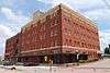
| 1 |
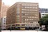
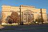
Allen Chapel AME Church |
|
000000001984-10-18-0000October 18, 1984
(#84000169) |
116 Elm St.
32°45′32″N 97°19′38″W / 32.758889°N 97.327222°W / 32.758889; -97.327222 (Allen Chapel AME Church) |
Fort Worth |
|
| 2 |
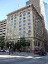
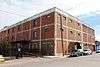
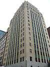
American Airways Hangar and Administration Building |
|
000000002008-04-16-0000April 16, 2008
(#08000317) |
201 Aviation Wy
32°45′03″N 97°19′56″W / 32.750833°N 97.332222°W / 32.750833; -97.332222 (American Airways Hangar and Administration Building) |
Fort Worth |
|
| 3 |
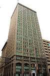
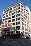
Neil P. Anderson Building |
|
000000001978-03-08-0000March 8, 1978
(#78002981) |
411 W. 7th St.
32°45′03″N 97°19′56″W / 32.750833°N 97.332222°W / 32.750833; -97.332222 (Neil P. Anderson Building) |
Fort Worth |
|
| 4 |
Arlington Post Office |
|
000000002000-03-09-0000March 9, 2000
(#00000188) |
200 W. Main St.
32°44′10″N 97°06′30″W / 32.736111°N 97.108333°W / 32.736111; -97.108333 (Arlington Post Office) |
Arlington |
|
| 5 |
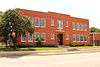
Stephen F. Austin Elementary School |
|
000000001983-03-10-0000March 10, 1983
(#83003160) |
319 Lipscomb St.
32°44′28″N 97°19′57″W / 32.741111°N 97.3325°W / 32.741111; -97.3325 (Stephen F. Austin Elementary School) |
Fort Worth |
|
| 6 |
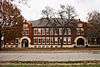
Bedford School |
|
000000001997-08-14-0000August 14, 1997
(#97000851) |
2400 School Ln
32°50′46″N 97°08′26″W / 32.846111°N 97.140556°W / 32.846111; -97.140556 (Bedford School) |
Bedford |
|
| 7 |
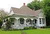
M. A. Benton House |
|
000000001978-05-22-0000May 22, 1978
(#78002982) |
1730 6th Ave.
32°43′31″N 97°20′24″W / 32.725278°N 97.34°W / 32.725278; -97.34 (M. A. Benton House) |
Fort Worth |
|
| 8 |
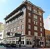
Blackstone Hotel |
|
000000001984-02-02-0000February 2, 1984
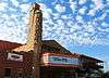
(#84001961) |
601 Main St.
32°45′13″N 97°19′48″W / 32.753611°N 97.33°W / 32.753611; -97.33 (Blackstone Hotel) |
Fort Worth |
|
| 9 |
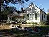
Botts-Fowler House |
|
000000001999-07-01-0000July 1, 1999
(#99000723) |
115 N. Fourth Ave.
32°33′55″N 97°08′45″W / 32.565278°N 97.145833°W / 32.565278; -97.145833 (Botts-Fowler House) |
Mansfield |
|
| 10 |
Andrew "Cap" and Emma Doughty Bratton House |
|
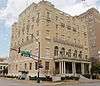
000000002003-05-22-0000May 22, 2003
(#03000432) |
310 E. Broad St.
32°33′46″N 97°08′19″W / 32.562778°N 97.138611°W / 32.562778; -97.138611 (Andrew "Cap" and Emma Doughty Bratton House) |
Mansfield |
part of the Mansfield, Texas Multiple Property Submission (MPS)
|
| 11 |
Bryce Building |
|
000000001984-02-23-0000February 23, 1984
(#84001963) |
909 Throckmorton St.
32°45′04″N 97°19′50″W / 32.7511°N 97.3305°W / 32.7511; -97.3305 (Bryce Building) |
Fort Worth |
|
| 12 |
William J. Bryce House |
|
000000001984-03-01-0000March 1, 1984
(#84001965) |
4900 Bryce Ave.
32°44′23″N 97°23′35″W / 32.739722°N 97.393056°W / 32.739722; -97.393056 (William J. Bryce House) |
Fort Worth |
|
| 13 |
Buchanan-Hayter-Witherspoon House |
|
000000002003-05-22-0000May 22, 2003
(#03000433) |
306 E. Broad St.
32°33′46″N 97°08′19″W / 32.562778°N 97.138611°W / 32.562778; -97.138611 (Buchanan-Hayter-Witherspoon House) |
Mansfield |
part of the Mansfield, Texas MPS
|
| 14 |
Burk Burnett Building |
|
000000001980-11-12-0000November 12, 1980
(#80004151) |
500-502 Main St.
32°45′15″N 97°19′51″W / 32.754167°N 97.330833°W / 32.754167; -97.330833 (Burk Burnett Building) |
Fort Worth |
|
| 15 |
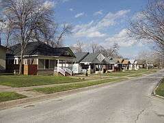
Butler Place Historic District |
|
000000002011-08-04-0000August 4, 2011
(#11000514) |
Roughly bounded by Luella St., I.M. Terrell Way Cir. M., 19th St. & I-35 West,
32°44′59″N 97°19′01″W / 32.749722°N 97.316944°W / 32.749722; -97.316944 (Butler Place Historic District) |
Fort Worth |
|
| 16 |
Central Handley Historic District |
|
000000002002-01-17-0000January 17, 2002
(#01001472) |
Roughly bounded by E. Lancaster Ave., Forest Ave., Kerr St., and Handley Dr.
32°43′58″N 97°13′08″W / 32.732778°N 97.218889°W / 32.732778; -97.218889 (Central Handley Historic District) |
Fort Worth |
|
| 17 |
Lester H. and Mabel Bryant Chorn House |
|
000000002003-05-22-0000May 22, 2003
(#03000434) |
303 E. Broad St.
32°33′48″N 97°08′21″W / 32.563333°N 97.139167°W / 32.563333; -97.139167 (Lester H. and Mabel Bryant Chorn House) |
Mansfield |
part of the Mansfield, Texas MPS
|
| 18 |
Cotton Belt Railroad Industrial Historic District |
|
000000001997-09-04-0000September 4, 1997
(#97001109) |
Along RR tracks, roughly bounded by Hudgins, Dooley, and Dallas Sts.
32°56′00″N 97°04′42″W / 32.933333°N 97.078333°W / 32.933333; -97.078333 (Cotton Belt Railroad Industrial Historic District) |
Grapevine |
part of the Grapevine MPS
|
| 19 |
Eddleman-McFarland House |
|
000000001979-10-18-0000October 18, 1979
(#79003009) |
1110 Penn St.
32°44′50″N 97°20′33″W / 32.747222°N 97.3425°W / 32.747222; -97.3425 (Eddleman-McFarland House) |
Fort Worth |
|
| 20 |
Eighth Avenue Historic District |
|
000000002006-11-21-0000November 21, 2006
(#06001065) |
Bounded by 8th Ave., Pennsylvania Ave., 9th Ave., and Pruitt St.
32°44′24″N 97°20′39″W / 32.74°N 97.344167°W / 32.74; -97.344167 (Eighth Avenue Historic District) |
Fort Worth |
|
| 21 |
Electric Building |
|
000000001995-02-10-0000February 10, 1995
(#95000048) |
410 W. 7th St.
32°45′05″N 97°19′58″W / 32.751389°N 97.332778°W / 32.751389; -97.332778 (Electric Building) |
Fort Worth |
|
| 22 |
Elizabeth Boulevard Historic District |
|
000000001979-11-16-0000November 16, 1979
(#79003010) |
1001-1616 Elizabeth Blvd.
32°42′58″N 97°20′20″W / 32.716111°N 97.338889°W / 32.716111; -97.338889 (Elizabeth Boulevard Historic District) |
Fort Worth |
|
| 23 |
Fairmount-Southside Historic District |
|
000000001990-04-05-0000April 5, 1990
(#90000490) |
Roughly bounded by Magnolia, Hemphill, Eighth, and Jessamine
• Boundary increase (listed 000000001999-05-12-0000May 12, 1999, refnum 99000565): Roughly bounded by Magnolia, Hemphill, Allen, Travis and Morphy St.
32°43′30″N 97°20′15″W / 32.725°N 97.3375°W / 32.725; -97.3375 (Fairmount-Southside Historic District) |
Fort Worth |
|
| 24 |
Farmers and Mechanics National Bank |
|
000000002012-12-04-0000December 4, 2012
(#12001004) |
714 Main St.
32°45′10″N 97°19′49″W / 32.75274°N 97.33029°W / 32.75274; -97.33029 (Farmers and Mechanics National Bank) |
Fort Worth |
Now the main headquarters of XTO Energy
|
| 25 |
First Christian Church |
|
000000001983-10-06-0000October 6, 1983
(#83003812) |
612 Throckorton St.
32°45′09″N 97°19′57″W / 32.7525°N 97.3324°W / 32.7525; -97.3324 (First Christian Church) |
Fort Worth |
|
| 26 |
First National Bank Building |
|
000000002009-12-03-0000December 3, 2009
(#09000981) |
711 Houston St.
32°45′09″N 97°19′50″W / 32.752592°N 97.330572°W / 32.752592; -97.330572 (First National Bank Building) |
Fort Worth |
|
| 27 |
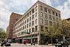
Flatiron Building |
|
000000001971-03-31-0000March 31, 1971
(#71000964) |
1000 Houston St.
32°45′01″N 97°19′46″W / 32.750278°N 97.329444°W / 32.750278; -97.329444 (Flatiron Building) |
Fort Worth |
|
| 28 |
Fort Worth Botanic Garden |
|
000000002009-01-29-0000January 29, 2009
(#08001400) |
3220 Botanic Garden Blvd.
32°44′26″N 97°21′46″W / 32.740475°N 97.362658°W / 32.740475; -97.362658 (Fort Worth Botanic Garden) |
Fort Worth |
|
| 29 |
Fort Worth Club Building-1916 |
|
000000001998-02-12-0000February 12, 1998
(#98000102) |
608-610 Main St.
32°44′41″N 97°19′50″W / 32.744722°N 97.330556°W / 32.744722; -97.330556 (Fort Worth Club Building-1916) |
Fort Worth |
|
| 30 |
Fort Worth Elks Lodge 124 |
|
000000001984-02-16-0000February 16, 1984
(#84001969) |
512 W. 4th St.
32°45′10″N 97°20′05″W / 32.752778°N 97.334722°W / 32.752778; -97.334722 (Fort Worth Elks Lodge 124) |
Fort Worth |
|
| 31 |
Fort Worth High School |
|
000000002002-12-12-0000December 12, 2002
(#02001515) |
1015 S. Jennings Ave.
32°44′08″N 97°19′46″W / 32.735556°N 97.329444°W / 32.735556; -97.329444 (Fort Worth High School) |
Fort Worth |
|
| 32 |
Fort Worth Public Market |
|
000000001984-01-05-0000January 5, 1984
(#84001981) |
1400 Henderson St.
32°44′39″N 97°20′16″W / 32.744167°N 97.337778°W / 32.744167; -97.337778 (Fort Worth Public Market) |
Fort Worth |
|
| 33 |
Fort Worth Recreation Building |
|
000000002014-06-13-0000June 13, 2014
(#14000343) |
215 West Vickery Boulevard
32°44′36″N 97°19′39″W / 32.743418°N 97.327378°W / 32.743418; -97.327378 (Fort Worth Recreation Building) |
Fort Worth |
|
| 34 |
Fort Worth Stockyards Historic District |
|
000000001976-06-29-0000June 29, 1976
(#76002067) |
Roughly bounded by 23rd, Houston, and 28th Sts., and railroad
32°47′25″N 97°20′46″W / 32.790278°N 97.346111°W / 32.790278; -97.346111 (Fort Worth Stockyards Historic District) |
Fort Worth |
|
| 35 |
Fort Worth US Courthouse |
|
000000002001-04-25-0000April 25, 2001
(#01000437) |
501 W. 10th St.
32°44′56″N 97°20′02″W / 32.748889°N 97.333889°W / 32.748889; -97.333889 (Fort Worth US Courthouse) |
Fort Worth |
|
| 36 |
Fort Worth Warehouse and Transfer Company Building |
|
000000002013-03-27-0000March 27, 2013
(#13000126) |
201 S. Calhoun St.
32°44′33″N 97°19′25″W / 32.74240°N 97.32359°W / 32.74240; -97.32359 (Fort Worth Warehouse and Transfer Company Building) |
Fort Worth |
|
| 37 |
Fortune Arms Apartments |
|
000000002016-06-07-0000June 7, 2016
(#16000353) |
601 W. 1st St.
32°45′15″N 97°20′11″W / 32.754278°N 97.336270°W / 32.754278; -97.336270 (Fortune Arms Apartments) |
Fort Worth |
[6]
|
| 38 |
Eldred W. Foster House |
|
000000002012-08-28-0000August 28, 2012
(#12000589) |
9608 Heron Dr.
32°47′44″N 97°29′10″W / 32.795419°N 97.486144°W / 32.795419; -97.486144 (Eldred W. Foster House) |
Fort Worth |
|
| 39 |
Grand Avenue Historic District |
|
000000001990-03-01-0000March 1, 1990
(#90000337) |
Roughly Grand Ave. from Northside to Park
32°46′20″N 97°21′38″W / 32.772222°N 97.360556°W / 32.772222; -97.360556 (Grand Avenue Historic District) |
Fort Worth |
|
| 40 |
Grapevine Commercial Historic District |
|
000000001992-03-09-0000March 9, 1992
(#92000097) |
404-432 S. Main St.
• Boundary increase I (listed 000000001997-05-16-0000May 16, 1997, refnum 97000444): 300 and 400 blocks of S. Main St.
• Boundary increase II (listed 000000002002-12-19-0000December 19, 2002, refnum 02001569): 500-530 S. Main St.
32°56′12″N 97°04′43″W / 32.936667°N 97.078611°W / 32.936667; -97.078611 (Grapevine Commercial Historic District) |
Grapevine |
part of the Grapevine MPS
|
| 41 |
James E. Guinn School |
|
000000001998-05-12-0000May 12, 1998
(#98000429) |
1200 South Freeway
32°43′54″N 97°19′15″W / 32.731667°N 97.320833°W / 32.731667; -97.320833 (James E. Guinn School) |
Fort Worth |
|
| 42 |
Gulf, Colorado and Sante Fe Railroad Passenger Station |
|
000000001970-10-15-0000October 15, 1970
(#70000760) |
1601 Jones St.
32°44′57″N 97°19′26″W / 32.749167°N 97.323889°W / 32.749167; -97.323889 (Gulf, Colorado and Sante Fe Railroad Passenger Station) |
Fort Worth |
|
| 43 |
Henderson Street Bridge |
|
000000002011-03-21-0000March 21, 2011
(#11000128) |
Henderson Street at the Clear Fork of the Trinity River
32°45′29″N 97°20′32″W / 32.757986°N 97.342222°W / 32.757986; -97.342222 (Henderson Street Bridge) |
Fort Worth |
Historic Bridges of Texas MPS
|
| 44 |
Heritage Park Plaza |
|
000000002010-05-10-0000May 10, 2010
(#10000253) |
W Bluff St at Main St
32°45′29″N 97°20′04″W / 32.758056°N 97.334306°W / 32.758056; -97.334306 (Heritage Park Plaza) |
Fort Worth |
|
| 45 |
Alexander Hogg School |
|
000000002002-12-12-0000December 12, 2002
(#02001512) |
900 St. Louis Ave.
32°44′13″N 97°19′43″W / 32.736944°N 97.328611°W / 32.736944; -97.328611 (Alexander Hogg School) |
Fort Worth |
|
| 46 |
Hotel Texas |
|
000000001979-07-03-0000July 3, 1979
(#79003011) |
815 Main and 815 Commerece Streets
32°45′09″N 97°19′45″W / 32.7525°N 97.329167°W / 32.7525; -97.329167 (Hotel Texas) |
Fort Worth |
Boundary increase approved November 2014 to include the annex built across the street at 815 Commerce.[7]
|
| 47 |
Hutcheson-Smith House |
|
000000001984-08-02-0000August 2, 1984
(#84001993) |
312 N. Oak St.
32°44′24″N 97°06′33″W / 32.74°N 97.109167°W / 32.74; -97.109167 (Hutcheson-Smith House) |
Arlington |
|
| 48 |
Inspiration Point Shelter House |
|
000000002014-03-31-0000March 31, 2014
(#14000105) |
Roughly 250 yds. S. of 2400 blk. of Roberts Cut Off Rd.
32°47′41″N 97°24′36″W / 32.794717°N 97.409917°W / 32.794717; -97.409917 (Inspiration Point Shelter House) |
Fort Worth |
|
| 49 |
Johnson-Elliott House |
|
000000001984-05-10-0000May 10, 1984
(#84001996) |
3 Chase Ct.
32°43′31″N 97°19′54″W / 32.725278°N 97.331667°W / 32.725278; -97.331667 (Johnson-Elliott House) |
Fort Worth |
|
| 50 |
Knights of Pythias Building |
|
000000001970-04-28-0000April 28, 1970
(#70000761) |
315 Main St.
32°45′19″N 97°19′52″W / 32.755278°N 97.331111°W / 32.755278; -97.331111 (Knights of Pythias Building) |
Fort Worth |
|
| 51 |
Kress Building |
|
000000002007-04-04-0000April 4, 2007
(#07000266) |
604 Main St.
32°45′12″N 97°19′52″W / 32.753333°N 97.331111°W / 32.753333; -97.331111 (Kress Building) |
Fort Worth |
|
| 52 |
Leuda-May Historic District |
|
000000002005-03-30-0000March 30, 2005
(#05000240) |
301-311 W. Leuda and 805-807 May Sts.
32°44′14″N 97°19′44″W / 32.737222°N 97.328889°W / 32.737222; -97.328889 (Leuda-May Historic District) |
Fort Worth |
|
| 53 |
Ralph Sandiford and Julia Boisseau Man House |
|
000000002003-05-22-0000May 22, 2003
(#03000435) |
604 W. Broad St.
32°33′55″N 97°08′57″W / 32.565297°N 97.149072°W / 32.565297; -97.149072 (Ralph Sandiford and Julia Boisseau Man House) |
Mansfield |
part of the Mansfield, Texas MPS
|
| 54 |
Marine Commercial Historic District |
|
000000002001-02-09-0000February 9, 2001
(#01000102) |
Roughly defined by N. Main St., bet. N. Side Dr. and N. 14th St.
32°46′39″N 97°20′46″W / 32.7775°N 97.346111°W / 32.7775; -97.346111 (Marine Commercial Historic District) |
Fort Worth |
|
| 55 |
Markeen Apartments |
|
000000002001-05-02-0000May 2, 2001
(#01000470) |
210-14 St. Louis Ave. and 406-10 W. Daggett Ave.
32°44′31″N 97°19′41″W / 32.741944°N 97.328056°W / 32.741944; -97.328056 (Markeen Apartments) |
Fort Worth |
|
| 56 |
Marrow Bone Spring Archeological Site |
|
000000001978-11-21-0000November 21, 1978
(#78002980) |
Vandergriff Park
Address Restricted
|
Arlington |
|
| 57 |
Masonic Widows and Orphans Home Historic District |
|
000000001992-01-28-0000January 28, 1992
(#91002022) |
Roughly bounded by E. Berry St., Mitchell Blvd., Vaughn St., Wichita St. and Glen Garden Dr
32°42′33″N 97°17′00″W / 32.709167°N 97.283333°W / 32.709167; -97.283333 (Masonic Widows and Orphans Home Historic District) |
Fort Worth |
|
| 58 |
Miller Manufacturing Company Building |
|
000000002010-10-28-0000October 28, 2010
(#10000865) |
311 Bryan Ave.
32°44′28″N 97°19′29″W / 32.741111°N 97.324722°W / 32.741111; -97.324722 (Miller Manufacturing Company Building) |
Fort Worth |
|
| 59 |
Montgomery Ward and Company Building |
|
000000001998-11-19-0000November 19, 1998
(#98001415) |
801 Grove St.
32°45′14″N 97°19′34″W / 32.753889°N 97.326111°W / 32.753889; -97.326111 (Montgomery Ward and Company Building) |
Fort Worth |
|
| 60 |
Morning Chapel Colored Methodist Episcopal Church |
|
000000001999-08-27-0000August 27, 1999
(#99001049) |
901 E. Third St.
32°45′30″N 97°19′30″W / 32.758333°N 97.325°W / 32.758333; -97.325 (Morning Chapel Colored Methodist Episcopal Church) |
Fort Worth |
|
| 61 |
Thomas J. and Elizabeth Nash Farm |
|
000000002010-10-28-0000October 28, 2010
(#10000866) |
626 Ball St.
32°56′03″N 97°05′09″W / 32.934167°N 97.085833°W / 32.934167; -97.085833 (Thomas J. and Elizabeth Nash Farm) |
Grapevine |
|
| 62 |
Near Southeast Historic District |
|
000000002002-04-26-0000April 26, 2002
(#02000405) |
Roughly bounded by New York Ave., E. Terrell Ave., former I&GN Railway, Verbena St., and N side of E. Terrell Ave,
32°43′58″N 97°14′15″W / 32.732778°N 97.2375°W / 32.732778; -97.2375 (Near Southeast Historic District) |
Fort Worth |
|
| 63 |
North Fort Worth High School |
|
000000001995-02-02-0000February 2, 1995
(#94001627) |
600 Park St.
32°46′52″N 97°21′24″W / 32.781111°N 97.356667°W / 32.781111; -97.356667 (North Fort Worth High School) |
Fort Worth |
|
| 64 |
Oakhurst Historic District |
|
000000002010-02-24-0000February 24, 2010
(#10000051) |
Roughly bounded by Yucca Ave., Sylvania Ave., Watauga Ave., and Oakhurst Scenic Dr.
32°47′08″N 97°18′48″W / 32.785556°N 97.313333°W / 32.785556; -97.313333 (Oakhurst Historic District) |
Fort Worth |
part of the Historic Residential Suburbs in the United States, 1830-1960 MPS
|
| 65 |
Old Town Historic District |
|
000000002000-03-23-0000March 23, 2000
(#00000247) |
Roughly bounded by Sanford, Elm, North, Prairie and Oak Sts.
32°44′27″N 97°06′05″W / 32.740833°N 97.101389°W / 32.740833; -97.101389 (Old Town Historic District) |
Arlington |
part of the Arlington Multiple Resource Area (MRA)
|
| 66 |
Original Town Residential Historic District |
|
000000001998-07-10-0000July 10, 1998
(#98000736) |
Roughly bounded by Texas, Austin, Hudgins and Jenkins Sts.
32°56′11″N 97°04′28″W / 32.936389°N 97.074444°W / 32.936389; -97.074444 (Original Town Residential Historic District) |
Grapevine |
part of the Grapevine MPS
|
| 67 |
Our Lady of Victory Academy |
|
000000002004-08-20-0000August 20, 2004
(#04000886) |
801 W. Shaw St.
32°42′11″N 97°19′59″W / 32.703056°N 97.333056°W / 32.703056; -97.333056 (Our Lady of Victory Academy) |
Fort Worth |
|
| 68 |
Our Mother of Mercy Catholic Church and Parsonage |
|
000000001999-07-22-0000July 22, 1999
(#99000882) |
1100 and 1104 Evans Ave.
32°43′57″N 97°19′05″W / 32.7325°N 97.318056°W / 32.7325; -97.318056 (Our Mother of Mercy Catholic Church and Parsonage) |
Fort Worth |
|
| 69 |
Our Mother of Mercy School |
|
000000002006-06-15-0000June 15, 2006
(#06000510) |
801 Verbena St.
32°44′06″N 97°19′08″W / 32.735°N 97.318889°W / 32.735; -97.318889 (Our Mother of Mercy School) |
Fort Worth |
|
| 70 |
Paddock Viaduct |
|
000000001976-03-15-0000March 15, 1976
(#76002068) |
Main St.
32°45′36″N 97°20′05″W / 32.76°N 97.334722°W / 32.76; -97.334722 (Paddock Viaduct) |
Fort Worth |
|
| 71 |
Parker-Browne Company Building |
|
000000002015-06-03-0000June 3, 2015
(#15000337) |
1212 E. Lancaster Ave.
32°44′45″N 97°19′00″W / 32.745891°N 97.316580°W / 32.745891; -97.316580 (Parker-Browne Company Building) |
Fort Worth |
|
| 72 |
Petroleum Building |
|
000000002009-12-03-0000December 3, 2009
(#09000982) |
210 W. 6th St.
32°45′10″N 97°19′54″W / 32.752828°N 97.331786°W / 32.752828; -97.331786 (Petroleum Building) |
Fort Worth |
|
| 73 |
Pollock-Capps House |
|
000000001972-06-19-0000June 19, 1972
(#72001372) |
1120 Penn St.
32°44′49″N 97°20′33″W / 32.746944°N 97.3425°W / 32.746944; -97.3425 (Pollock-Capps House) |
Fort Worth |
|
| 74 |
Dr. Arvel and Faye Ponton House |
|
000000002006-11-29-0000November 29, 2006
(#06001085) |
1208 Mistletoe Dr.
32°43′50″N 97°21′22″W / 32.730556°N 97.356111°W / 32.730556; -97.356111 (Dr. Arvel and Faye Ponton House) |
Fort Worth |
|
| 75 |
Ridglea Theatre |
|
000000002011-12-30-0000December 30, 2011
(#11000982) |
6025-6033 Camp Bowie Rd. & 3309 Winthrop Ave.
32°43′44″N 97°24′52″W / 32.72885°N 97.41453°W / 32.72885; -97.41453 (Ridglea Theatre) |
Fort Worth |
|
| 76 |
Riverside Public School |
|
000000001999-12-30-0000December 30, 1999
(#99001624) |
2629 LaSalle St.
32°45′29″N 97°18′19″W / 32.758056°N 97.305278°W / 32.758056; -97.305278 (Riverside Public School) |
Fort Worth |
|
| 77 |
Will Rogers Memorial Center |
|
000000002016-03-22-0000March 22, 2016
(#16000122) |
3401 W. Lancaster Ave.
32°44′46″N 97°21′59″W / 32.746158°N 97.366315°W / 32.746158; -97.366315 (Will Rogers Memorial Center) |
Fort Worth |
|
| 78 |
Rogers-O'Daniel House |
|
000000001985-07-05-0000July 5, 1985
(#85001484) |
2230 Warner Rd.
32°42′35″N 97°20′50″W / 32.709722°N 97.347222°W / 32.709722; -97.347222 (Rogers-O'Daniel House) |
Fort Worth |
|
| 79 |
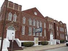
Saint James Second Street Baptist Church |
|
000000001999-07-22-0000July 22, 1999
(#99000883) |
210 Harding St.
32°45′34″N 97°19′28″W / 32.759444°N 97.324444°W / 32.759444; -97.324444 (Saint James Second Street Baptist Church) |
Fort Worth |
|
| 80 |
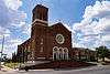
St. Mary of the Assumption Church |
|
000000001984-05-10-0000May 10, 1984
(#84001998) |
501 W. Magnolia Ave.
32°43′49″N 97°19′48″W / 32.730278°N 97.33°W / 32.730278; -97.33 (St. Mary of the Assumption Church) |
Fort Worth |
|
| 81 |
St. Patrick Cathedral Complex |
|
000000001985-01-07-0000January 7, 1985
(#85000074) |
1206 Throckmorton
32°44′56″N 97°19′46″W / 32.748889°N 97.329444°W / 32.748889; -97.329444 (St. Patrick Cathedral Complex) |
Fort Worth |
|
| 82 |
Sanger Brothers Building |
|
000000001994-06-03-0000June 3, 1994
(#94000542) |
410-412 Houston St.
32°45′15″N 97°19′55″W / 32.754167°N 97.331944°W / 32.754167; -97.331944 (Sanger Brothers Building) |
Fort Worth |
|
| 83 |
Sanger Brothers Building |
|
000000002014-12-10-0000December 10, 2014
(#14001035) |
515 Houston St.
32°45′13″N 97°19′53″W / 32.753708°N 97.331446°W / 32.753708; -97.331446 (Sanger Brothers Building) |
Fort Worth |
|
| 84 |
Marshall R. Sanguinet House |
|
000000001983-06-07-0000June 7, 1983
(#83003162) |
4729 Collinwood Ave.
32°44′14″N 97°23′26″W / 32.737222°N 97.390556°W / 32.737222; -97.390556 (Marshall R. Sanguinet House) |
Fort Worth |
|
| 85 |
J.L. Sealy Building |
|
000000002013-08-20-0000August 20, 2013
(#13000612) |
801 S. Main St.
32°44′11″N 97°19′32″W / 32.73643°N 97.32568°W / 32.73643; -97.32568 (J.L. Sealy Building) |
Fort Worth |
|
| 86 |
Thomas and Marjorie Shaw House |
|
000000001995-08-22-0000August 22, 1995
(#95001029) |
2404 Medford Ct. E.
32°43′03″N 97°21′24″W / 32.7175°N 97.356667°W / 32.7175; -97.356667 (Thomas and Marjorie Shaw House) |
Fort Worth |
|
| 87 |
Sinclair Building |
|
000000001992-01-07-0000January 7, 1992
(#91001913) |
512 Main St.
32°45′14″N 97°19′51″W / 32.753889°N 97.330833°W / 32.753889; -97.330833 (Sinclair Building) |
Fort Worth |
|
| 88 |
South Center Street Historic District |
|
000000002003-05-01-0000May 1, 2003
(#03000334) |
500-600 blks of S. Center St.
32°43′53″N 97°06′24″W / 32.731389°N 97.106667°W / 32.731389; -97.106667 (South Center Street Historic District) |
Arlington |
|
| 89 |
South Main St. Historic District |
|
000000002009-12-03-0000December 3, 2009
(#09000984) |
104, 108, 126, & 200 blocks of S. Main St.
32°44′33″N 97°19′33″W / 32.7425°N 97.325903°W / 32.7425; -97.325903 (South Main St. Historic District) |
Fort Worth |
|
| 90 |
South Side Masonic Lodge No. 1114 |
|
000000001985-01-03-0000January 3, 1985
(#85000048) |
1301 W. Magnolia
32°43′48″N 97°20′16″W / 32.73°N 97.337778°W / 32.73; -97.337778 (South Side Masonic Lodge No. 1114) |
Fort Worth |
|
| 91 |
Tabernacle Baptist Church |
|
000000001999-11-30-0000November 30, 1999
(#99001451) |
1801 Evans Ave.
32°43′29″N 97°19′03″W / 32.724722°N 97.3175°W / 32.724722; -97.3175 (Tabernacle Baptist Church) |
Fort Worth |
|
| 92 |
Tarrant County Courthouse |
|
000000001970-10-15-0000October 15, 1970
(#70000762) |
Bounded by Houston, Belknap, Weatherford, and Commerce Sts.
32°45′26″N 97°19′58″W / 32.757222°N 97.332778°W / 32.757222; -97.332778 (Tarrant County Courthouse) |
Fort Worth |
|
| 93 |
Texas and Pacific Terminal Complex |
|
000000001978-05-26-0000May 26, 1978
(#78002983) |
Lancaster and Throckmorton Sts.
32°44′45″N 97°19′43″W / 32.745833°N 97.328611°W / 32.745833; -97.328611 (Texas and Pacific Terminal Complex) |
Fort Worth |
|
| 94 |
Texas Garden Clubs, Inc., Headquarters |
|
000000002011-03-21-0000March 21, 2011
(#11000136) |
3111 Old Garden Rd.
32°44′09″N 97°21′52″W / 32.735764°N 97.364583°W / 32.735764; -97.364583 (Texas Garden Clubs, Inc., Headquarters) |
Fort Worth |
|
| 95 |
US Post Office |
|
000000001985-04-15-0000April 15, 1985
(#85000855) |
251 W. Lancaster Ave.[8]
32°44′47″N 97°19′46″W / 32.7464°N 97.3294°W / 32.7464; -97.3294 (US Post Office) |
Fort Worth |
|
| 96 |
Van Zandt Cottage |
|
000000002012-12-04-0000December 4, 2012
(#12001005) |
2900 Crestline Rd.
32°44′39″N 97°21′32″W / 32.74406°N 97.35879°W / 32.74406; -97.35879 (Van Zandt Cottage) |
Fort Worth |
|
| 97 |
Vandergriff Building |
|
000000002010-07-26-0000July 26, 2010
(#10000500) |
100 E Division St.
32°44′20″N 97°06′24″W / 32.738819°N 97.106528°W / 32.738819; -97.106528 (Vandergriff Building) |
Arlington |
|
| 98 |
Vaught House |
|
000000002005-08-10-0000August 10, 2005
(#05000864) |
718 W. Abram St.
32°44′06″N 97°06′56″W / 32.735°N 97.115556°W / 32.735; -97.115556 (Vaught House) |
Arlington |
|
| 99 |
W. T. Waggoner Building |
|
000000001979-07-10-0000July 10, 1979
(#79003012) |
810 Houston St.
32°45′05″N 97°19′49″W / 32.751389°N 97.330278°W / 32.751389; -97.330278 (W. T. Waggoner Building) |
Fort Worth |
|
| 100 |
Wallace-Hall House |
|
000000002003-05-22-0000May 22, 2003
(#03000436) |
210 S. Main St.
32°33′42″N 97°08′32″W / 32.561667°N 97.142222°W / 32.561667; -97.142222 (Wallace-Hall House) |
Mansfield |
part of the Mansfield, Texas MPS
|
| 101 |
Roy A. and Gladys Westbrook House |
|
000000002009-01-08-0000January 8, 2009
(#08001300) |
2232 Winton Terrace W.
32°43′15″N 97°21′35″W / 32.720792°N 97.359631°W / 32.720792; -97.359631 (Roy A. and Gladys Westbrook House) |
Fort Worth |
|
| 102 |
Westover Manor |
|
000000001988-12-15-0000December 15, 1988
(#88002709) |
8 Westover Rd.
32°44′31″N 97°24′14″W / 32.741944°N 97.403889°W / 32.741944; -97.403889 (Westover Manor) |
Westover Hills |
|
| 103 |
Wharton-Scott House |
|
000000001975-04-14-0000April 14, 1975
(#75002003) |
1509 Pennsylvania Ave.
32°44′16″N 97°20′32″W / 32.737778°N 97.342222°W / 32.737778; -97.342222 (Wharton-Scott House) |
Fort Worth |
|
| 104 |
F. W. Woolworth Building |
|
000000001994-11-25-0000November 25, 1994
(#94001359) |
501 Houston St.
32°45′12″N 97°19′52″W / 32.753333°N 97.331111°W / 32.753333; -97.331111 (F. W. Woolworth Building) |
Fort Worth |
|


.jpg)
.jpg)
.jpg)

.jpg)
.jpg)

.jpg)

.jpg)

.jpg)


.jpg)


.jpg)

.jpg)

.jpg)

.jpg)


.jpg)


.jpg)


.jpg)


.jpg)


.jpg)
.jpg)

.jpg)

.jpg)


.jpg)
.jpg)
.jpg)
.jpg)
