National Register of Historic Places listings in St. Charles County, Missouri
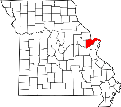
Location of St. Charles County in Missouri
This is a list of the National Register of Historic Places listings in St. Charles County, Missouri.
This is intended to be a complete list of the properties and districts on the National Register of Historic Places in St. Charles County, Missouri, United States. Latitude and longitude coordinates are provided for many National Register properties and districts; these locations may be seen together in a map.[1]
There are 33 properties and districts listed on the National Register in the county. Another property was once listed but has been removed.
- This National Park Service list is complete through NPS recent listings posted December 16, 2016.[2]
Current listings
| [3] | Name on the Register | Image | Date listed[4] | Location | City or town | Description |
|---|---|---|---|---|---|---|
| 1 | African Church | Upload image | (#80004366) |
554 Madison St. 38°46′57″N 90°29′17″W / 38.7825°N 90.488056°W |
St. Charles | |
| 2 | Augusta Harmonie Verein |  |
(#94001554) |
Junction of Hackman and Church Rds. 38°34′32″N 90°52′44″W / 38.575556°N 90.878889°W |
Augusta | |
| 3 | Daniel Boone Home |  |
(#73002175) |
Hwy. F 38°39′06″N 90°51′14″W / 38.651667°N 90.853889°W |
Defiance | |
| 4 | Robert Ewich Farmstead | Upload image | (#94001556) |
5336 Hackman Rd. 38°34′30″N 90°52′40″W / 38.575°N 90.877778°W |
Augusta | |
| 5 | Charles McLee Farris House | 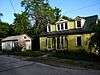 |
(#94001559) |
5517 High St. 38°34′18″N 90°52′58″W / 38.571667°N 90.882778°W |
Augusta | |
| 6 | First Missouri State Capitol Buildings | 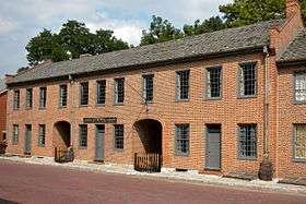 |
(#69000313) |
208-216 S. Main St. 38°46′47″N 90°28′53″W / 38.779722°N 90.481389°W |
St. Charles | |
| 7 | Frenchtown Historic District | Upload image | (#91000216) |
Roughly bounded by N. Fifth, Clark and French Sts. and the Missouri R. 38°47′19″N 90°28′48″W / 38.788611°N 90.48°W |
St. Charles | |
| 8 | Dr. C. L. Gerling House |  |
(#94001558) |
245 Lower St. 38°34′22″N 90°52′56″W / 38.572778°N 90.882222°W |
Augusta | |
| 9 | Harold-Knoernschild Farmstead Historic District | Upload image | (#94001145) |
199 Jackson St. 38°34′25″N 90°53′04″W / 38.573611°N 90.884444°W |
Augusta | |
| 10 | Daniel Boone Hays House | Upload image | (#73002176) |
SW of Defiance off Hwy. F 38°37′18″N 90°49′19″W / 38.621667°N 90.821944°W |
Defiance | |
| 11 | Lindenwood Hall |  |
(#78003131) |
Lindenwood Colleges campus 38°47′14″N 90°29′58″W / 38.787222°N 90.499444°W |
St. Charles | |
| 12 | Lindenwood Neighborhood Historic District | Upload image | (#16000728) |
Roughly bounded by Watson, Gamble, Sibley & Elm Sts. & alley between Houston & N. Kingshighway 38°47′18″N 90°29′45″W / 38.788303°N 90.495854°W |
St. Charles | |
| 13 | Oliver L. and Catherine Link House | Upload image | (#13000584) |
1005 Jefferson 38°47′05″N 90°29′35″W / 38.784774°N 90.493085°W |
St. Charles | |
| 14 | Marten-Becker House | Upload image | (#79003200) |
837 First Capitol Dr. 38°46′55″N 90°29′27″W / 38.781944°N 90.490833°W |
St. Charles | |
| 15 | Isaac McCormick House | Upload image | (#04000960) |
705 MO F 38°38′28″N 90°48′18″W / 38.641111°N 90.805°W |
Defiance | |
| 16 | Meier General Store | Upload image | (#02000794) |
3669 Mill St. 38°42′43″N 90°52′47″W / 38.711944°N 90.879722°W |
New Melle | |
| 17 | Mindrup House-Store | 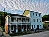 |
(#94001557) |
5543 Water St. 38°34′13″N 90°53′01″W / 38.570278°N 90.883611°W |
Augusta | |
| 18 | Midtown Neighborhood Historic District | Upload image | (#14000885) |
Roughly bounded by Clark, Madison, Jefferson, Kingshighway, 2nd & 3rd Sts. 38°47′00″N 90°29′00″W / 38.7833°N 90.4833°W |
St. Charles | |
| 19 | Mt. Pleasant Winery Historic District | Upload image | (#94001144) |
5634 High St. 38°34′13″N 90°52′30″W / 38.570278°N 90.875°W |
Augusta | |
| 20 | Newbill-McElhiney House | 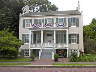 |
(#72001489) |
625 S. Main St. 38°46′35″N 90°29′02″W / 38.776389°N 90.483889°W |
St. Charles | |
| 21 | Old City Hall | 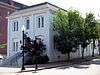 |
(#80004367) |
Central Ave. and Main St. 38°46′51″N 90°28′54″W / 38.780833°N 90.481667°W |
St. Charles | |
| 22 | St. Charles Historic District | 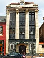 |
(#70000856) |
Roughly, Main St. from Adams St. on the north to Boone's Lick Rd. on the south, east to the Missouri river, west to 2nd St. 38°46′33″N 90°28′41″W / 38.775833°N 90.478056°W |
St. Charles | A historic district with over 100 contributing buildings. Originally listed on September 22, 1970 with increases on June 4, 1987, May 1, 1991 and October 10, 1996 |
| 23 | St. Charles Odd Fellows Hall |  |
(#87000569) |
117 S. Main 38°46′50″N 90°28′54″W / 38.780556°N 90.481667°W |
St. Charles | |
| 24 | St. Mary's Institute of O'Fallon | Upload image | (#07001106) |
204 N. Main St. Coordinates missing |
O'Fallon | |
| 25 | St. Paul's Church | Upload image | (#82004713) |
SR D 38°42′31″N 90°52′56″W / 38.708611°N 90.882222°W |
New Melle | |
| 26 | J. F. Schroer House-Store | Upload image | (#94001555) |
252 Lower St. 38°34′21″N 90°52′53″W / 38.5725°N 90.881389°W |
Augusta | |
| 27 | August Sehrt House | 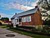 |
(#94001143) |
275 Webster St. 38°34′17″N 90°53′09″W / 38.571389°N 90.885833°W |
Augusta | |
| 28 | Staudinger-Grumke House-Store | 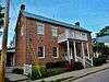 |
(#92000504) |
5503 Locust St. 38°34′27″N 90°52′47″W / 38.574167°N 90.879722°W |
Augusta | |
| 29 | Stone Row | 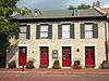 |
(#69000314) |
314-330 S. Main St. 38°46′45″N 90°28′56″W / 38.779167°N 90.482222°W |
St. Charles | |
| 30 | Dr. John H. Stumberg House | Upload image | (#78003132) |
100 S. 3rd St. 38°46′53″N 90°29′00″W / 38.781389°N 90.483333°W |
St. Charles | |
| 31 | Walnut Street Historic District | 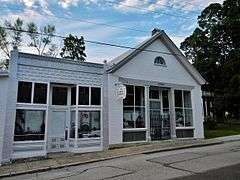 |
(#94001142) |
Walnut and S side of Locust Sts. between Jackson and Lower Sts. 38°34′26″N 90°52′53″W / 38.573889°N 90.881389°W |
Augusta | |
| 32 | Samuel Stewart Watson House | Upload image | (#82004714) |
205 S. Duchesne Dr. 38°47′39″N 90°30′16″W / 38.794167°N 90.504444°W |
St. Charles | |
| 33 | Wentzville Tobacco Company Factory | 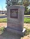 |
(#90001024) |
406 Elm St. 38°48′37″N 90°51′05″W / 38.810278°N 90.851389°W |
Wentzville |
Former listing
| [3] | Name on the Register | Image | Date listed | Date removed | Location | City or town | Summary |
|---|---|---|---|---|---|---|---|
| 1 | Wolf-Ruebeling House | Upload image | (#83001038) | MO 94 |
Defiance | Destroyed in a 1985 fire.[5] |
See also
- List of National Historic Landmarks in Missouri
- National Register of Historic Places listings in Missouri
References
| Wikimedia Commons has media related to National Register of Historic Places in St. Charles County, Missouri. |
- ↑ The latitude and longitude information provided in this table was derived originally from the National Register Information System, which has been found to be fairly accurate for about 99% of listings. For about 1% of NRIS original coordinates, experience has shown that one or both coordinates are typos or otherwise extremely far off; some corrections may have been made. A more subtle problem causes many locations to be off by up to 150 yards, depending on location in the country: most NRIS coordinates were derived from tracing out latitude and longitudes off of USGS topographical quadrant maps created under the North American Datum of 1927, which differs from the current, highly accurate WGS84 GPS system used by most on-line maps. Chicago is about right, but NRIS longitudes in Washington are higher by about 4.5 seconds, and are lower by about 2.0 seconds in Maine. Latitudes differ by about 1.0 second in Florida. Some locations in this table may have been corrected to current GPS standards.
- ↑ "National Register of Historic Places: Weekly List Actions". National Park Service, United States Department of the Interior. Retrieved on December 16, 2016.
- 1 2 Numbers represent an ordering by significant words. Various colorings, defined here, differentiate National Historic Landmarks and historic districts from other NRHP buildings, structures, sites or objects.
- ↑ The eight-digit number below each date is the number assigned to each location in the National Register Information System database, which can be viewed by clicking the number.
- ↑ http://www.dnr.mo.gov/shpo/StCharles.htm
| Topics | |
|---|---|
| Lists by states |
|
| Lists by insular areas | |
| Lists by associated states | |
| Other areas | |
| |
Municipalities and communities of St. Charles County, Missouri, United States | ||
|---|---|---|
| Cities | | |
| Villages | ||
| Townships |
| |
| CDP | ||
| Other unincorporated communities |
| |
| Ghost towns |
| |
| Footnotes | ‡This populated place also has portions in an adjacent county or counties | |
This article is issued from Wikipedia - version of the 11/1/2016. The text is available under the Creative Commons Attribution/Share Alike but additional terms may apply for the media files.