National Register of Historic Places listings in Shoshone County, Idaho

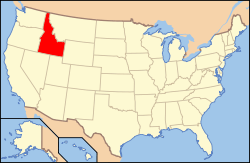
Location of Shoshone County in Idaho
This is a list of the National Register of Historic Places listings in Shoshone County, Idaho.
This is intended to be a complete list of the properties and districts on the National Register of Historic Places in Shoshone County, Idaho, United States. Latitude and longitude coordinates are provided for many National Register properties and districts; these locations may be seen together in a map.[1]
There are 22 properties and districts listed on the National Register in the county. More may be added; properties and districts nationwide are added to the Register weekly.[2]
- This National Park Service list is complete through NPS recent listings posted December 16, 2016.[3]
Current listings
| [4] | Name on the Register[5] | Image | Date listed[6] | Location | City or town | Description |
|---|---|---|---|---|---|---|
| 1 | Avery Depot | 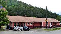 |
(#84001142) |
St. Joe River Rd. 47°15′03″N 115°48′26″W / 47.250797°N 115.807348°W |
Avery | North Idaho 1910 Fire Sites TR |
| 2 | Avery Ranger Station | 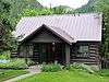 |
(#74000748) |
Near the St. Joe National Forest 47°15′04″N 115°48′20″W / 47.251063°N 115.805636°W |
Avery | |
| 3 | Bullion Tunnel | Upload image | (#84001160) |
East of Avery 47°24′04″N 115°42′04″W / 47.401111°N 115.701111°W |
Avery vicinity | North Idaho 1910 Fire Sites TR |
| 4 | Cedar Snags |  |
(#84001174) |
North of Avery 47°22′30″N 115°45′42″W / 47.374888°N 115.761651°W |
Avery vicinity | North Idaho 1910 Fire Sites TR |
| 5 | Chicago, Milwaukee, St. Paul and Pacific Railroad Company Historic District |  |
(#00001269) |
Idaho Panhandle National Forest (Extends into Mineral County, Montana) 47°21′37″N 115°38′43″W / 47.360167°N 115.645222°W |
Avery vicinity | |
| 6 | John C. Feehan House | Upload image | (#80001334) |
Main St. 47°37′36″N 115°51′05″W / 47.626667°N 115.851389°W |
Murray | |
| 7 | Grand Forks | Upload image | (#84001175) |
East of Avery 47°21′12″N 115°40′25″W / 47.353227°N 115.673701°W |
Avery vicinity | North Idaho 1910 Fire Sites TR |
| 8 | Halm Creek, Bean Creek Fire | Upload image | (#84001177) |
South of Red Ives 47°00′27″N 115°21′13″W / 47.0075°N 115.353611°W |
Red Ives vicinity | North Idaho 1910 Fire Sites TR |
| 9 | Magee Ranger Station | Upload image | (#81000208) |
West of Pritchard 47°50′39″N 116°15′09″W / 47.844054°N 116.252468°W |
Pritchard vicinity | |
| 10 | Mallard Peak Lookout | Upload image | (#84001178) |
Southeast of Avery 46°56′17″N 115°31′30″W / 46.938093°N 115.524903°W |
Avery vicinity | |
| 11 | Murray Courthouse |  |
(#78001098) |
Main St. 47°37′36″N 115°51′15″W / 47.626578°N 115.854172°W |
Murray | Collapsed due to snow load in 1997; subsequently rebuilt in replica.[7] |
| 12 | Murray Masonic Hall | Upload image | (#87000774) |
Main St. between 2nd and 3rd 47°37′37″N 115°51′29″W / 47.626832°N 115.858062°W |
Murray | |
| 13 | Northern Pacific Railway Depot | 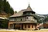 |
(#76000681) |
219 6th St. 47°28′24″N 115°55′25″W / 47.473247°N 115.923603°W |
Wallace | |
| 14 | Pine Creek Baptist Church | 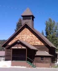 |
(#82000361) |
Main and S. 3rd Sts. 47°32′19″N 116°14′13″W / 47.538698°N 116.236849°W |
Pinehurst | |
| 15 | Edward Pulaski Tunnel and Placer Creek Escape Route | 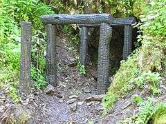 |
(#84001179) |
Southwest of Wallace 47°26′58″N 115°57′24″W / 47.449444°N 115.956667°W |
Wallace vicinity | North Idaho 1910 Fire Sites TR |
| 16 | Red Ives Ranger Station | Upload image | (#86002151) |
Southeast of Avery on Forest Service Rd. 218 47°03′22″N 115°21′08″W / 47.056145°N 115.352316°W |
Avery | |
| 17 | St. Andrew's Episcopal Church | 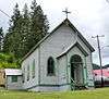 |
(#99000419) |
104 Hunter St. 47°28′12″N 115°48′11″W / 47.470095°N 115.802944°W |
Mullan | |
| 18 | U.S. Post Office – Kellogg Main | 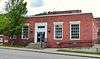 |
(#89002118) |
302 S. Division St. 47°32′04″N 116°07′18″W / 47.534526°N 116.121742°W |
Kellogg | |
| 19 | U.S. Post Office – Wallace Main | |
(#89000137) |
403 Cedar St. 47°28′21″N 115°55′36″W / 47.472617°N 115.926711°W |
Wallace | |
| 20 | Wallace 1910 Fire Memorial |  |
(#84001180) |
North of Wallace 47°29′16″N 115°54′56″W / 47.487704°N 115.915564°W |
Wallace | North Idaho 1910 Fire Sites TR |
| 21 | Wallace Carnegie Library | 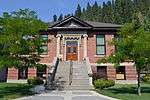 |
(#81000209) |
415 River St. 47°28′27″N 115°55′34″W / 47.474189°N 115.926149°W |
Wallace | |
| 22 | Wallace Historic District |  |
(#79000809) |
Roughly bounded by Oak, Silver, C, Mullan, Canyon, Fir, and 1st Sts. 47°28′20″N 115°55′34″W / 47.4723°N 115.9262°W |
Wallace |
See also
| Wikimedia Commons has media related to National Register of Historic Places in Shoshone County, Idaho. |
References
- ↑ The latitude and longitude information provided in this table was derived originally from the National Register Information System, which has been found to be fairly accurate for about 99% of listings. For about 1% of NRIS original coordinates, experience has shown that one or both coordinates are typos or otherwise extremely far off; some corrections may have been made. A more subtle problem causes many locations to be off by up to 150 yards, depending on location in the country: most NRIS coordinates were derived from tracing out latitude and longitudes off of USGS topographical quadrant maps created under the North American Datum of 1927, which differs from the current, highly accurate WGS84 GPS system used by most on-line maps. Chicago is about right, but NRIS longitudes in Washington are higher by about 4.5 seconds, and are lower by about 2.0 seconds in Maine. Latitudes differ by about 1.0 second in Florida. Some locations in this table may have been corrected to current GPS standards.
- ↑ "National Register of Historic Places: Weekly List Actions". National Park Service. Retrieved March 29, 2009.
- ↑ "National Register of Historic Places: Weekly List Actions". National Park Service, United States Department of the Interior. Retrieved on December 16, 2016.
- ↑ Numbers represent an ordering by significant words. Various colorings, defined here, differentiate National Historic Landmarks and historic districts from other NRHP buildings, structures, sites or objects.
- ↑ National Park Service (2008-04-24). "National Register Information System". National Register of Historic Places. National Park Service.
- ↑ The eight-digit number below each date is the number assigned to each location in the National Register Information System database, which can be viewed by clicking the number.
- ↑ Renk, Nancy Foster (October 29, 2012), Shoshone County and Its Courthouses (blog post), Preservation Idaho, retrieved April 12, 2015

| Topics | |
|---|---|
| Lists by states |
|
| Lists by insular areas | |
| Lists by associated states | |
| Other areas | |
| |
Municipalities and communities of Shoshone County, Idaho, United States | ||
|---|---|---|
| Cities | ||
| Unincorporated communities | ||
| Footnotes | ‡This populated place also has portions in an adjacent county or counties | |
This article is issued from Wikipedia - version of the 4/8/2016. The text is available under the Creative Commons Attribution/Share Alike but additional terms may apply for the media files.