National Register of Historic Places listings in Sarpy County, Nebraska

Location of Sarpy County in Nebraska
This is a list of the National Register of Historic Places listings in Sarpy County, Nebraska.
This is intended to be a complete list of the properties and districts on the National Register of Historic Places in Sarpy County, Nebraska, United States. The locations of National Register properties and districts for which the latitude and longitude coordinates are included below, may be seen in a map.[1]
There are 20 properties and districts listed on the National Register in the county. Another property was once listed but has been removed.
- This National Park Service list is complete through NPS recent listings posted December 16, 2016.[2]
Current listings
| [3] | Name on the Register | Image | Date listed[4] | Location | City or town | Description |
|---|---|---|---|---|---|---|
| 1 | Big Papillion Creek Bridge | 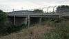 |
(#92000728) |
120th St. over the South Branch of Big Papillion Creek, 3.2 miles west of La Vista 41°10′27″N 96°06′01″W / 41.174167°N 96.100278°W |
La Vista | |
| 2 | Blacksmith Shop | Upload image | (#78001711) |
South of Bellevue on Offutt Air Force Base 41°07′11″N 95°55′24″W / 41.119722°N 95.923333°W |
Bellevue | |
| 3 | Champe-Fremont 1 Archeological Site | Upload image | (#75001091) |
Immediately south of the Douglas County line atop bluffs overlooking the Elkhorn River[5] 41°11′22″N 96°17′40″W / 41.189444°N 96.294444°W |
Gretna | Location is that of the Fremont 1 Site; Champe is located in Douglas County[5] |
| 4 | Fontenelle Bank | 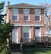 |
(#69000136) |
2212 Main St. 41°08′12″N 95°53′28″W / 41.13666°N 95.89123°W |
Bellevue | |
| 5 | Fontenelle Forest Historic District |  |
(#74001139) |
1111 Bellevue Blvd N.[6] 41°10′47″N 95°55′04″W / 41.17974°N 95.91776°W |
Bellevue | |
| 6 | Fort Crook Historic District | Upload image | (#76001139) |
Southwest of Bellevue on Offutt Air Force Base 41°07′23″N 95°55′21″W / 41.123056°N 95.9225°W |
Bellevue | |
| 7 | William E. Gordon House | |
(#06000997) |
711 Bellevue Boulevard, S. 41°09′14″N 95°53′58″W / 41.15375°N 95.89953°W |
Bellevue | |
| 8 | William Hamilton House | _from_SW_1.JPG) |
(#69000137) |
2003 Bluff St. 41°08′21″N 95°53′17″W / 41.13919°N 95.88807°W |
Bellevue | |
| 9 | Kurz Omaha Village | Upload image | (#73001073) |
Address Restricted |
Papillion | |
| 10 | Linoma Beach |  |
(#03000107) |
17106 S. 255th St. 41°03′44″N 96°19′08″W / 41.062222°N 96.318889°W |
Gretna | |
| 11 | McCarty-Lilley House | Upload image | (#78001712) |
West of Bellevue on Quail Dr. 41°08′07″N 95°58′20″W / 41.135278°N 95.972222°W |
Bellevue | |
| 12 | Moses Merrill Mission and Oto Indian Village | Upload image | (#72000757) |
Address Restricted |
La Platte | |
| 13 | Old Log Cabin | 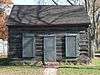 |
(#70000376) |
1805 Hancock St. 41°08′28″N 95°53′31″W / 41.14123°N 95.89186°W |
Bellevue | |
| 14 | Patterson Site | Upload image | (#07000176) |
Address Restricted 41°02′33″N 96°15′15″W / 41.0425°N 96.254167°W |
South Bend | |
| 15 | Presbyterian Church | 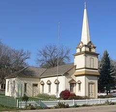 |
(#70000377) |
2002 Franklin St. 41°08′22″N 95°53′39″W / 41.13933°N 95.89404°W |
Bellevue | |
| 16 | Peter A. Sarpy Trading Post Site | Upload image | (#75001102) |
Address Restricted |
Bellevue | |
| 17 | John Sautter Farmhouse |  |
(#80002463) |
220 N. Jefferson St. 41°09′28″N 96°02′29″W / 41.157778°N 96.041389°W |
Papillion | |
| 18 | Springfield Community Hall | 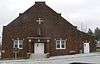 |
(#98000893) |
104 Main St. 41°04′56″N 96°08′04″W / 41.08218°N 96.13437°W |
Springfield | |
| 19 | Third Sarpy County Courthouse | 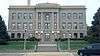 |
(#90000964) |
3rd St. between Washington and Jefferson Sts. 41°09′31″N 96°02′31″W / 41.158611°N 96.041944°W |
Papillion | |
| 20 | Zweibel Farmstead | 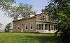 |
(#00001377) |
16302 S. 63rd St. 41°04′29″N 96°00′42″W / 41.074722°N 96.011667°W |
Papillion |
Former listing
| [3] | Name on the Register | Image | Date listed | Date removed | Location | City or town | Summary |
|---|---|---|---|---|---|---|---|
| 1 | Burlington Depot | Upload image | (#70000375) | Haworth Park |
Bellevue | Relocated to Sarpy County Museum Grounds at Gemini Park |
See also
| Wikimedia Commons has media related to National Register of Historic Places in Sarpy County, Nebraska. |
- List of National Historic Landmarks in Nebraska
- National Register of Historic Places listings in Nebraska
References
- ↑ The latitude and longitude information provided in this table was derived originally from the National Register Information System, which has been found to be fairly accurate for about 99% of listings. For about 1% of NRIS original coordinates, experience has shown that one or both coordinates are typos or otherwise extremely far off; some corrections may have been made. A more subtle problem causes many locations to be off by up to 150 yards, depending on location in the country: most NRIS coordinates were derived from tracing out latitude and longitudes off of USGS topographical quadrant maps created under the North American Datum of 1927, which differs from the current, highly accurate WGS84 GPS system used by most on-line maps. Chicago is about right, but NRIS longitudes in Washington are higher by about 4.5 seconds, and are lower by about 2.0 seconds in Maine. Latitudes differ by about 1.0 second in Florida. Some locations in this table may have been corrected to current GPS standards.
- ↑ "National Register of Historic Places: Weekly List Actions". National Park Service, United States Department of the Interior. Retrieved on December 16, 2016.
- 1 2 Numbers represent an ordering by significant words. Various colorings, defined here, differentiate National Historic Landmarks and historic districts from other NRHP buildings, structures, sites or objects.
- ↑ The eight-digit number below each date is the number assigned to each location in the National Register Information System database, which can be viewed by clicking the number.
- 1 2 Hill, A.T., and Paul Cooper. "The Champe Site: Excavation of a Prehistoric House in Douglas County, Nebraska." Nebraska History Magazine 17.4 (1936): 253-270: 253.
- ↑ "Fontenelle Forest". Fontenelle Nature Association website. Retrieved 2012-10-29.
| Topics | |
|---|---|
| Lists by states |
|
| Lists by insular areas | |
| Lists by associated states | |
| Other areas | |
| |
Municipalities and communities of Sarpy County, Nebraska, United States | ||
|---|---|---|
| Cities | ||
| CDPs | ||
| Other unincorporated communities | ||
This article is issued from Wikipedia - version of the 6/6/2016. The text is available under the Creative Commons Attribution/Share Alike but additional terms may apply for the media files.