National Register of Historic Places listings in Powhatan County, Virginia

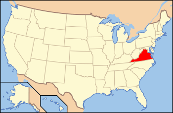
Location of Powhatan County in Virginia
This is a list of the National Register of Historic Places listings in Powhatan County, Virginia.
This is intended to be a complete list of the properties and districts on the National Register of Historic Places in Powhatan County, Virginia, United States. The locations of National Register properties and districts for which the latitude and longitude coordinates are included below, may be seen in a Google map.[1]
There are 20 properties and districts listed on the National Register in the county.
- This National Park Service list is complete through NPS recent listings posted December 2, 2016.[2]
Current listings
| [3] |
Name on the Register[4] |
Image |
Date listed[5] |
Location |
City or town |
Description |
|---|
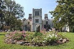
| 1 |
Beaumont |
Upload image |
000000001987-04-02-0000April 2, 1987
(#87000571) |
VA 313
37°40′04″N 77°54′46″W / 37.667778°N 77.912778°W / 37.667778; -77.912778 (Beaumont) |
Michaux |
|
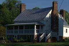
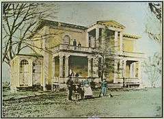
| 2 |
Belmead |
|
000000001969-11-12-0000November 12, 1969
(#69000270) |
NW of jct. of Rtes. 663 and 600
37°37′24″N 77°58′45″W / 37.623333°N 77.979167°W / 37.623333; -77.979167 (Belmead) |
Powhatan |
|
| 3 |
Belnemus |
|
000000001979-04-20-0000April 20, 1979
(#79003069) |
W of Powhatan off U.S. 60
37°34′03″N 77°59′48″W / 37.5675°N 77.996667°W / 37.5675; -77.996667 (Belnemus) |
Powhatan |
|
| 4 |
Blenheim |
Upload image |
000000001986-12-11-0000December 11, 1986
(#86003475) |
6177 Blenheim Rd.
37°30′49″N 78°05′04″W / 37.513611°N 78.084444°W / 37.513611; -78.084444 (Blenheim) |
Ballsville |
|
| 5 |
Elmington |
Upload image |
000000002005-01-20-0000January 20, 2005
(#04001538) |
3277 Maidens Rd.
37°36′30″N 77°55′45″W / 37.608333°N 77.929167°W / 37.608333; -77.929167 (Elmington) |
Powhatan |
|
| 6 |
Emmanuel Episcopal Church |
|
000000001990-12-27-0000December 27, 1990
(#90001924) |
Emmanuel Church Rd. S of US 60
37°33′36″N 77°57′17″W / 37.56°N 77.954722°W / 37.56; -77.954722 (Emmanuel Episcopal Church) |
Powhatan |
|
| 7 |
Fighting Creek Plantation |
|
000000002013-12-03-0000December 3, 2013
(#13000890) |
1811 Mill Quarter Rd.
37°31′06″N 77°54′48″W / 37.518342°N 77.913409°W / 37.518342; -77.913409 (Fighting Creek Plantation) |
Powhatan |
|
| 8 |
Fine Creek Mills Historic District |
Upload image |
000000002004-01-16-0000January 16, 2004
(#03001440) |
2425-2434 Robert E. Lee Rd. (VA 641)
37°36′01″N 77°49′05″W / 37.600278°N 77.818056°W / 37.600278; -77.818056 (Fine Creek Mills Historic District) |
Fine Creek Mills |
|
| 9 |
French's Tavern |
Upload image |
000000001989-04-21-0000April 21, 1989
(#89000293) |
6100 Old Buckingham Rd.
37°29′34″N 78°04′58″W / 37.492778°N 78.082778°W / 37.492778; -78.082778 (French's Tavern) |
Ballsville |
|
| 10 |
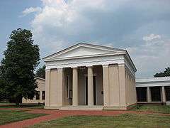
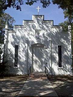
Huguenot Memorial Chapel and Monument |
|
000000001988-03-23-0000March 23, 1988
(#88000214) |
VA 711
37°33′53″N 77°42′33″W / 37.564722°N 77.709167°W / 37.564722; -77.709167 (Huguenot Memorial Chapel and Monument) |
Manakin |
|
| 11 |
Keswick |
|
000000001974-12-19-0000December 19, 1974
(#74002144) |
NE of Powhatan off VA 711
37°33′39″N 77°39′52″W / 37.560833°N 77.664444°W / 37.560833; -77.664444 (Keswick) |
Powhatan |
|
| 12 |
Mosby Tavern |
|
000000002003-04-11-0000April 11, 2003
(#03000214) |
2625 Old Tavern Rd.
37°33′53″N 78°02′16″W / 37.564722°N 78.037778°W / 37.564722; -78.037778 (Mosby Tavern) |
Powhatan |
|
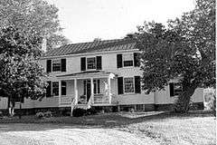
| 13 |
Norwood |
|
000000001980-05-19-0000May 19, 1980
(#80004212) |
NE of Powhatan
37°35′05″N 77°44′38″W / 37.584722°N 77.743889°W / 37.584722; -77.743889 (Norwood) |
Powhatan |
|
| 14 |
Paxton |
Upload image |
000000001990-12-28-0000December 28, 1990
(#90001987) |
3032 Genito Rd.
37°27′47″N 77°51′36″W / 37.463056°N 77.86°W / 37.463056; -77.86 (Paxton) |
Powhatan |
|
| 15 |
Powhatan Courthouse Historic District |
|
000000001970-02-16-0000February 16, 1970
(#70000821) |
Jct. of Rtes. 13 and 300
37°32′29″N 77°55′09″W / 37.541389°N 77.919167°W / 37.541389; -77.919167 (Powhatan Courthouse Historic District) |
Powhatan |
|
| 16 |
Provost |
Upload image |
000000001999-12-22-0000December 22, 1999
(#99001603) |
4801 Cartersville Rd.
37°36′03″N 77°59′02″W / 37.600833°N 77.983889°W / 37.600833; -77.983889 (Provost) |
Powhatan |
|
| 17 |
Red Lane Tavern |
|
000000002002-01-24-0000January 24, 2002
(#01001516) |
3009 Lower Hill Rd.
37°31′46″N 77°51′29″W / 37.529444°N 77.858056°W / 37.529444; -77.858056 (Red Lane Tavern) |
Powhatan |
|
| 18 |
Rosemont |
Upload image |
000000002008-05-29-0000May 29, 2008
(#08000482) |
4747 Cosby Rd.
37°36′22″N 77°58′42″W / 37.606008°N 77.978378°W / 37.606008; -77.978378 (Rosemont) |
Powhatan |
|
| 19 |
Somerset |
Upload image |
000000002006-09-06-0000September 6, 2006
(#06000804) |
2310 Ballsville Rd.
37°32′59″N 78°05′17″W / 37.549722°N 78.088056°W / 37.549722; -78.088056 (Somerset) |
Powhatan |
|
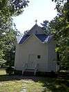
| 20 |
St. Luke's Episcopal Church |
Upload image |
000000001989-03-29-0000March 29, 1989
(#89000193) |
2245 Huguenot Trail
37°35′39″N 77°48′03″W / 37.594167°N 77.800833°W / 37.594167; -77.800833 (St. Luke's Episcopal Church) |
Fine Creek Mills |
|
See also
References
- ↑ The latitude and longitude information provided in this table was derived originally from the National Register Information System, which has been found to be fairly accurate for about 99% of listings. For about 1% of NRIS original coordinates, experience has shown that one or both coordinates are typos or otherwise extremely far off; some corrections may have been made. A more subtle problem causes many locations to be off by up to 150 yards, depending on location in the country: most NRIS coordinates were derived from tracing out latitude and longitudes off of USGS topographical quadrant maps created under the North American Datum of 1927, which differs from the current, highly accurate WGS84 GPS system used by most on-line maps. Chicago is about right, but NRIS longitudes in Washington are higher by about 4.5 seconds, and are lower by about 2.0 seconds in Maine. Latitudes differ by about 1.0 second in Florida. Some locations in this table may have been corrected to current GPS standards.
- ↑ "National Register of Historic Places: Weekly List Actions". National Park Service, United States Department of the Interior. Retrieved on December 2, 2016.
- ↑ Numbers represent an ordering by significant words. Various colorings, defined here, differentiate National Historic Landmarks and historic districts from other NRHP buildings, structures, sites or objects.
- ↑ National Park Service (2008-04-24). "National Register Information System". National Register of Historic Places. National Park Service.
- ↑ The eight-digit number below each date is the number assigned to each location in the National Register Information System database, which can be viewed by clicking the number.
|
|---|
|
Lists
by county | | |
|---|
|
Lists
by city | |
|---|
|
| Other lists | |
|---|
|
|
.jpg)
%2C_State_Route_711_vicinity%2C_Huguenot_vicinity_(Powhatan_County%2C_Virginia).jpg)
.jpg)