National Register of Historic Places listings in Narragansett, Rhode Island
This is a list of Registered Historic Places in Narragansett, Rhode Island.
- This National Park Service list is complete through NPS recent listings posted December 2, 2016.[1]
| [2] |
Name on the Register[3] |
Image |
Date listed[4] |
Location |
City or town |
Description |
|---|
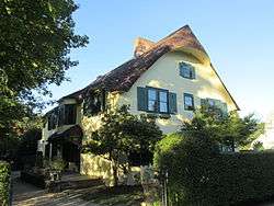
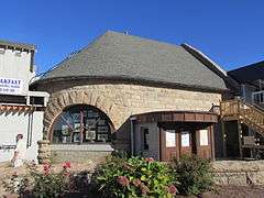
| 1 |
Anthony-Kinney Farm |
Upload image |
000000002013-04-17-0000April 17, 2013
(#13000178) |
505 Point Judith Road
41°24′26″N 71°28′44″W / 41.407219°N 71.478977°W / 41.407219; -71.478977 (Anthony-Kinney Farm) |
Narragansett |
|
| 2 |
Central Street Historic District |
|
000000001982-08-18-0000August 18, 1982
(#82000015) |
Both sides of Central Street from 5th Ave. to Boon St.
41°25′46″N 71°27′44″W / 41.429444°N 71.462222°W / 41.429444; -71.462222 (Central Street Historic District) |
Narragansett |
|
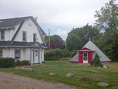
| 3 |
Druidsdream |
Upload image |
000000001989-07-20-0000July 20, 1989
(#89000940) |
144 Gibson Ave.
41°25′02″N 71°27′46″W / 41.417222°N 71.462778°W / 41.417222; -71.462778 (Druidsdream) |
Narragansett |
|
| 4 |
The Dunes Club |
|
000000002015-05-18-0000May 18, 2015
(#15000243) |
137 Boston Neck Rd.
41°26′23″N 71°26′56″W / 41.4398°N 71.4488°W / 41.4398; -71.4488 (The Dunes Club) |
Narragansett |
|
| 5 |
Dunmere |
Upload image |
000000002005-09-23-0000September 23, 2005
(#05001061) |
560 Ocean Rd.
41°24′16″N 71°27′44″W / 41.404444°N 71.462222°W / 41.404444; -71.462222 (Dunmere) |
Narragansett |
|
| 6 |
Earlscourt Historic District |
|
000000001982-08-18-0000August 18, 1982
(#82000017) |
Roughly bounded by Westmoreland, Noble, Woodward Sts., and Gibson Ave.(both sides)
41°25′15″N 71°27′42″W / 41.420833°N 71.461667°W / 41.420833; -71.461667 (Earlscourt Historic District) |
Narragansett |
|
| 7 |
Gardencourt |
|
000000001982-08-18-0000August 18, 1982
(#82000018) |
10 Gibson Ave.
41°25′21″N 71°27′39″W / 41.4225°N 71.460833°W / 41.4225; -71.460833 (Gardencourt) |
Narragansett |
|
| 8 |
Gladstone Springhouse and Bottling Plant |
|
000000001984-05-10-0000May 10, 1984
(#84002051) |
145A Boon St.
41°25′35″N 71°27′25″W / 41.426389°N 71.456944°W / 41.426389; -71.456944 (Gladstone Springhouse and Bottling Plant) |
Narragansett |
|
| 9 |
Greene Inn |
|
000000001976-06-24-0000June 24, 1976
(#76000009) |
175 Ocean Rd.
41°25′23″N 71°27′23″W / 41.423056°N 71.456389°W / 41.423056; -71.456389 (Greene Inn) |
Narragansett |
Burned down in 1980.
|
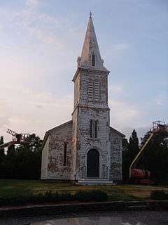
| 10 |
Narragansett Baptist Church |
|
000000001977-11-25-0000November 25, 1977
(#77000010) |
S. Ferry Rd.
41°29′34″N 71°25′34″W / 41.492778°N 71.426111°W / 41.492778; -71.426111 (Narragansett Baptist Church) |
Narragansett |
|
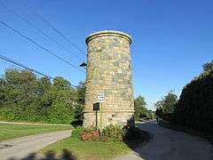
| 11 |
Narragansett Pier Life Saving Station |
|
000000001976-06-30-0000June 30, 1976
(#76000010) |
40 Ocean Rd.
41°25′48″N 71°27′20″W / 41.43°N 71.455556°W / 41.43; -71.455556 (Narragansett Pier Life Saving Station) |
Narragansett |
|
| 12 |
Ocean Road Historic District |
|
000000001982-08-18-0000August 18, 1982
(#82000019) |
Ocean and Wildfield Farm Rds., and Newton and Hazard Aves.
41°24′45″N 71°27′22″W / 41.4125°N 71.456111°W / 41.4125; -71.456111 (Ocean Road Historic District) |
Narragansett |
|
| 13 |
Point Judith Lighthouse |
|
000000001988-03-30-0000March 30, 1988
(#88000279) |
1470 Ocean Rd.
41°21′39″N 71°28′55″W / 41.360833°N 71.481944°W / 41.360833; -71.481944 (Point Judith Lighthouse) |
Narragansett |
|
| 14 |
Towers Historic District |
|
000000001982-08-18-0000August 18, 1982
(#82000021) |
Bounded by the Atlantic Ocean, Exchange Pl., and Mathewson and Taylor Sts.
41°25′48″N 71°27′23″W / 41.43°N 71.456389°W / 41.43; -71.456389 (Towers Historic District) |
Narragansett |
|
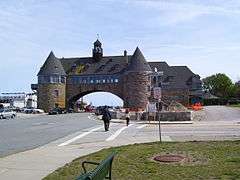
| 15 |
The Towers |
|
000000001969-11-25-0000November 25, 1969
(#69000001) |
Ocean Rd.
41°25′50″N 71°27′22″W / 41.430556°N 71.456111°W / 41.430556; -71.456111 (The Towers) |
Narragansett |
|
See also
References
|
|---|
|
| Topics | | |
|---|
|
| Lists by county | |
|---|
|
| Lists by city | Bristol Coutny | |
|---|
| Kent County | |
|---|
| Newport County | |
|---|
| Providence County | |
|---|
| Washington County | |
|---|
|
|---|
|
-
 Category Category
-
 NRHP portal NRHP portal
- Massachusetts portal
|
.jpg)

.jpg)


_(extra_close)_(US48).svg.png)