| [2] |
Name on the Register[3] |
Image |
Date listed[4] |
Location |
City or town |
Description |
|---|
| 1 |
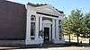
Bank of Osceola |
|
000000001987-08-06-0000August 6, 1987
(#87001352) |
207 E. Hale St.
35°42′10″N 89°58′00″W / 35.702778°N 89.966667°W / 35.702778; -89.966667 (Bank of Osceola) |
Osceola |
|
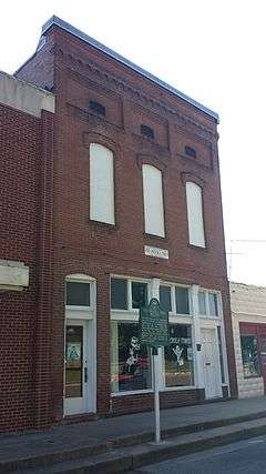
| 2 |
Blytheville Air Force Base Capehart Housing Historic District |
Upload image |
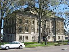
000000002015-09-28-0000September 28, 2015
(#15000628) |
Roughly bounded by Village Ave., Northside, Cypress Dr., Hemlock, Westminster, Apricot, Azalea & Pigeon Sts.
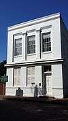
35°57′58″N 89°57′43″W / 35.9661°N 89.962°W / 35.9661; -89.962 (Blytheville Air Force Base Capehart Housing Historic District) |
Blytheville |
|
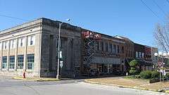
| 3 |
Blytheville Commercial Historic District |
|
000000002006-05-24-0000May 24, 2006
(#06000421) |
Main St. between 5th and Franklin Sts. and Ash St. between 5th and 2nd Sts.
35°55′44″N 89°54′20″W / 35.928889°N 89.905556°W / 35.928889; -89.905556 (Blytheville Commercial Historic District) |
Blytheville |
|
| 4 |
Blytheville Greyhound Bus Station |
|
000000001987-08-17-0000August 17, 1987
(#87000447) |
109 N. 5th St.
35°55′41″N 89°54′30″W / 35.928194°N 89.908333°W / 35.928194; -89.908333 (Blytheville Greyhound Bus Station) |
Blytheville |
|
| 5 |
Blytheville, Leachville and Arkansas Southern Railroad Depot-Leachville |
Upload image |
000000001992-06-11-0000June 11, 1992
(#92000612) |
Northeastern corner of the junction of 2nd and McNamee Sts.
35°56′15″N 90°15′33″W / 35.9375°N 90.259167°W / 35.9375; -90.259167 (Blytheville, Leachville and Arkansas Southern Railroad Depot-Leachville) |
Leachville |
|
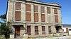
| 6 |
Burdette School Complex Historic District |
Upload image |
000000002001-10-28-0000October 28, 2001
(#01001174) |
153 E. Park Ln.
35°48′47″N 89°56′13″W / 35.813056°N 89.936944°W / 35.813056; -89.936944 (Burdette School Complex Historic District) |
Burdette |
burned, 9-20-2015
|
| 7 |
Chickasawba Mound (3M55) |
|
000000001984-11-16-0000November 16, 1984
(#84000217) |
North of the junction of Highway 151 and Chickasawba Ave.[5]
35°55′54″N 89°55′50″W / 35.931667°N 89.930556°W / 35.931667; -89.930556 (Chickasawba Mound (3M55)) |
Blytheville |
|
| 8 |
City Hall |
|
000000001987-08-06-0000August 6, 1987
(#87001350) |
316 W. Hale St.
35°42′10″N 89°58′15″W / 35.702778°N 89.970833°W / 35.702778; -89.970833 (City Hall) |
Osceola |
|
| 9 |
Delta Valley & Southern Railway Locomotive #50 |
Upload image |
000000002007-01-24-0000January 24, 2007
(#06001263) |
U.S. Route 61 at the Delta Valley and Southern Railway crossing
35°33′15″N 90°05′03″W / 35.554167°N 90.084167°W / 35.554167; -90.084167 (Delta Valley & Southern Railway Locomotive #50) |
Delpro |
Last known location Oklahoma City, Oklahoma, May 2009
|
| 10 |
Dyess Colony Center |
|
000000001976-01-01-0000January 1, 1976
(#76000435) |
Highway 297
35°35′29″N 90°12′46″W / 35.591389°N 90.212778°W / 35.591389; -90.212778 (Dyess Colony Center) |
Dyess |
|
| 11 |
Eaker Site |
|
000000001992-11-25-0000November 25, 1992
(#91001048) |
Northwest of the former landfill at Eaker Air Force Base[6]
35°57′48″N 89°56′04″W / 35.963333°N 89.934444°W / 35.963333; -89.934444 (Eaker Site) |
Blytheville |
|
| 12 |
Florida Brothers Building |
|
000000001987-08-06-0000August 6, 1987
(#87001355) |
319 W. Hale St.
35°42′09″N 89°58′15″W / 35.7025°N 89.970833°W / 35.7025; -89.970833 (Florida Brothers Building) |
Osceola |
|
| 13 |
Garden Point Cemetery |
Upload image |
000000002006-05-24-0000May 24, 2006
(#06000415) |
4682 W. Highway 140
35°42′08″N 90°14′17″W / 35.702222°N 90.238056°W / 35.702222; -90.238056 (Garden Point Cemetery) |
Etowah |
|
| 14 |
Hale Avenue Historic District |
|
000000001987-09-14-0000September 14, 1987
(#87001349) |
Roughly bounded by Hale Ave., Poplar St., Ford Ave., and Walnut St.; also roughly 107-111 W. Hale Ave. and 101-109 N. Walnut St.; also the 100 and 200 blocks of W. Hale Ave., the 100 and 200 blocks of E. Hale Ave., and the 100 block of N. Poplar St.
35°42′09″N 89°58′10″W / 35.7025°N 89.969444°W / 35.7025; -89.969444 (Hale Avenue Historic District) |
Osceola |
Second and third sets of addresses represent boundary increases of 000000002003-09-02-0000September 2, 2003 and 000000002008-08-01-0000August 1, 2008
|
| 15 |
Herman Davis Memorial |
|
000000001995-04-07-0000April 7, 1995
(#95000379) |
Northeastern corner of the junction of Baltimore Avenue (Highway 18B) and Highway 18
35°52′23″N 90°09′57″W / 35.873056°N 90.165833°W / 35.873056; -90.165833 (Herman Davis Memorial) |
Manila |
|
| 16 |
Jonesboro, Lake City & Eastern Railroad Depot |
Upload image |
000000001997-03-08-0000March 8, 1997
(#97000206) |
Northwestern corner of the junction of S. Dewey and Baltimore Avenue (Highway 18B)
35°52′43″N 90°10′00″W / 35.878611°N 90.166667°W / 35.878611; -90.166667 (Jonesboro, Lake City & Eastern Railroad Depot) |
Manila |
|
| 17 |
Keiser School |
Upload image |
000000001992-10-08-0000October 8, 1992
(#92001342) |
Southeastern corner of the junction of Main and School Sts.
35°40′26″N 90°05′42″W / 35.673889°N 90.095°W / 35.673889; -90.095 (Keiser School) |
Keiser |
|
| 18 |
Keiser Water Tower |
Upload image |
000000002007-01-24-0000January 24, 2007
(#06001283) |
Junction of Water and E. Main Sts.
35°40′39″N 90°05′50″W / 35.6775°N 90.097222°W / 35.6775; -90.097222 (Keiser Water Tower) |
Keiser |
|
| 19 |
Kress Building |
|
000000001997-06-13-0000June 13, 1997
(#97000555) |
210 W. Main St.
35°55′40″N 89°53′37″W / 35.927778°N 89.893611°W / 35.927778; -89.893611 (Kress Building) |
Blytheville |
|
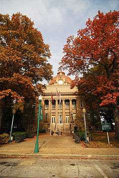
| 20 |
Mississippi County Courthouse |
|
000000001978-12-13-0000December 13, 1978
(#78000612) |
Hale and Poplar Aves.
35°42′11″N 89°58′09″W / 35.703056°N 89.969167°W / 35.703056; -89.969167 (Mississippi County Courthouse) |
Osceola |
|
| 21 |
Mississippi County Courthouse, Chickasawba District |
|
000000001996-12-06-0000December 6, 1996
(#96001411) |
200 W. Walnut St.
35°55′44″N 89°54′17″W / 35.928889°N 89.904722°W / 35.928889; -89.904722 (Mississippi County Courthouse, Chickasawba District) |
Blytheville |
|
| 22 |
Mississippi County Jail |
|
000000001987-08-06-0000August 6, 1987
(#87001356) |
300 S. Poplar St.
35°42′06″N 89°58′09″W / 35.701667°N 89.969167°W / 35.701667; -89.969167 (Mississippi County Jail) |
Osceola |
demolished 2-25-2016
|
| 23 |
Nodena Site |
|
000000001966-10-15-0000October 15, 1966
(#66000201) |
Address Restricted
|
Wilson |
An archeological site which is the type site for the Nodena culture. Possibly visited by Spanish explorer Hernando de Soto in 1542
|
| 24 |
Old Bell Telephone Building |
|
000000001987-08-06-0000August 6, 1987
(#87001353) |
100 block of Ash St.
35°42′12″N 89°57′59″W / 35.703333°N 89.966389°W / 35.703333; -89.966389 (Old Bell Telephone Building) |
Osceola |
|
| 25 |
Osceola Times Building |
|
000000001987-08-06-0000August 6, 1987
(#87001351) |
112 N. Poplar St.
35°42′11″N 89°58′07″W / 35.703056°N 89.968611°W / 35.703056; -89.968611 (Osceola Times Building) |
Osceola |
|
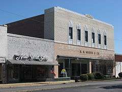
| 26 |
Planters Bank Building |
|
000000001987-08-06-0000August 6, 1987
(#87001354) |
200 E. Hale St.
35°42′09″N 89°58′01″W / 35.7025°N 89.966944°W / 35.7025; -89.966944 (Planters Bank Building) |
Osceola |
|
| 27 |
Three States Lumber Company Mill Powerhouse |
Upload image |
000000002001-10-28-0000October 28, 2001
(#01001175) |
Old Mill Rd.
35°49′00″N 89°56′24″W / 35.816667°N 89.94°W / 35.816667; -89.94 (Three States Lumber Company Mill Powerhouse) |
Burdette |
|
| 28 |
Chris Tompkins House |
Upload image |
000000002001-10-28-0000October 28, 2001
(#01001176) |
144 South Oak Dr.
35°48′57″N 89°56′19″W / 35.815833°N 89.938611°W / 35.815833; -89.938611 (Chris Tompkins House) |
Burdette |
|
| 29 |
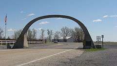
United States Highway 61 Arch |
|
000000002001-10-28-0000October 28, 2001
(#01001177) |
U.S. Route 61
35°59′58″N 89°53′54″W / 35.999522°N 89.898278°W / 35.999522; -89.898278 (United States Highway 61 Arch) |
Blytheville |
Extends into Pemiscot County, Missouri
|
| 30 |
Violet Cemetery |
|
000000002004-10-06-0000October 6, 2004
(#04001108) |
Area bounded by W. Johnson Ave., Semmes Ave., and Pecan St.
35°42′22″N 89°58′01″W / 35.706111°N 89.966944°W / 35.706111; -89.966944 (Violet Cemetery) |
Osceola |
|
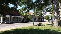
| 31 |
West Main Street Residential Historic District |
|
000000002010-08-05-0000August 5, 2010
(#10000521) |
W. Main St. between B and 6th St. and Division
35°55′39″N 89°55′08″W / 35.9275°N 89.918889°W / 35.9275; -89.918889 (West Main Street Residential Historic District) |
Blytheville |
|
| 32 |
Widner-Magers Farm Historic District |
Upload image |
000000002007-01-29-0000January 29, 2007
(#06001325) |
3398 Highway 181
35°52′41″N 90°02′38″W / 35.878056°N 90.043889°W / 35.878056; -90.043889 (Widner-Magers Farm Historic District) |
Dell |
|
| 33 |
Edward Samuel Wildy Barn |
Upload image |
000000002004-01-15-0000January 15, 2004
(#03001382) |
1198 S. Highway 136
35°43′07″N 90°14′33″W / 35.718611°N 90.2425°W / 35.718611; -90.2425 (Edward Samuel Wildy Barn) |
Etowah |
|
| 34 |
Wilson Commercial Historic District |
Upload image |
000000002016-09-23-0000September 23, 2016
(#16000651) |
Roughly bounded by Union Ave., S. Jefferson, Madison, Adams & 2nd Sts.
35°34′07″N 90°02′35″W / 35.568633°N 90.043066°W / 35.568633; -90.043066 (Wilson Commercial Historic District) |
Wilson |
|
| 35 |
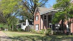
Wilson Community House |
Upload image |
000000002015-06-02-0000June 2, 2015
(#15000285) |
10 Lake Dr.
35°34′14″N 90°02′28″W / 35.5706°N 90.0411°W / 35.5706; -90.0411 (Wilson Community House) |
Wilson |
|
| 36 |
Wilson High School Gymnasium |
Upload image |
000000002015-05-27-0000May 27, 2015
(#15000286) |
Main & Lee Sts.
35°33′53″N 90°03′03″W / 35.5646°N 90.0507°W / 35.5646; -90.0507 (Wilson High School Gymnasium) |
Wilson |
|
| 37 |
Wilson Residential Historic District |
Upload image |
000000002016-09-21-0000September 21, 2016
(#16000652) |
4737, 4785, 4877 & 5101 US 61
35°35′02″N 90°02′00″W / 35.583774°N 90.033277°W / 35.583774; -90.033277 (Wilson Residential Historic District) |
Wilson |
|
| 38 |
Zebree Homestead |
Upload image |
000000001975-05-02-0000May 2, 1975
(#75000398) |
Section 28, T16N, R9E, in the Big Lake National Wildlife Refuge[7]:19
35°59′05″N 90°07′48″W / 35.984722°N 90.130000°W / 35.984722; -90.130000 (Zebree Homestead) |
Buckeye |
Mississippian village site.[7]:22 Located along the ditch at the refuge's western boundary; extends as far east as the old bed of the Little River[7]:25 |