| [3] |
Name on the Register[4] |
Image |
Date listed[5] |
Location |
City or town |
Description |
|---|
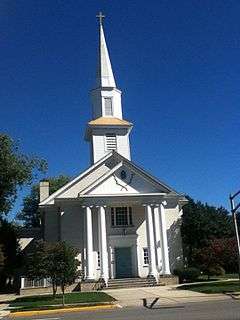
| 1 |
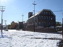
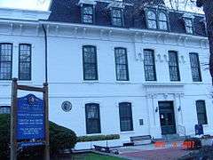
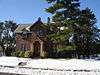
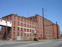
Thomas I. Agnew House |
|
000000001982-05-13-0000May 13, 1982
(#82003281) |
Memorial Pkwy.
40°29′03″N 74°25′13″W / 40.484167°N 74.420278°W / 40.484167; -74.420278 (Thomas I. Agnew House) |
New Brunswick |
|
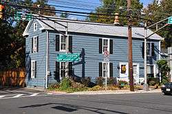
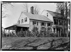
| 2 |
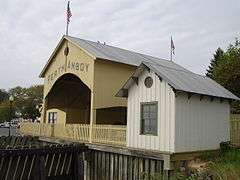
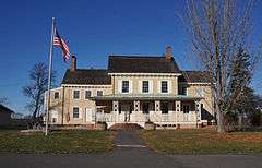
Ayers-Allen House |
|
000000001985-09-05-0000September 5, 1985
(#85002002) |
16 Durham Ave.
40°32′40″N 74°21′52″W / 40.544444°N 74.364444°W / 40.544444; -74.364444 (Ayers-Allen House) |
Metuchen |
|
| 3 |
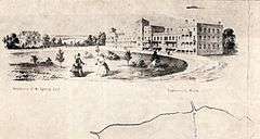
Barron Library |
|
000000001977-11-11-0000November 11, 1977
(#77000886) |
582 Rahway Ave.
40°33′39″N 74°16′28″W / 40.560833°N 74.274444°W / 40.560833; -74.274444 (Barron Library) |
Woodbridge |
|
| 4 |
James Bishop House |
|
000000001976-07-12-0000July 12, 1976
(#76001162) |
College Ave. near Bishop St.
40°30′11″N 74°27′00″W / 40.503056°N 74.45°W / 40.503056; -74.45 (James Bishop House) |
New Brunswick |
|
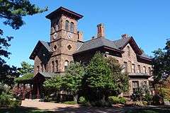
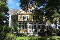
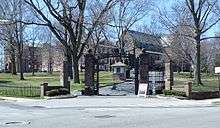
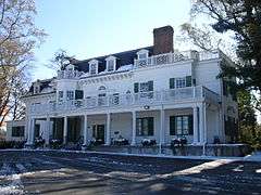
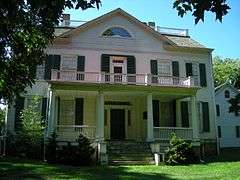
| 5 |
Buccleuch Mansion |
|
000000001977-04-13-0000April 13, 1977
(#77000883) |
200 College Ave., Buccleuch Park
40°30′18″N 74°27′37″W / 40.505°N 74.460278°W / 40.505; -74.460278 (Buccleuch Mansion) |
New Brunswick |
Built 1739
|
| 6 |
Cedar Brook Park |
|
000000002007-08-28-0000August 28, 2007
(#07000878) |
Roughly bounded Steel Ave., Arlington Ave., Park Ave., Rose St. and Laramie Rd., Kenyon Ave., Parkside Rd.
Coordinates missing |
South Plainfield |
|
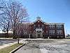
| 7 |
Cedar Grove School |
|
000000001976-10-24-0000October 24, 1976
(#76001165) |
E of Old Bridge on NJ 516
40°24′29″N 74°16′15″W / 40.408056°N 74.270833°W / 40.408056; -74.270833 (Cedar Grove School) |
Old Bridge |
|
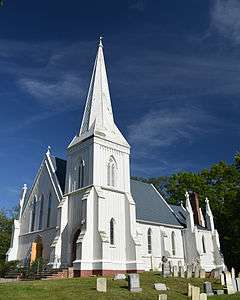
| 8 |
Christ Episcopal Church |
|
000000001989-07-28-0000July 28, 1989
(#89000994) |
5 Paterson St.
40°29′44″N 74°26′37″W / 40.495556°N 74.443611°W / 40.495556; -74.443611 (Christ Episcopal Church) |
New Brunswick |
Known as Christ Church
|
| 9 |
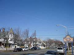
Cranbury Historic District |
|
000000001980-09-18-0000September 18, 1980
(#80002502) |
Main St.
40°18′47″N 74°30′55″W / 40.313100°N 74.515320°W / 40.313100; -74.515320 (Cranbury Historic District) |
Cranbury |
|
| 10 |
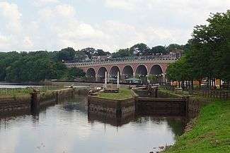
Delaware and Raritan Canal |
|
000000001973-05-11-0000May 11, 1973
(#73001105) |
Follows the Delaware River to Trenton, then E to New Brunswick
40°32′40″N 75°02′50″W / 40.544444°N 75.047222°W / 40.544444; -75.047222 (Delaware and Raritan Canal) |
New Brunswick |
Built 1830–34
|
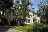
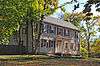
| 11 |
Demarest House |
|
000000001977-08-10-0000August 10, 1977
(#77000884) |
542 George St.
40°30′07″N 74°26′50″W / 40.501944°N 74.447222°W / 40.501944; -74.447222 (Demarest House) |
New Brunswick |
Built in 1867, now the Center on Violence Against Women and Children, Rutgers University
|
| 12 |
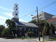
Dutch Reformed Church |
|
000000001988-09-27-0000September 27, 1988
(#88001703) |
160 Neilson St.
40°29′41″N 74°26′35″W / 40.494722°N 74.443056°W / 40.494722; -74.443056 (Dutch Reformed Church) |
New Brunswick |
Known as First Reformed Church
|
| 13 |
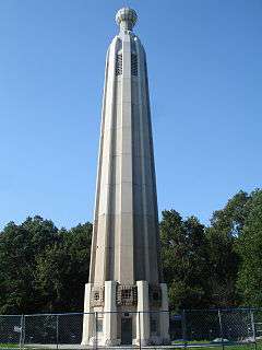
Thomas A. Edison Memorial Tower |
|
000000001979-11-30-0000November 30, 1979
(#79001505) |
37 Christie St.
40°33′47″N 74°20′22″W / 40.563056°N 74.339444°W / 40.563056; -74.339444 (Thomas A. Edison Memorial Tower) |
Edison |
Location of Edison's Menlo Park Laboratory, 1876-86. Memorial tower built 1938.
|
| 14 |
Ensley-Mount-Buckalew House |
|
000000001979-09-12-0000September 12, 1979
(#79001507) |
Buckalew Ave.
40°20′50″N 74°26′03″W / 40.347222°N 74.434167°W / 40.347222; -74.434167 (Ensley-Mount-Buckalew House) |
Jamesburg |
Known as Buckelew Mansion or Lakeview
|
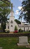
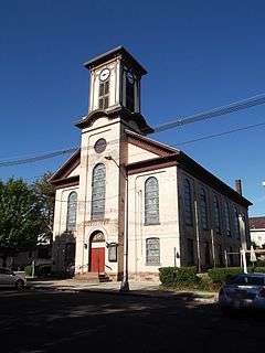
| 15 |
First Presbyterian Church and Cemetery |
|
000000002008-05-02-0000May 2, 2008
(#08000363) |
600 Rahway Ave.
40°33′43″N 74°16′26″W / 40.561944°N 74.273889°W / 40.561944; -74.273889 (First Presbyterian Church and Cemetery) |
Woodbridge |
|
| 16 |
Ephraim Fitz-Randolph House |
|
000000001973-03-14-0000March 14, 1973
(#73001114) |
430 S. Randolphville Road
40°32′56″N 74°27′45″W / 40.548889°N 74.4625°W / 40.548889; -74.4625 (Ephraim Fitz-Randolph House) |
Piscataway |
|
| 17 |
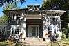
Goldman House |
|
000000002010-10-01-0000October 1, 2010
(#10000813) |
143 School St.
40°31′47″N 74°26′04″W / 40.5297°N 74.4344°W / 40.5297; -74.4344 (Goldman House) |
Piscataway |
At the Ferrer Colony
|
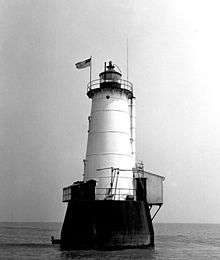
| 18 |
Great Beds Light |
|
000000002008-05-29-0000May 29, 2008
(#08000467) |
Offshore in Raritan Bay at NJ-NY line approx. 1 mi. E. of South Amboy
40°29′12″N 74°15′11″W / 40.486667°N 74.253056°W / 40.486667; -74.253056 (Great Beds Light) |
South Amboy |
|
| 19 |
Henry Guest House |
|
000000001976-05-24-0000May 24, 1976
(#76001163) |
58 Livingston Ave.
40°29′29″N 74°26′45″W / 40.491389°N 74.445833°W / 40.491389; -74.445833 (Henry Guest House) |
New Brunswick |
Built 1760
|
| 20 |
Gulick House |
|
000000001979-07-03-0000July 3, 1979
(#79001509) |
W of Monmouth Junction on Raymond Rd.
40°22′48″N 74°35′27″W / 40.38°N 74.590833°W / 40.38; -74.590833 (Gulick House) |
Monmouth Junction |
Known as Red Maple Farm
|
| 21 |
Helme, G. W., Snuff Mill District |
|
000000001980-08-15-0000August 15, 1980
(#80002503) |
Irregular pattern along Main St.
40°22′39″N 74°25′31″W / 40.3775°N 74.425278°W / 40.3775; -74.425278 (Helme, G. W., Snuff Mill District) |
Helmetta |
|
| 22 |
Holmes-Tallman House |
|
000000001979-09-12-0000September 12, 1979
(#79001508) |
NW of Jamesburg at Cranbury and Brown's Corner Rds.
40°22′15″N 74°27′30″W / 40.370833°N 74.458333°W / 40.370833; -74.458333 (Holmes-Tallman House) |
Jamesburg |
|
| 23 |
Homestead Farm at Oak Ridge |
|
000000001995-10-25-0000October 25, 1995
(#95001185) |
Jct. of Oak Ridge Rd. and Feather Bed Ln., Clark and Edison Townships
40°36′28″N 74°20′56″W / 40.607778°N 74.348889°W / 40.607778; -74.348889 (Homestead Farm at Oak Ridge) |
Clark |
|
| 24 |
George Inness House |
|
000000001979-10-10-0000October 10, 1979
(#79003250) |
313 Convery Blvd.
40°30′50″N 74°17′16″W / 40.513889°N 74.287778°W / 40.513889; -74.287778 (George Inness House) |
Perth Amboy |
The Eagleswood Mansion demolished 1993
|
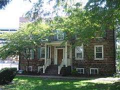
| 25 |
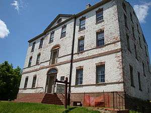
Ivy Hall |
|
000000001971-05-27-0000May 27, 1971
(#71000510) |
1225 River Road
40°30′45″N 74°27′45″W / 40.5125°N 74.4625°W / 40.5125; -74.4625 (Ivy Hall) |
Piscataway |
Known as Cornelius Low House
|
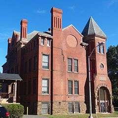
| 26 |
Levi D. Jarrard House |
|
000000001982-04-22-0000April 22, 1982
(#82003282) |
George St., Douglass College campus
40°29′11″N 74°26′16″W / 40.486389°N 74.437778°W / 40.486389; -74.437778 (Levi D. Jarrard House) |
New Brunswick |
Known as College Hall, Douglass Campus, Rutgers University
|
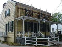
| 27 |
William H. Johnson House |
|
000000002006-07-12-0000July 12, 2006
(#06000560) |
52 Welton St.
40°29′29″N 74°26′38″W / 40.491389°N 74.443889°W / 40.491389; -74.443889 (William H. Johnson House) |
New Brunswick |
The house (c. 1870) is named for William H. Johnson (born 1829), the original owner who lived here until his death, February 26, 1904 with his wife Sarah and daughter Adilade.
|
| 28 |
Edward S. Kearney House |
|
000000001979-04-06-0000April 6, 1979
(#79001504) |
NJ 18
40°28′51″N 74°24′45″W / 40.480833°N 74.4125°W / 40.480833; -74.4125 (Edward S. Kearney House) |
East Brunswick |
|
| 29 |
Lawrence Kearny House |
|
000000001976-05-28-0000May 28, 1976
(#76001166) |
63 Catalpa St.
40°30′04″N 74°16′21″W / 40.501111°N 74.2725°W / 40.501111; -74.2725 (Lawrence Kearny House) |
Perth Amboy |
|
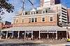
| 30 |
King Block |
Upload image |
000000001988-05-26-0000May 26, 1988
(#88000644) |
316-324 Memorial Pkwy.
40°29′44″N 74°26′26″W / 40.495556°N 74.440556°W / 40.495556; -74.440556 (King Block) |
New Brunswick |
Demolished early 1990s
|
| 31 |
King's Highway Historic District |
|
000000002000-12-21-0000December 21, 2000
(#00001493) |
NJ 27, US 206
40°22′21″N 74°37′06″W / 40.3725°N 74.618333°W / 40.3725; -74.618333 (King's Highway Historic District) |
South Brunswick |
|
| 32 |
Kingston Mill Historic District |
|
000000001986-04-10-0000April 10, 1986
(#86000707) |
Roughly bounded by Herrontown, River, Princeton-Kingston Rds., and lots W of Princeton Twp.
40°22′28″N 74°37′34″W / 40.374444°N 74.626111°W / 40.374444; -74.626111 (Kingston Mill Historic District) |
South Brunswick |
Kingston Bridge
|
| 33 |
Kingston Village Historic District |
|
000000001990-01-11-0000January 11, 1990
(#89002163) |
Roughly NJ 27 from Raymond Rd. to Delaware & Raritan Canal, Church St., Laurel Ave., Heathcote Brook Rd., & Academy St.
40°22′33″N 74°36′48″W / 40.375833°N 74.613333°W / 40.375833; -74.613333 (Kingston Village Historic District) |
Kingston |
|
| 34 |
Laing House of Plainfield Plantation |
|
000000001988-10-27-0000October 27, 1988
(#88002124) |
1707 Woodland Ave.
40°34′57″N 74°23′17″W / 40.5825°N 74.388056°W / 40.5825; -74.388056 (Laing House of Plainfield Plantation) |
Edison |
|
| 35 |
Livingston Avenue Historic District |
|
000000001996-02-16-0000February 16, 1996
(#96000072) |
Area surrounding Livingston Ave. between Half and Morris Sts.
40°29′21″N 74°26′53″W / 40.489167°N 74.448056°W / 40.489167; -74.448056 (Livingston Avenue Historic District) |
New Brunswick |
|
| 36 |
Livingston Homestead |
|
000000002002-03-20-0000March 20, 2002
(#02000215) |
81 Harrison Ave.
40°30′15″N 74°26′07″W / 40.504167°N 74.435278°W / 40.504167; -74.435278 (Livingston Homestead) |
Highland Park |
Livingston Manor Historic District
|
| 37 |
Livingston Manor Historic District |
|
000000002004-07-07-0000July 7, 2004
(#04000672) |
Roughly bounded by Cleveland, Grant, Harrison, Lawrence, Lincoln, Madison and N. 2nd Aves. and River Rd.
40°30′05″N 74°26′17″W / 40.501389°N 74.438056°W / 40.501389; -74.438056 (Livingston Manor Historic District) |
Highland Park |
|
| 38 |
Main Post Office |
|
000000001984-07-18-0000July 18, 1984
(#84002731) |
86 Bayard St.
40°29′36″N 74°26′47″W / 40.493333°N 74.446389°W / 40.493333; -74.446389 (Main Post Office) |
New Brunswick |
|
| 39 |
Metlar House |
|
000000001973-03-07-0000March 7, 1973
(#73001115) |
1281 River Road
40°30′45″N 74°27′25″W / 40.5125°N 74.456944°W / 40.5125; -74.456944 (Metlar House) |
Piscataway |
Originally part of the community at Raritan Landing, also known as the Metlar-Bodine House
|
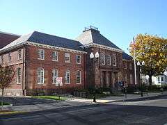
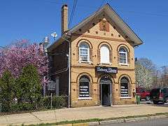
| 40 |
Metuchen Borough Hall |
Upload image |
000000002001-05-14-0000May 14, 2001
(#01000503) |
500 Main St.
40°32′38″N 74°21′47″W / 40.543889°N 74.363056°W / 40.543889; -74.363056 (Metuchen Borough Hall) |
Metuchen |
Demolished 2001–02
|
| 41 |
Milltown India Rubber Company |
|
000000001986-02-13-0000February 13, 1986
(#86000216) |
40 Washington Ave.
40°27′10″N 74°26′06″W / 40.452778°N 74.435°W / 40.452778; -74.435 (Milltown India Rubber Company) |
Milltown |
|
| 42 |
National Musical String Company |
|
000000001982-04-20-0000April 20, 1982
(#82003283) |
120 Georges Rd.
40°28′33″N 74°26′52″W / 40.475833°N 74.447778°W / 40.475833; -74.447778 (National Musical String Company) |
New Brunswick |
|
| 43 |
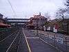
New Brunswick Station |
|
000000001984-06-22-0000June 22, 1984
(#84002732) |
French St. and Albany St.
40°29′47″N 74°26′47″W / 40.496389°N 74.446389°W / 40.496389; -74.446389 (New Brunswick Station) |
New Brunswick |
Built 1903 by Pennsylvania Railroad
|
| 44 |
New Jersey Hall |
|
000000001975-02-24-0000February 24, 1975
(#75001144) |
73 Hamilton St.
Rutgers University
40°29′58″N 74°26′51″W / 40.499444°N 74.4475°W / 40.499444; -74.4475 (New Jersey Hall) |
New Brunswick |
Located on the Voorhees Mall
|
| 45 |
Old Bridge Historic District |
|
000000001977-06-29-0000June 29, 1977
(#77000882) |
Main St.
40°24′53″N 74°21′54″W / 40.414848°N 74.365079°W / 40.414848; -74.365079 (Old Bridge Historic District) |
East Brunswick |
|
| 46 |
Old Cranbury School |
|
000000001971-06-21-0000June 21, 1971
(#71000508) |
23 N. Main St.
40°18′42″N 74°31′02″W / 40.311667°N 74.517222°W / 40.311667; -74.517222 (Old Cranbury School) |
Cranbury |
|
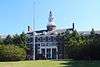
| 47 |
Old Queens, Rutgers University |
|
000000001976-05-11-0000May 11, 1976
(#76001164) |
83 Somerset St.
Rutgers University
40°29′58″N 74°26′51″W / 40.499444°N 74.4475°W / 40.499444; -74.4475 (Old Queens, Rutgers University) |
New Brunswick |
Built 1809–1823. Oldest building at Rutgers University, also part of Queens Campus
|
| 48 |
Old School Baptist Church and Cemetery |
|
000000001992-01-07-0000January 7, 1992
(#91001926) |
64-66 Main St.
40°27′01″N 74°22′54″W / 40.450278°N 74.381667°W / 40.450278; -74.381667 (Old School Baptist Church and Cemetery) |
South River |
|
| 49 |
Isaac Onderdonk House |
|
000000001973-10-30-0000October 30, 1973
(#73001116) |
685 River Road
40°31′57″N 74°29′36″W / 40.5325°N 74.493333°W / 40.5325; -74.493333 (Isaac Onderdonk House) |
Piscataway |
Part of Road Up Raritan Historic District
|
| 50 |
Perth Amboy City Hall and Surveyor General's Office |
|
000000001981-01-21-0000January 21, 1981
(#81000394) |
260 High St.
40°30′23″N 74°15′57″W / 40.506389°N 74.265833°W / 40.506389; -74.265833 (Perth Amboy City Hall and Surveyor General's Office) |
Perth Amboy |
|
| 51 |
Perth Amboy Ferry Slip |
|
000000001978-11-28-0000November 28, 1978
(#78001773) |
Smith St.
40°30′25″N 74°15′44″W / 40.506944°N 74.262222°W / 40.506944; -74.262222 (Perth Amboy Ferry Slip) |
Perth Amboy |
Former B&O ferry port to Tottenville, Staten Island
|
| 52 |
Perth Amboy Station |
|
000000001984-06-22-0000June 22, 1984
(#84002735) |
Between Smith and Market Sts.
40°30′34″N 74°16′26″W / 40.509444°N 74.273889°W / 40.509444; -74.273889 (Perth Amboy Station) |
Perth Amboy |
Built 1928
|
| 53 |
Poile Zedek Synagogue |
|
000000001995-10-25-0000October 25, 1995
(#95001189) |
145 Neilson St.
40°29′39″N 74°26′31″W / 40.494167°N 74.441944°W / 40.494167; -74.441944 (Poile Zedek Synagogue) |
New Brunswick |
|
| 54 |
Proprietary House |
|
000000001971-02-24-0000February 24, 1971
(#71000509) |
139-151 Kearny Ave.
40°30′44″N 74°16′10″W / 40.512222°N 74.269444°W / 40.512222; -74.269444 (Proprietary House) |
Perth Amboy |
|
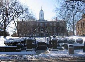
| 55 |
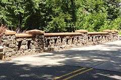
Queens Campus, Rutgers University |
|
000000001973-07-02-0000July 2, 1973
(#73001113) |
Bounded by College Ave. and George, Hamilton, and Somerset Sts.
40°29′54″N 74°26′48″W / 40.498333°N 74.446667°W / 40.498333; -74.446667 (Queens Campus, Rutgers University) |
New Brunswick |
Includes Old Queens (1809), Van Nest Hall (1845), Daniel S. Schanck Observatory (1865), Geology Hall (1872), Kirkpatrick Chapel (1873), Winants Hall (1890).
|
| 56 |
Randolphville Bridge |
|
000000001999-09-17-0000September 17, 1999
(#99001169) |
Near 618 S. Randolphville Road
40°32′22″N 74°27′11″W / 40.539444°N 74.453056°W / 40.539444; -74.453056 (Randolphville Bridge) |
Piscataway |
Built 1937
|
| 57 |
Raritan Landing Archeological District |
|
000000001979-08-10-0000August 10, 1979
(#79001506) |
Johnson Park
Coordinates missing |
Piscataway
Highland Park |
Excavations in conjunction with construction of Route 18
|
| 58 |
Road Up Raritan Historic District |
|
000000001997-09-18-0000September 18, 1997
(#97001146) |
Along River Road, from Ellis Parkway to 899 River Road
40°31′35″N 74°29′29″W / 40.526389°N 74.491389°W / 40.526389; -74.491389 (Road Up Raritan Historic District) |
Piscataway |
|
| 59 |
Roosevelt Hospital |
|
000000002002-03-05-0000March 5, 2002
(#02000109) |
1 Roosevelt Drive
40°33′04″N 74°20′16″W / 40.551111°N 74.337778°W / 40.551111; -74.337778 (Roosevelt Hospital) |
Edison |
|
| 60 |
Rutgers Preparatory School |
|
000000001975-07-18-0000July 18, 1975
(#75001145) |
101 Somerset St.
40°29′52″N 74°26′52″W / 40.497778°N 74.447778°W / 40.497778; -74.447778 (Rutgers Preparatory School) |
New Brunswick |
Designed and built by architect Nicholas Wyckoff, former home (1830–1963) of oldest independent school in New Jersey, established 1766. Building in New Brunswick now known as Alexander Johnston Hall on Rutgers University campus.
|
| 61 |
Saint Mary of Mount Virgin Roman Catholic Church |
|
000000002010-11-03-0000November 3, 2010
(#10000877) |
190 Sandford St.
40°29′02″N 74°26′59″W / 40.483889°N 74.449722°W / 40.483889; -74.449722 (Saint Mary of Mount Virgin Roman Catholic Church) |
New Brunswick |
|
| 62 |
St. Mary's Church |
|
000000002003-12-10-0000December 10, 2003
(#03001276) |
Jct. of Jackson St. and Whitehead Ave.
40°26′59″N 74°22′40″W / 40.449722°N 74.377778°W / 40.449722; -74.377778 (St. Mary's Church) |
South River |
|
| 63 |
Saint Peter the Apostle Church |
|
000000002005-11-25-0000November 25, 2005
(#05001332) |
94 Somerset St.
40°29′52″N 74°26′46″W / 40.4977°N 74.4461°W / 40.4977; -74.4461 (Saint Peter the Apostle Church) |
New Brunswick |
|
| 64 |
St. Peter's Episcopal Church |
|
000000001977-05-12-0000May 12, 1977
(#77000885) |
Rector and Gordon Sts.
40°30′14″N 74°15′57″W / 40.503858°N 74.265758°W / 40.503858; -74.265758 (St. Peter's Episcopal Church) |
Perth Amboy |
|
| 65 |
St. Peters Church and Buildings |
|
000000001979-10-10-0000October 10, 1979
(#79003251) |
Main St. and DeVoe Ave.
40°23′29″N 74°23′24″W / 40.391389°N 74.39°W / 40.391389; -74.39 (St. Peters Church and Buildings) |
Spotswood |
|
| 66 |
Sayre and Fisher Reading Room |
|
000000001979-09-12-0000September 12, 1979
(#79001511) |
Main St. and River Rd.
40°28′16″N 74°21′19″W / 40.471111°N 74.355278°W / 40.471111; -74.355278 (Sayre and Fisher Reading Room) |
Sayreville |
|
| 67 |
Short Hills Battlefield Historic District |
|
000000002014-05-09-0000May 9, 2014
(#14000203) |
Address Restricted
40°35′31″N 74°23′31″W / 40.5919801°N 74.3920027°W / 40.5919801; -74.3920027 (Short Hills Battlefield Historic District) |
Edison Township |
|
| 68 |
Benjamin Shotwell House |
|
000000001987-06-04-0000June 4, 1987
(#87000875) |
26 Runyon's Lane
40°32′50″N 74°24′16″W / 40.547222°N 74.404444°W / 40.547222; -74.404444 (Benjamin Shotwell House) |
Edison |
|
| 69 |
Simpson United Methodist Church |
|
000000001979-04-06-0000April 6, 1979
(#79001510) |
High and Jefferson Sts.
40°30′32″N 74°15′56″W / 40.508889°N 74.265556°W / 40.508889; -74.265556 (Simpson United Methodist Church) |
Perth Amboy |
|
| 70 |
Six Mile Run Historic District |
|
000000001995-10-25-0000October 25, 1995
(#95001191) |
Roughly bounded by Grouse Road, Amwell Road, Bennetts Lane, New Jersey Route 27, Bunker Hill Road and the Millstone River in Franklin Township, Somerset County
40°27′19″N 74°30′52″W / 40.455278°N 74.514444°W / 40.455278; -74.514444 (Six Mile Run Historic District) |
North Brunswick |
Only the eastern side of the Route 27 Bridge over the Six Mile Run is in Middlesex County.
|
| 71 |
Matthias Smock House |
|
000000001973-12-04-0000December 4, 1973
(#73001117) |
851 River Road
40°31′26″N 74°29′22″W / 40.523889°N 74.489444°W / 40.523889; -74.489444 (Matthias Smock House) |
Piscataway |
Part of Road Up Raritan Historic District
|
| 72 |
Trinity Episcopal Church |
|
000000002004-05-12-0000May 12, 2004
(#04000431) |
650 Rahway Ave.
40°33′43″N 74°16′23″W / 40.561944°N 74.273056°W / 40.561944; -74.273056 (Trinity Episcopal Church) |
Woodbridge |
Church and c. 1700 house
|
| 73 |
United States Post Office |
|
000000002008-04-02-0000April 2, 2008
(#08000270) |
360 Main St.
40°32′25″N 74°21′38″W / 40.540262°N 74.360619°W / 40.540262; -74.360619 (United States Post Office) |
Metuchen |
|
| 74 |
Joseph and Minnie White House |
|
000000001988-10-28-0000October 28, 1988
(#87001763) |
243 Hazelwood Ave.
40°34′15″N 74°31′12″W / 40.57075°N 74.519972°W / 40.57075; -74.519972 (Joseph and Minnie White House) |
Middlesex |
|
| 75 |
John Van Buren Wicoff House |
|
000000001998-03-12-0000March 12, 1998
(#98000236) |
641 Plainsboro Rd.
40°20′01″N 74°35′14″W / 40.333706°N 74.587103°W / 40.333706; -74.587103 (John Van Buren Wicoff House) |
Plainsboro |
|
| 76 |
Withington Estate |
|
000000001984-09-27-0000September 27, 1984
(#84002740) |
Spruce Lane
40°22′25″N 74°36′32″W / 40.373611°N 74.608889°W / 40.373611; -74.608889 (Withington Estate) |
Kingston |
|
| 77 |
Wood Lawn |
|
000000001978-03-08-0000March 8, 1978
(#78001772) |
Clifton Ave. and George St.
40°28′54″N 74°26′01″W / 40.481667°N 74.433611°W / 40.481667; -74.433611 (Wood Lawn) |
New Brunswick |
Now the Eagleton Institute of Politics, Cook/Douglass Campus, Rutgers University |


.jpg)