National Register of Historic Places listings in Madison County, Montana

Location of Madison County in Montana
This is a list of the National Register of Historic Places listings in Madison County, Montana. It is intended to be a complete list of the properties and districts on the National Register of Historic Places in Madison County, Montana, United States. The locations of National Register properties and districts for which the latitude and longitude coordinates are included below, may be seen in a map.[1]
There are 18 properties and districts listed on the National Register in the county, including 1 National Historic Landmark.
- This National Park Service list is complete through NPS recent listings posted December 16, 2016.[2]
Listings county-wide
| [3] |
Name on the Register |
Image |
Date listed[4] |
Location |
City or town |
Description |
|---|
| 1 |
Beaverhead Rock-Lewis and Clark Expedition |
|
000000001970-02-11-0000February 11, 1970
(#70000359) |
About 14 miles northeast of Dillon
45°23′18″N 112°27′29″W / 45.388333°N 112.458056°W / 45.388333; -112.458056 (Beaverhead Rock-Lewis and Clark Expedition) |
Dillon |
|
| 2 |
Dr. Don L. Byam House |
|
000000002002-03-01-0000March 1, 2002
(#02000103) |
Main St.
45°18′27″N 111°58′04″W / 45.3075°N 111.967778°W / 45.3075; -111.967778 (Dr. Don L. Byam House) |
Nevada City |
|
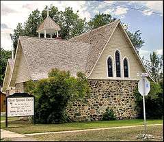
| 3 |
Christ Episcopal Church and Rectory |
|
000000001987-01-22-0000January 22, 1987
(#86003672) |
304 S. Main St.
45°27′13″N 112°11′45″W / 45.453611°N 112.195833°W / 45.453611; -112.195833 (Christ Episcopal Church and Rectory) |
Sheridan |
|
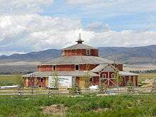
| 4 |
Doncaster Round Barn |
|
000000002015-04-14-0000April 14, 2015
(#15000150) |
Riverside Dr.
45°34′12″N 112°18′49″W / 45.570118°N 112.313718°W / 45.570118; -112.313718 (Doncaster Round Barn) |
Twin Bridges vicinity |
|
| 5 |
Ferris-Hermsmeyer-Fenton |
|
000000002008-01-09-0000January 9, 2008
(#07001364) |
144 Duncan District Rd.
Coordinates missing |
Sheridan |
|
| 6 |
Finney House |
|
000000002002-03-01-0000March 1, 2002
(#02000104) |
Junction of Main and California Sts.
45°18′28″N 111°58′05″W / 45.307778°N 111.968056°W / 45.307778; -111.968056 (Finney House) |
Nevada City |
|
| 7 |
Hutchins Bridge |
Upload image |
000000001999-03-18-0000March 18, 1999
(#99000344) |
Across the Madison River
44°53′20″N 111°34′47″W / 44.888889°N 111.579722°W / 44.888889; -111.579722 (Hutchins Bridge) |
Cameron |
|
| 8 |
Madison County Fairgrounds |
Upload image |
000000001984-08-03-0000August 3, 1984
(#84002500) |
Montana Highway 41
45°32′31″N 112°20′08″W / 45.541944°N 112.335556°W / 45.541944; -112.335556 (Madison County Fairgrounds) |
Twin Bridges |
|
| 9 |
William O'Brien House |
Upload image |
000000001986-10-23-0000October 23, 1986
(#86002933) |
114 E. Poppleton
45°27′16″N 112°11′40″W / 45.454444°N 112.194444°W / 45.454444; -112.194444 (William O'Brien House) |
Sheridan |
|
| 10 |
Pony Historic District |
|
000000001987-08-04-0000August 4, 1987
(#87001264) |
Community of Pony, southwest of Harrison
45°39′25″N 111°53′50″W / 45.656944°N 111.897222°W / 45.656944; -111.897222 (Pony Historic District) |
Pony |
|
| 11 |
Powder House |
|
000000001987-08-03-0000August 3, 1987
(#87001266) |
½ mile southeast of Pony on Potosi Rd.
45°39′22″N 111°52′33″W / 45.656111°N 111.875833°W / 45.656111; -111.875833 (Powder House) |
Pony |
|
| 12 |
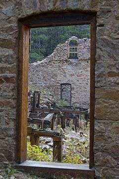
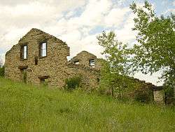
Robbers Roost |
Upload image |
000000001976-01-01-0000January 1, 1976
(#76001124) |
5 miles north of Alder at Montana Highway 387A
45°23′33″N 112°08′49″W / 45.3925°N 112.146944°W / 45.3925; -112.146944 (Robbers Roost) |
Alder |
|
| 13 |
H.D. Rossiter Building |
|
000000001994-03-07-0000March 7, 1994
(#94000138) |
115 S. Main St.
45°27′21″N 112°11′46″W / 45.455833°N 112.196111°W / 45.455833; -112.196111 (H.D. Rossiter Building) |
Sheridan |
|
| 14 |
Saint Mary of the Assumption |
|
000000001985-10-24-0000October 24, 1985
(#85003380) |
Off Montana Highway 287
45°21′15″N 112°06′26″W / 45.354167°N 112.107222°W / 45.354167; -112.107222 (Saint Mary of the Assumption) |
Laurin |
|
| 15 |
Strawberry Mine Historic District |
Upload image |
000000001987-08-04-0000August 4, 1987
(#87001265) |
Roughly bounded by Strawberry Ridge, Pony Rd., and Pony Creek
45°39′50″N 111°56′14″W / 45.663889°N 111.937222°W / 45.663889; -111.937222 (Strawberry Mine Historic District) |
Pony |
|
| 16 |
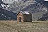
Thexton Ranch |
Upload image |
000000002006-05-12-0000May 12, 2006
(#06000426) |
335 Varney Rd.
45°16′53″N 111°45′44″W / 45.28132°N 111.76214°W / 45.28132; -111.76214 (Thexton Ranch) |
Ennis |
|
| 17 |
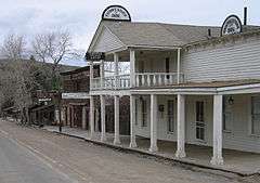
Union City |
|
000000001999-02-26-0000February 26, 1999
(#99000261) |
Southeast of Virginia City[5]
45°12′30″N 111°56′03″W / 45.208333°N 111.934167°W / 45.208333; -111.934167 (Union City) |
Virginia City |
An abandoned mining camp[6]
|
| 18 |
Virginia City Historic District |
|
000000001966-10-15-0000October 15, 1966
(#66000435) |
Wallace St.
45°17′27″N 111°56′35″W / 45.290833°N 111.943056°W / 45.290833; -111.943056 (Virginia City Historic District) |
Virginia City |
|
See also
References
- ↑ The latitude and longitude information provided in this table was derived originally from the National Register Information System, which has been found to be fairly accurate for about 99% of listings. For about 1% of NRIS original coordinates, experience has shown that one or both coordinates are typos or otherwise extremely far off; some corrections may have been made. A more subtle problem causes many locations to be off by up to 150 yards, depending on location in the country: most NRIS coordinates were derived from tracing out latitude and longitudes off of USGS topographical quadrant maps created under the North American Datum of 1927, which differs from the current, highly accurate WGS84 GPS system used by most on-line maps. Chicago is about right, but NRIS longitudes in Washington are higher by about 4.5 seconds, and are lower by about 2.0 seconds in Maine. Latitudes differ by about 1.0 second in Florida. Some locations in this table may have been corrected to current GPS standards.
- ↑ "National Register of Historic Places: Weekly List Actions". National Park Service, United States Department of the Interior. Retrieved on December 16, 2016.
- ↑ Numbers represent an ordering by significant words. Various colorings, defined here, differentiate National Historic Landmarks and historic districts from other NRHP buildings, structures, sites or objects.
- ↑ The eight-digit number below each date is the number assigned to each location in the National Register Information System database, which can be viewed by clicking the number.
- ↑ Location derived from its GNIS feature record; the NRIS lists it as "Address Restricted."
- ↑ U.S. Geological Survey Geographic Names Information System: Union City (historical)
|
|---|
|
| Topics | |
|---|
|
| Lists by states | |
|---|
|
| Lists by insular areas | |
|---|
|
| Lists by associated states | |
|---|
|
| Other areas | |
|---|
|
-
 Portal Portal
-
 WikiProject WikiProject
|


.jpg)