National Register of Historic Places listings in western Puerto Rico
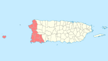
National Register entries listed below are found in the highlighted 12 municipalities of Puerto Rico.
This is a list of properties and districts in the western municipalities of Puerto Rico that are listed on the National Register of Historic Places (Spanish: Registro Nacional de Lugares Históricos). It includes places along the western coast, and on islands, and on the western slope of Puerto Rico's Cordillera Central.
The area covered spans 12 municipalities: Moca, Aguadilla, Aguada, Rincón, Añasco, Mayagüez, Hormigueros, San Germán, Sábana Grande, Guánica, Lajas and Cabo Rojo.
Names of places given are as they appear in the National Register, reflecting name as given in NRHP application at the date of listing. Note, the National Register name system does not accommodate Spanish á, ñ and other letters.
See also:
- National Register of Historic Places listings in southern Puerto Rico
- National Register of Historic Places listings in northern Puerto Rico
- National Register of Historic Places listings in eastern Puerto Rico
- National Register of Historic Places listings in central Puerto Rico
- National Register of Historic Places listings in San Juan, Puerto Rico
- This National Park Service list is complete through NPS recent listings posted December 2, 2016.[1]
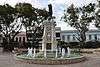
Aguada
| [2] | Name on the Register | Image | Date listed[3] | Location | Barrio | Description |
|---|---|---|---|---|---|---|
| 1 | Puente de Coloso |  |
(#10001102) |
Highway 418, km 0.5 18°23′57″N 67°09′22″W / 18.399083°N 67.156145°W |
Guanábano and Espinar | Historic Bridges of Puerto Rico MPS |
Aguadilla
| [2] | Name on the Register | Image | Date listed[3] | Location | Barrio | Description |
|---|---|---|---|---|---|---|
| 1 | Cardona Residence | 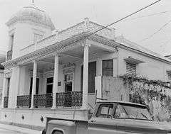 |
(#85000040) |
55 Ramón E. Betances Street 18°25′45″N 67°09′17″W / 18.429120°N 67.154772°W |
Aguadilla Pueblo | |
| 2 | Casa de Piedra | Upload image | (#86000704) |
14 Progreso Street 18°25′18″N 67°09′16″W / 18.421666°N 67.154353°W |
Aguadilla Pueblo | A Spanish colonial house, also known as Amparo Roldán House |
| 3 | Church San Carlos Borromeo of Aguadilla | 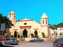 |
(#84003124) |
José de Diego Street, Town Plaza 18°25′47″N 67°09′13″W / 18.429683°N 67.153638°W |
Aguadilla Pueblo | |
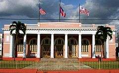
| 4 | District Courthouse |  |
(#85000041) |
Progreso Street 18°25′32″N 67°09′16″W / 18.425514°N 67.154501°W |
Aguadilla Pueblo | |
| 5 | Faro de Punta Borinquen | 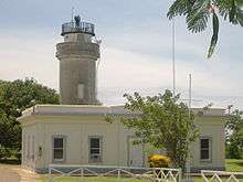 |
(#81000559) |
Off Highway 107 18°29′50″N 67°08′55″W / 18.497226°N 67.148712°W |
Borinquen | |
| 6 | Fuerte de la Concepción[lower-alpha 1] | Upload image | (#86000703) |
Agustín Stahl Street 18°26′11″N 67°09′21″W / 18.436429°N 67.155931°W |
Aguadilla Pueblo | [4] |
| 7 | Old Urban Cemetery | 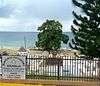 |
(#85000042) |
At the foot of Cuesta Vieja 18°26′16″N 67°09′22″W / 18.437842°N 67.156199°W |
Aguadilla Pueblo | |
| 8 | El Parterre – Ojo De Agua | 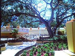 |
(#86000781) |
Bounded by Muñoz Rivera, Gonzalo Firpo, José de Diego, and Mangó Streets 18°25′55″N 67°09′15″W / 18.432083°N 67.154279°W |
Aguadilla Pueblo | |
| 9 | Residence Lopez[lower-alpha 2] |  |
(#85000043) |
67 Progreso Street 18°25′31″N 67°09′15″W / 18.425249°N 67.154159°W |
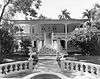
Aguadilla Pueblo | Built in 1914, this one-story, Neoclassical house is architecturally significant as a typical urban residence for a well-to-do Puerto Rican family in the early 20th century, and as one of the most important remaining works by architect Manuel Gómez Tejera.[7] |
Former listings
| [2] | Name on the Register | Image | Date listed | Date removed | Location | City or town | Summary |
|---|---|---|---|---|---|---|---|
| 1 | Silva-Benejan House | Upload image | (#87000725) | 15 Muñoz Rivera Street |
Aguadilla |
Añasco
| [2] | Name on the Register | Image | Date listed[3] | Location | Barrio | Description |
|---|---|---|---|---|---|---|
| 1 | Puente de Añasco | 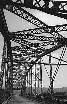 |
(#11000018) |
Highway 2, km 146.1 18°16′21″N 67°09′42″W / 18.272599°N 67.161676°W |
Añasco Arriba and Sabanetas[lower-alpha 3] |
Cabo Rojo
| [2] | Name on the Register | Image | Date listed[3] | Location | Barrio | Description |
|---|---|---|---|---|---|---|
| 1 | Punta Ostiones | Upload image | (#04000908) |
Address restricted[lower-alpha 4][9] |
Miradero | |
| 2 | Faro de los Morrillos de Cabo Rojo | 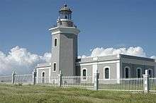 |
(#81000685) |
South of Pole Ojea on Cabo Rojo 17°56′01″N 67°11′32″W / 17.933667°N 67.192194°W |
Boquerón and Llanos Costa | |
| 3 | Silva Bridge | Upload image | (#95000834) |
Highway 114, km 4 18°08′21″N 67°08′45″W / 18.139281°N 67.145699°W |
Guanajibo and Guanajibo[lower-alpha 5] | Pratt pony truss bridge from 1897 |
Guánica
| [2] | Name on the Register | Image | Date listed[3] | Location | Barrio | Description |
|---|---|---|---|---|---|---|
| 1 | Faro de Guanica[lower-alpha 6] | 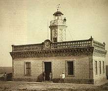 |
(#77001549) |
Highway 333 17°57′03″N 66°54′11″W / 17.950866°N 66.903166°W |
Carenero | This disused and ruined lighthouse was built by Spanish authorities in 1893 in a style reminiscent of plantation great houses. It marked the entrance to Guánica Bay, the most important harbor on the southern side of the island from early colonial times through the Spanish–American War in 1898.[10] |
| 2 | James Garfield Graded School | Upload image | (#15000275) |
65 de Infantería Street 17°58′23″N 66°54′31″W / 17.972925°N 66.908528°W |
Guánica Pueblo | |
| 3 | Hacienda Santa Rita | 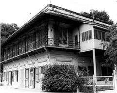 |
(#84003147) |
Highway 116R, km 32.7 18°00′27″N 66°53′03″W / 18.007462°N 66.884302°W |
Susúa Baja | |
| 4 | Yauco Battle Site | 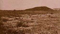 |
(#00001383) |
Roughly bounded by Hacienda Santa Rita, Highways 389, 116R, 116, Loco River, and Seboruco Scarp 18°00′03″N 66°53′16″W / 18.000907°N 66.887886°W |
Susúa Baja | Site of the Battle of Yauco in 1898, in the Spanish–American War. See Puerto Rico Campaign. The Battle field was located at the time in Yauco, however the site became part of modern day Guanica after the founding of the municipality. |
Hormigueros
| [2] | Name on the Register | Image | Date listed[3] | Location | Barrio | Description |
|---|---|---|---|---|---|---|
| 1 | Casa Márquez | Upload image | (#15000311) |
8 Segundo Ruiz Belvis Street at Mateo Fajardo Street 18°08′19″N 67°07′41″W / 18.138524°N 67.127952°W |
Hormigueros Pueblo | |
| 2 | Santuario de la Monserrate de Hormigueros and Casa de Peregrinos | 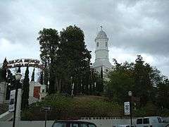 |
(#75002134) |
1 Peregrinos Street and Highway 344 18°08′26″N 67°07′38″W / 18.140676°N 67.127164°W |
Hormigueros Pueblo | A church |
| 3 | Silva Bridge | Upload image | (#95000834) |
Highway 114, km 4 18°08′21″N 67°08′45″W / 18.139281°N 67.145699°W |
Guanajibo and Guanajibo[lower-alpha 5] | Pratt pony truss bridge from 1897 |
| 4 | Torrens Bridge[lower-alpha 7] | Upload image | (#00000423) |
Highway 319, km 1.5 18°07′36″N 67°07′24″W / 18.126711°N 67.123249°W |
Hormigueros and Benavente | This 1878 beam bridge with lattice girders and transverse joists has an engineering design unique in the United States. Built to support local economic development, it was later captured by the U.S. Army in 1898 as part of Battle of Hormigueros during the Spanish–American War.[12] |
Lajas
| [2] | Name on the Register | Image | Date listed[3] | Location | Barrio | Description |
|---|---|---|---|---|---|---|
| 1 | Luis Muñoz Rivera School | Upload image | (#12001076) |
Junction of 65 de Infantería and M. Dávila Streets 18°02′52″N 67°03′33″W / 18.047656°N 67.059094°W |
Lajas Pueblo |
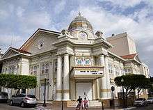
Mayagüez


Former listings
| [2] | Name on the Register | Image | Date listed | Date removed | Location | City or town | Summary |
|---|---|---|---|---|---|---|---|
| 1 | Antiqua Residencia de la Familia Nadal | Upload image | (#86003505) | 13 Dr. Barbosa S |
Mayagüez | ||
| 2 | Baldomero Baunin Residence | Upload image | (#88000687) | Calle Ramos Antonini No. 62 |
Mayagüez |
Moca
| [2] | Name on the Register | Image | Date listed[3] | Location | Barrio | Description |
|---|---|---|---|---|---|---|
| 1 | Hacienda Iruena Manor House | 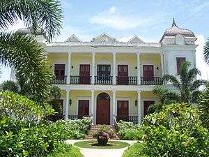 |
(#87000735) |
Highway 2, km 115.7 18°27′11″N 67°03′41″W / 18.452958°N 67.061461°W |
Aceitunas | Renaissance/French Chateau style building from 1893. |
Rincón
| [2] | Name on the Register | Image | Date listed[3] | Location | Barrio | Description |
|---|---|---|---|---|---|---|
| 1 | Boiling Nuclear Superheater (BONUS) Reactor Facility | .png) |
(#07001194) |
End of Branch 4413, Highway 413 18°21′55″N 67°16′07″W / 18.365178°N 67.268657°W |
Puntas | |
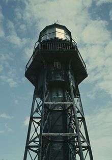
| 2 | Faro de Punta Higuero | 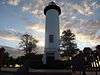 |
(#81000560) |
Branch 4413, Highway 413 18°21′43″N 67°16′15″W / 18.361977°N 67.270806°W |
Puntas |
Sabana Grande
San Germán
| [2] | Name on the Register | Image | Date listed[3] | Location | Barrio | Description |
|---|---|---|---|---|---|---|
| 1 | Jaime Acosta y Fores Residence[lower-alpha 18] | Upload image | (#90000767) |
70 Dr. Santiago Veve Street 18°04′54″N 67°02′25″W / 18.081648°N 67.040234°W |
San Germán Pueblo | Vernacular Criollo house built in 1917[34] |
| 2 | Alcantarilla Pluvial sobre la Quebrada Manzanares | 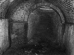 |
(#90000552) |
Extending from approximately the junction of Ferrocarril and Esperanza Streets to approximately the junction of Javilla and Ensanche Streets[lower-alpha 19] 18°04′54″N 67°02′33″W / 18.081531°N 67.042515°W |
San Germán Pueblo | Built in 1835 |
| 3 | Casa de los Ponce de Leon[lower-alpha 20] | Upload image | (#83002295) |
13 Dr. Santiago Veve Street 18°04′56″N 67°02′42″W / 18.082168°N 67.045126°W |
San Germán Pueblo | [36] |
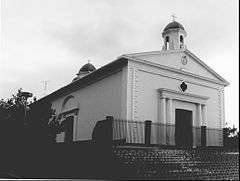
| 4 | Church San Germán Auxerre of San Germán | 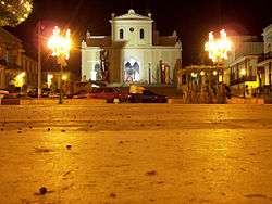 |
(#84000461) |
De la Cruz Street 18°04′57″N 67°02′38″W / 18.082372°N 67.043970°W |
San Germán Pueblo | Church built in 1688 |
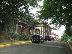
| 5 | Convento de Porta Coeli | .jpg) |
(#76002252) |
Plaza Porta Coeli 18°04′55″N 67°02′28″W / 18.082002°N 67.041002°W |
San Germán Pueblo | |
| 6 | Hacienda Buena Union[lower-alpha 21] | Upload image | (#83002296) |
Highway 362, km 3.0[40][41] 18°05′19″N 67°00′49″W / 18.088533°N 67.013620°W |
Guamá | [38] |
| 7 | Observation Tower | Upload image | (#16000236) |
Highway 120, km 14 18°08′40″N 66°58′48″W / 18.144327°N 66.979924°W |
Caín Alto | |
| 8 | San Germán Historic District |  |
(#94000084) |
Roughly bounded by Luna, Estrella, Concepción, Javilla, and Ferrocarril Streets 18°04′55″N 67°02′38″W / 18.082066°N 67.043789°W |
San Germán Pueblo[lower-alpha 22] | Historic district of colonial and other architecture dating to 1606 |
See also
- National Register of Historic Places listings in Puerto Rico
- Historic preservation
- History of Puerto Rico
Notes
- ↑ Sources authoritative with regard to National Register listing parameters give different forms of the fort's name, including Fuerte de la Concepción from the fort's nomination form,[4] Fuerte de la Concepcion from the official weekly announcement of National Register actions,[5] and Fuerte de la Conception from the comprehensive National Register database.[6] This article adopts the first of these, Fuerte de la Concepción, because it offers the most proper Spanish orthography.
- ↑ The name of the Residence Lopez is presented here using word order and without the accent on "López" in conformance with the usage in the house's National Register nomination form[7] and announcement of listing.[8]
- 1 2 The Puente de Añasco spans the boundary between Añasco (Barrio Añasco Arriba) and Mayagüez (Barrio Sabanetas) municipalities.
- ↑ Federal and state laws and practices restrict general public access to information regarding the specific location of sensitive archeological sites in many instances. The main reasons for such restrictions include the potential for looting, vandalism, or trampling.
- 1 2 The Silva Bridge spans the boundary between Hormigueros (Barrio Guanajibo) and Cabo Rojo (Barrio Guanajibo) municipalities.
- ↑ The name of the Faro de Guanica is presented here without the accent on "Guánica" in conformance with the usage in the light's National Register nomination form[10] and Federal Register announcement of listing.[11]
- ↑ The name of the Torrens is presented here without the accent on "Torréns" in conformance with the usage in the bridge's National Register nomination form[12] and announcement of listing.[13]
- ↑ The name of the Casa Consistorial De Mayaguez is presented here with a capital D and without the diaresis on "Mayagüez" in conformance with the usage in the building's National Register nomination form[14] and announcement of listing.[15]
- ↑ The name of the Edificio Jose de Diego is presented here without the accent on "José" in conformance with the usage in the building's National Register nomination form[16] and Federal Register announcement of listing.[11]</ref>
c
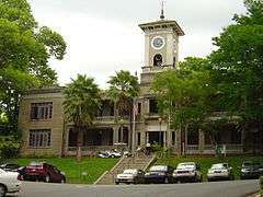
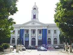
n November 18, 1977 l Register of H University of Puerto Rico at Mayagüez campus
(#77001553)
18°12′33″N 67°08′29″W / 18.209150°N 67.141522°W Mayagüez Pueblo Pueblo |county=[ Central administration building of the University of Puerto Rico at Mayagüez, from 1913<ref name='EdJDNom'>Tarr, A. (1977), National Register of Historic Places Inventory — Nomination Form: Edificio Jose de Diego (PDF), retrieved January 27, 2016. - ↑ The name of the Gomez Residencia is presented here using word order that conforms to the usage in the house's National Register announcement of listing[17] and subsequent database entries.[18][19] The accent is omitted from "Gómez" in conformance with both of those sources as well as the house's National Register nomination form.[20]</ref>
Upload image
o
June 15, 1988 roperty Submiss 60 Méndez Vigo Street
(#88000656)
18°12′09″N 67°08′37″W / 18.202512°N 67.143482°W Mayagüez Pueblo guadilla]] |date Building from 1933 designed by architect Francisco Porrata Doria<ref name='GómezNom'>Del Campo, Félix Julián; Ortiz, Jorge (December 10, 1987), National Register of Historic Places Registration Form: Residencia Gomez (PDF), retrieved November 17, 2015. - ↑ The name of La Casa Solariega de Jose De Diego is presented here with a capital D in the second "de" and without the accent on "José" in conformance with the usage in the house's National Register nomination form[21] and announcement of listing.[22]
- ↑ The name of the Nazario Rivera Residencia is presented here using word order (name preceding "Residencia") that conforms to the usage in the house's National Register announcement of listing[23] and subsequent database entries.[18][24]
- ↑ The name of the Plaza Publica is presented here without the accent on "Pública" in conformance with the usage in the plaza's National Register nomination form[25] and announcement of listing.[15]</ref>
n December 3, 1985 southern Puerto Candelaria Street
(#85003085)
18°12′04″N 67°08′21″W / 18.201108°N 67.139103°W Mayagüez Pueblo =55 Ramón E. Bet From 1760<ref name='PlazPubNom'>Colegio de Arquitectos de Puerto Rico (September 1984), National Register of Historic Places Inventory — Nomination Form: Plaza Publica (PDF), retrieved January 26, 2016. - ↑ The name of the Ramírez Fuentes Residencia is presented here using word order (name preceding "Residencia") that conforms to the usage in the house's National Register announcement of listing[26] and subsequent database entries.[18][27] Also note that while the announcement and databases treat Ramirez as a forename and Fuentes as a surname and omit the accent from Ramírez, the house's National Register nomination form treats Ramírez Fuentes, including the accent, as a compound surname (section 9 mentions "Mrs. Mirta Ramírez de Fuentes");[28] for these purposes, this article adopts the nomination's usage.</ref>
e Upload image
R
July 12, 1988 |city=Aguadilla 117 Méndez Vigo Street
(#88000965)
18°12′06″N 67°08′12″W / 18.201699°N 67.136683°W Mayagüez Pueblo Rico) |name=Dis Bungalow/Craftsman building from 1925, designed by Pascasio Fajardo<ref name='RamFuNom'>Rigau, Jorge; Bérmudez, Manuel; Del Cueto, Beatriz (December 1987), National Register of Historic Places Registration Form: Residencia Ramírez Fuentes (PDF), retrieved January 29, 2016. - ↑ The name of the Residencia Ramirez De Arellano en Guanajibo is presented here with a capital D and without the accent on "Ramírez" in conformance with the usage in the house's National Register nomination form[29] and announcement of listing.[30]
- ↑ The name of the Teatro Yaguez is presented here without the diaresis on "Yagüez" in conformance with the usage in the theater's National Register nomination form[31] and announcement of listing.[15]</ref>
e
N December 2, 1985 Places listing Junction of Candelaria and Basora Streets
(#85003086)
18°12′04″N 67°08′25″W / 18.201219°N 67.140208°W Mayagüez Pueblo Ramón E. Betance From 1909, designed by Sabas Honore et al.<ref name='TheatYaNom'>Cardalda, Cristina; Torres, Olga; Rigau, Jorge (September 1984), National Register of Historic Places Inventory — Nomination Form: Teatro Yaguez (PDF), retrieved January 26, 2016. - ↑ The name of the Berta Sepulveda House is presented here without the accent on "Sepúlveda" in conformance with the usage in the house's National Register nomination form[32] and announcement of listing.[33]
- ↑ The name of the Jaime Acosta y Fores Residence is presented here without the accent on "Forés" in conformance with the usage in the house's National Register nomination form[34] and announcement of listing.[35]
- ↑ The Alcantarilla Pluvial sobre la Quebrada Manzanares is a linear resource; the coordinates given represent the approximate midpoint of the line.
- ↑ The name of the Casa de los Ponce de Leon is presented here without the accent on "León" in conformance with the usage in the house's National Register nomination form[36] and announcement of listing.[37]
- ↑ The name of Hacienda Buena Union is presented here without the accent on "Unión" in conformance with the usage in the hacienda's National Register nomination form[38] and announcement of listing.[39]
- ↑ A minor portion of the San Germán Historic District extends into Barrio Sabana Grande Abajo.
References
- ↑ "National Register of Historic Places: Weekly List Actions". National Park Service, United States Department of the Interior. Retrieved on December 2, 2016.
- 1 2 3 4 5 6 7 8 9 10 11 12 13 14 Numbers represent an ordering by significant words. Various colorings, defined here, differentiate National Historic Landmarks and historic districts from other NRHP buildings, structures, sites or objects.
- 1 2 3 4 5 6 7 8 9 10 11 12 The eight-digit number below each date is the number assigned to each location in the National Register Information System database, which can be viewed by clicking the number.
- 1 2 Del Campo, Félix Julián; Acevedo, Joaquín (January 1986), National Register of Historic Places Inventory — Nomination Form: Fuerte de la Concepción (Conception Fort) (PDF), retrieved January 18, 2016.
- ↑ National Park Service (April 18, 1986), Weekly announcement of National Register of Historic Places actions (PDF), p. 48, retrieved January 18, 2016.
- ↑ National Park Service (n.d.), "Fuerte de la Conception", NPS Focus, retrieved February 25, 2016.
- 1 2 Bourdony, José R. (August 30, 1984), National Register of Historic Places Inventory — Nomination Form: Residence Lopez (PDF), retrieved February 4, 2016.
- ↑ National Park Service (January 11, 1985), Weekly announcement of National Register of Historic Places actions (PDF), p. 4, retrieved February 4, 2016.
- ↑ Knoerl, John; Miller, Diane; Shrimpton, Rebecca H. (1990), Guidelines for Restricting Information about Historic and Prehistoric Resources, National Register Bulletin (29), National Park Service, U.S. Department of the Interior, OCLC 20706997.
- 1 2 Tarr, J. A. (August 1976), National Register of Historic Places Inventory — Nomination Form: Faro de Guanica (Lighthouse) (PDF), retrieved January 18, 2016.
- 1 2 "Department of the Interior, Heritage Conservation and Recreation Service: National Register of Historic Places; Annual Listing of Historic Properties", 44 FR 7416 (February 6, 1979), at 7581.
- 1 2 Albino Plugues, Edwin; Marull, José E.; Tosteson, Hugh (January 31, 2000), National Register of Historic Places Registration Form: Torrens Bridge (PDF), retrieved February 3, 2016.
- ↑ National Park Service (February 19, 2000), Weekly List of Actions Taken on Properties: 5/08/00 through 5/12/00, archived from the original on April 3, 2015, retrieved February 3, 2016.
- 1 2 Bermúdez, Manuel; Del Cueto de Pantel, Beatriz (September 1984), National Register of Historic Places Inventory — Nomination Form: Casa Consistorial De Mayaguez (PDF), retrieved January 26, 2016.
- 1 2 3 National Park Service (December 13, 1985), Weekly announcement of National Register of Historic Places actions (PDF), p. 179–180, retrieved January 26, 2016.
- ↑
- ↑ National Park Service (June 24, 1988), Weekly announcement of National Register of Historic Places actions (PDF), p. 72, retrieved November 17, 2015.
- 1 2 3 National Park Service (March 13, 2009). "National Register Information System". National Register of Historic Places. National Park Service.
- ↑ National Park Service (n.d.), "Gomez Residencia", NPS Focus, retrieved November 17, 2015.
- ↑
- 1 2 Rigau, Jorge (September 1985), National Register of Historic Places Inventory — Nomination Form: La Casa Solariega de Jose De Diego (PDF), retrieved January 27, 2016.
- ↑ National Park Service (April 11, 1986), Weekly announcement of National Register of Historic Places actions (PDF), p. 43, retrieved January 26, 2016.
- ↑ National Park Service (September 23, 1988), Weekly List of Listed Properties: 9/12/88 through 9/16/88 (PDF), p. 144, retrieved January 28, 2016.
- ↑ National Park Service (n.d.), "Rivera, Nazario, Residencia", NPS Focus, retrieved January 28, 2016.
- ↑
- ↑ National Park Service (July 22, 1988), Weekly List of Listed Properties: 7/11/88 through 7/15/88 (PDF), p. 95, retrieved January 29, 2016.
- ↑ National Park Service (n.d.), "Fuentes, Ramirez, Residencia", NPS Focus, retrieved January 29, 2016.
- ↑
- 1 2 Ramírez, José; Del Cueto de Pantel, Beatriz (September 1984), National Register of Historic Places Inventory — Nomination Form: Residencia Ramirez De Arellano en Guanajibo (PDF), retrieved January 27, 2016.
- ↑ National Park Service (February 13, 1987), Weekly announcement of National Register of Historic Places actions (PDF), p. 17, retrieved January 27, 2016.
- ↑
- 1 2 Marull, José E.; Crespo, Rafael (January 28, 1994), National Register of Historic Places Registration Form: Berta Sepulveda Residence (PDF), retrieved February 3, 2016.
- ↑ National Park Service (June 24, 1994), Weekly List of Actions Taken on Properties: 6/13/94 through 6/17/94 (PDF), p. 34, retrieved February 3, 2016.
- 1 2 Santiago Cazull, Héctor F. (October 19, 1989), National Register of Historic Places Registration Form: Jaime Acosta y Fores Residence (PDF), retrieved February 3, 2016.
- ↑ National Park Service (June 1, 1990), Weekly List of Listed Properties: 5/21/90 through 5/25/90 (PDF), p. 52, retrieved February 3, 2016.
- 1 2 Tió, Aurelio (January 4, 1983), National Register of Historic Places Inventory — Nomination Form: Casa de los Ponce de Leon (PDF), retrieved February 2, 2016.
- ↑ National Park Service (March 15, 1983), Weekly announcement of National Register of Historic Places actions (PDF), p. 51, retrieved February 2, 2016.
- 1 2 Muratti Martínez, Víctor; Pumarada O'Neill, Luis (February 24, 1983), National Register of Historic Places Inventory — Nomination Form: Hacienda Buena Union (redacted PDF), retrieved February 3, 2016.
- ↑ National Park Service (August 30, 1983), Weekly announcement of National Register of Historic Places actions (PDF), p. 132, retrieved February 3, 2016.
- ↑ Oficina Estatal de Conservación Histórica (April 1, 2014), Hacienda Buena Unión – Trapiche del Guamá – Hacienda Acosta (PDF) (summary sheet), retrieved February 3, 2016.
- ↑ Oficina Estatal de Conservación Histórica (n.d.), Puerto Rico: Registro Nacional de Lugares Históricos [Puerto Rico: National Register of Historic Places] (online GIS), retrieved February 3, 2016.
External links
- Puerto Rico State Historic Preservation Office, National Register of Historic Places site
- National Park Service, National Register of Historic Places site
 Media related to National Register of Historic Places in Puerto Rico at Wikimedia Commons
This article is issued from Wikipedia - version of the 10/5/2016. The text is available under the Creative Commons Attribution/Share Alike but additional terms may apply for the media files.