| [3] |
Name on the Register |
Image |
Date listed[4] |
Location |
City or town |
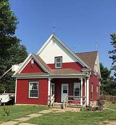
Description |
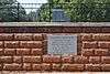
|---|
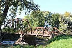
| 1 |
Babylon Bend Bridge |
Upload image |
000000001980-10-29-0000October 29, 1980
(#80001355) |
Illinois Route 123
40°35′06″N 90°20′53″W / 40.585°N 90.348056°W / 40.585; -90.348056 (Babylon Bend Bridge) |
Ellisville |
|
| 2 |
Bernadotte Bridge |
|
000000001980-10-29-0000October 29, 1980
(#80001360) |
Illinois Route 2
40°24′13″N 90°19′15″W / 40.403611°N 90.320833°W / 40.403611; -90.320833 (Bernadotte Bridge) |
Smithfield |
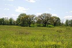
|
| 3 |
Buckeye Bridge |
|
000000001980-10-29-0000October 29, 1980
(#80001361) |
Spans Spoon River
40°31′54″N 90°18′40″W / 40.531667°N 90.311111°W / 40.531667; -90.311111 (Buckeye Bridge) |
Smithfield |
|
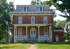
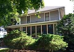
| 4 |
Carithers Store Building |
|
000000001987-08-03-0000August 3, 1987
(#87001262) |
Table Grove village square, west of U.S. Route 136
40°21′58″N 90°25′32″W / 40.366096°N 90.4255°W / 40.366096; -90.4255 (Carithers Store Building) |
Table Grove |
|
| 5 |
Chicago, Burlington and Quincy Railroad Station |
|
000000001993-08-31-0000August 31, 1993
(#93000842) |
Along 4th Ave. between E. Elm St. and E. Chestnut St.
40°33′23″N 90°01′44″W / 40.556389°N 90.028889°W / 40.556389; -90.028889 (Chicago, Burlington and Quincy Railroad Station) |
Canton |
|
| 6 |
Edith Chipman House |
|
000000001996-11-07-0000November 7, 1996
(#96001290) |
201 W. 3rd St.
40°17′43″N 90°25′44″W / 40.295278°N 90.428889°W / 40.295278; -90.428889 (Edith Chipman House) |
Vermont |
|
| 7 |
Dickson Mounds |
|
000000001972-05-05-0000May 5, 1972
(#72000457) |
Off County Road 4
40°21′03″N 90°06′31″W / 40.350833°N 90.108611°W / 40.350833; -90.108611 (Dickson Mounds) |
Lewistown |
|
| 8 |
Robert Dilworth House |
Upload image |
000000001993-11-12-0000November 12, 1993
(#93001236) |
606 E. 5th St.
40°17′39″N 90°25′11″W / 40.294167°N 90.419722°W / 40.294167; -90.419722 (Robert Dilworth House) |
Vermont |
|
| 9 |
Duncan Mills Bridge |
Upload image |
000000001980-10-29-0000October 29, 1980
(#80001356) |
West of Havana
40°20′28″N 90°11′27″W / 40.341111°N 90.190833°W / 40.341111; -90.190833 (Duncan Mills Bridge) |
Lewistown |
|
| 10 |
William Franklin and Rebecca Durell House |
|
000000001996-11-07-0000November 7, 1996
(#96001292) |
408 W. 5th St.
40°17′38″N 90°25′55″W / 40.293889°N 90.431944°W / 40.293889; -90.431944 (William Franklin and Rebecca Durell House) |
Vermont |
|
| 11 |
Duvall-Ash Farmstead |
Upload image |
000000001993-11-12-0000November 12, 1993
(#93001237) |
Off Illinois Route 9, 1 mile east and 1.2 miles north of its junction with Illinois Route 97
40°34′40″N 90°08′23″W / 40.577778°N 90.139722°W / 40.577778; -90.139722 (Duvall-Ash Farmstead) |
Fiatt |
|
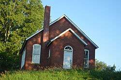
| 12 |
East Waterford School |
|
000000002009-11-10-0000November 10, 2009
(#09000897) |
Junction of North Dickson Mounds Rd. and East Prairie Rd.
40°20′59″N 90°06′55″W / 40.349861°N 90.115278°W / 40.349861; -90.115278 (East Waterford School) |
Lewistown |
|
| 13 |
Edward Hamer House |
|
000000001996-11-07-0000November 7, 1996
(#96001293) |
200 W. 2nd St.
40°17′48″N 90°25′45″W / 40.296667°N 90.429167°W / 40.296667; -90.429167 (Edward Hamer House) |
Vermont |
|
| 14 |
Patterson Hamer House |
|
000000001996-11-07-0000November 7, 1996
(#96001287) |
405 W. 5th St.
40°17′36″N 90°25′52″W / 40.293333°N 90.431111°W / 40.293333; -90.431111 (Patterson Hamer House) |
Vermont |
|
| 15 |
William Hoopes House |
Upload image |
000000001996-11-07-0000November 7, 1996
(#96001285) |
204 N. Liberty St.
40°17′45″N 90°25′44″W / 40.295833°N 90.428889°W / 40.295833; -90.428889 (William Hoopes House) |
Vermont |
|
| 16 |
Lucinda Hunter House |
|
000000001996-11-07-0000November 7, 1996
(#96001286) |
101 E. 8th St.
40°17′26″N 90°25′38″W / 40.290556°N 90.427222°W / 40.290556; -90.427222 (Lucinda Hunter House) |
Vermont |
|
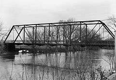
| 17 |
Indian Ford Bridge |
|
000000001980-10-29-0000October 29, 1980
(#80001357) |
Illinois Route 20
40°41′25″N 90°17′24″W / 40.690278°N 90.29°W / 40.690278; -90.29 (Indian Ford Bridge) |
London Mills |
Now demolished.
|
| 18 |
Larson Site |
|
000000001978-11-21-0000November 21, 1978
(#78001145) |
Waterford Rd. north of the Waterford Cemetery[5]
40°20′36″N 90°07′52″W / 40.34333°N 90.13111°W / 40.34333; -90.13111 (Larson Site) |
Lewistown |
|
| 19 |
London Mills Bridge |
|
000000001980-10-29-0000October 29, 1980
(#80001358) |
Illinois Route 39
40°42′36″N 90°16′00″W / 40.71°N 90.266667°W / 40.71; -90.266667 (London Mills Bridge) |
London Mills |
Now demolished.
|
| 20 |
Charles Emmor McCormick House |
|
000000001996-11-07-0000November 7, 1996
(#96001284) |
712 W. 3rd St.
40°17′45″N 90°26′05″W / 40.295833°N 90.434722°W / 40.295833; -90.434722 (Charles Emmor McCormick House) |
Vermont |
|
| 21 |
Joab Mershon House |
|
000000001996-11-07-0000November 7, 1996
(#96001294) |
507 W. 5th St.
40°17′36″N 90°25′59″W / 40.293333°N 90.433056°W / 40.293333; -90.433056 (Joab Mershon House) |
Vermont |
|
| 22 |
Daniel O'Connell House |
|
000000001996-11-07-0000November 7, 1996
(#96001288) |
115 N. Union St.
40°17′43″N 90°25′34″W / 40.295278°N 90.426111°W / 40.295278; -90.426111 (Daniel O'Connell House) |
Vermont |
|
| 23 |
Oak Hill Cemetery |
|
000000001995-11-13-0000November 13, 1995
(#95001240) |
1000 block of N. Main St. (Illinois Routes 97 and 100)
40°24′08″N 90°09′24″W / 40.402222°N 90.156667°W / 40.402222; -90.156667 (Oak Hill Cemetery) |
Lewistown |
|
| 24 |
Odd Fellows Opera Block |
Upload image |
000000001996-08-08-0000August 8, 1996
(#96000876) |
Southwestern corner of the junction of Main and Mechanic Sts.
40°37′36″N 90°18′16″W / 40.626667°N 90.304444°W / 40.626667; -90.304444 (Odd Fellows Opera Block) |
Ellisville |
|
| 25 |
Ogden-Fettie Site |
|
000000001972-07-31-0000July 31, 1972
(#72000458) |
South of Lewistown
40°20′27″N 90°07′06″W / 40.340833°N 90.118333°W / 40.340833; -90.118333 (Ogden-Fettie Site) |
Lewistown |
|
| 26 |
Orendorf Site |
Upload image |
000000001977-09-13-0000September 13, 1977
(#77000484) |
Western side of U.S. Route 24 near the northern end of the Duck Creek Cooling Pond[6]
40°29′15″N 89°57′06″W / 40.48750°N 89.95166°W / 40.48750; -89.95166 (Orendorf Site) |
Canton |
|
| 27 |
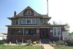
Ulysses G. Orendorff House |
|
000000001971-12-09-0000December 9, 1971
(#71000292) |
345 W. Elm St.
40°33′25″N 90°02′33″W / 40.556944°N 90.0425°W / 40.556944; -90.0425 (Ulysses G. Orendorff House) |
Canton |
|
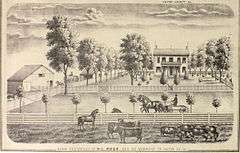
| 28 |
Henry H. Page House |
|
000000001996-11-07-0000November 7, 1996
(#96001289) |
221 N. Union St.
40°17′46″N 90°25′34″W / 40.296111°N 90.426111°W / 40.296111; -90.426111 (Henry H. Page House) |
Vermont |
|
| 29 |
Hiram Palmer House |
Upload image |
000000001999-05-20-0000May 20, 1999
(#99000589) |
703 E. Fort St.
40°41′53″N 89°59′38″W / 40.698056°N 89.993889°W / 40.698056; -89.993889 (Hiram Palmer House) |
Farmington |
|
| 30 |
Parlin Library |
|
000000001994-05-06-0000May 6, 1994
(#94000434) |
210 E. Chestnut St.
40°33′24″N 90°01′53″W / 40.556667°N 90.031389°W / 40.556667; -90.031389 (Parlin Library) |
Canton |
|
| 31 |
Harvey Lee Ross House |
|
000000001996-11-07-0000November 7, 1996
(#96001295) |
602 S. Main St.
40°17′20″N 90°25′41″W / 40.288889°N 90.428056°W / 40.288889; -90.428056 (Harvey Lee Ross House) |
Vermont |
|
| 32 |
Seville Bridge |
Upload image |
000000001980-10-29-0000October 29, 1980
(#80001359) |
Spans the Spoon River in Seville
40°28′22″N 90°17′27″W / 40.472778°N 90.290833°W / 40.472778; -90.290833 (Seville Bridge) |
Seville |
|
| 33 |
Sheets Site |
Upload image |
000000001978-12-22-0000December 22, 1978
(#78001146) |
County Road 14, west of Lewistown[7]
40°24′01″N 90°12′40″W / 40.40027°N 90.21111°W / 40.40027; -90.21111 (Sheets Site) |
Lewistown |
|
| 34 |
Sleeth Site |
|
000000001979-05-17-0000May 17, 1979
(#79000837) |
Northeast of the junction of U.S. Route 24 and Pollitt Rd.[8]
40°25′27″N 90°00′00″W / 40.42416°N 90.00000°W / 40.42416; -90.00000 (Sleeth Site) |
Liverpool |
|
| 35 |
Elsworth Snowden House |
|
000000001996-11-07-0000November 7, 1996
(#96001283) |
504 W. 3rd St.
40°17′44″N 90°26′00″W / 40.295556°N 90.433333°W / 40.295556; -90.433333 (Elsworth Snowden House) |
Vermont |
|
| 36 |
South Fulton Churchhouse |
Upload image |
000000001994-10-28-0000October 28, 1994
(#94001264) |
2.2 miles south of the junction of Astoria-Bader Rd. and U.S. Route 24
40°11′45″N 90°21′26″W / 40.195833°N 90.357222°W / 40.195833; -90.357222 (South Fulton Churchhouse) |
Astoria |
|
| 37 |
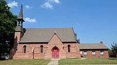
St. James Episcopal Church |
|
000000001974-12-31-0000December 31, 1974
(#74000761) |
Northeastern corner of the junction of MacArthur and Broadway
40°23′56″N 90°09′06″W / 40.398889°N 90.151738°W / 40.398889; -90.151738 (St. James Episcopal Church) |
Lewistown |
|
| 38 |
Stapleford-Hoover-Whitney House |
|
000000001996-11-07-0000November 7, 1996
(#96001291) |
401 N. Main St.
40°17′51″N 90°25′38″W / 40.2975°N 90.427222°W / 40.2975; -90.427222 (Stapleford-Hoover-Whitney House) |
Vermont |
|
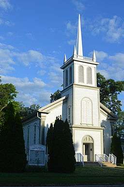
| 39 |
Table Grove Community Church |
|
000000001979-02-09-0000February 9, 1979
(#79003783) |
N. Broadway and W. Liberty Sts.
40°22′00″N 90°25′32″W / 40.366667°N 90.425556°W / 40.366667; -90.425556 (Table Grove Community Church) |
Table Grove |
|
| 40 |
Tampico Mounds |
Upload image |
000000001979-05-14-0000May 14, 1979
(#79000838) |
West of the junction of U.S. Route 24 and County Road 8[9]
40°24′58″N 90°00′56″W / 40.41611°N 90.01555°W / 40.41611; -90.01555 (Tampico Mounds) |
Maples Mill |
|
| 41 |
Tartar's Ferry Bridge |
|
000000001980-10-29-0000October 29, 1980
(#80001363) |
Spans the Spoon River southwest of Smithfield
40°26′47″N 90°21′02″W / 40.446389°N 90.350556°W / 40.446389; -90.350556 (Tartar's Ferry Bridge) |
Smithfield |
|
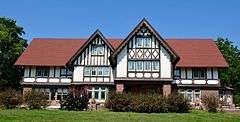
| 42 |
Vermont Historic District |
Upload image |
000000001997-11-24-0000November 24, 1997
(#97001334) |
Roughly bounded by 2nd, Union, 4th, and Liberty Sts.
40°17′42″N 90°25′40″W / 40.295075°N 90.427713°W / 40.295075; -90.427713 (Vermont Historic District) |
Vermont |
|
| 43 |
Vermont Masonic Hall |
Upload image |
000000001988-11-16-0000November 16, 1988
(#88002236) |
N. Main St.
40°17′42″N 90°25′39″W / 40.295°N 90.4275°W / 40.295; -90.4275 (Vermont Masonic Hall) |
Vermont |
|