National Register of Historic Places listings in Evanston, Illinois
This is a list of the 61 National Register of Historic Places listings in Evanston, Illinois.
Current listings
| [1] | Name on the Register[2] | Image | Date listed[3] | Location | City or town | Description |
|---|---|---|---|---|---|---|
| 1 | Andridge Apartments |  |
(#84000927) |
1627-1645 Ridge Ave., 1124-1136 Church St. 42°02′54″N 87°41′19″W / 42.048333°N 87.688611°W |
||
| 2 | Building at 1101-1113 Maple Avenue |  |
(#84000960) |
1101-1113 Maple Ave. 42°02′17″N 87°41′06″W / 42.038056°N 87.685°W |
||
| 3 | Building at 1209-1217 Maple Avenue |  |
(#84000964) |
1209-1217 Maple Ave. 42°02′24″N 87°41′06″W / 42.04°N 87.685°W |
||
| 4 | Building at 1301-1303 Judson Avenue |  |
(#84000968) |
1301-1303 Judson Ave. 42°02′29″N 87°40′36″W / 42.041389°N 87.676667°W |
||
| 5 | Building at 1305-1307 Judson Avenue |  |
(#84000966) |
1305-1307 Judson Ave. 42°02′30″N 87°40′37″W / 42.041667°N 87.676944°W |
||
| 6 | Building at 1316 Maple Avenue |  |
(#84000969) |
1316 Maple Ave. 42°02′31″N 87°41′09″W / 42.041944°N 87.685833°W |
||
| 7 | Building at 1401-1407 Elmwood Avenue |  |
(#84000973) |
1401-1407 Elmwood Ave. 42°02′35″N 87°41′00″W / 42.043056°N 87.683333°W |
||
| 8 | Building at 1505-1509 Oak Avenue |  |
(#84000976) |
1505-1509 Oak Ave. 42°02′43″N 87°41′12″W / 42.045278°N 87.686667°W |
||
| 9 | Building at 1929-1931 Sherman Avenue |  |
(#84000978) |
1929-1931 Sherman Ave. 42°03′12″N 87°40′54″W / 42.053333°N 87.681667°W |
||
| 10 | Building at 2517 Central Street |  |
(#84000980) |
2517 Central St. 42°03′53″N 87°42′31″W / 42.064722°N 87.708611°W |
||
| 11 | Building at 2519 Central Street | 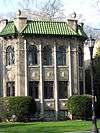 |
(#84000982) |
2519 Central St. 42°03′53″N 87°42′33″W / 42.064722°N 87.709167°W |
||
| 12 | Building at 2523 Central Street | 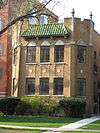 |
(#84000983) |
2523 Central St. 42°03′53″N 87°42′35″W / 42.064722°N 87.709722°W |
||
| 13 | Building at 417-419 Lee Street |  |
(#84000942) |
417-419 Lee St. 42°02′10″N 87°40′39″W / 42.036111°N 87.6775°W |
||
| 14 | Building at 548-606 Michigan Avenue |  |
(#84000945) |
548-606 Michigan Ave. 42°01′43″N 87°40′21″W / 42.028611°N 87.6725°W |
||
| 15 | Building at 813-815 Forest Avenue |  |
(#84000950) |
813-815 Forest Ave. 42°01′58″N 87°40′26″W / 42.032778°N 87.673889°W |
||
| 16 | Building at 923-925 Michigan Avenue | 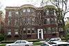 |
(#84000953) |
923-925 Michigan Ave. 42°02′05″N 87°40′23″W / 42.034722°N 87.673056°W |
||
| 17 | Building at 999 Michigan, 200 Lee |  |
(#84000958) |
999 Michigan Ave., 200 Lee St. 42°02′08″N 87°40′24″W / 42.035556°N 87.673333°W |
||
| 18 | Buildings at 1104-1110 Seward |  |
(#86001743) |
1104-1110 Seward 42°01′44″N 87°41′16″W / 42.028889°N 87.687778°W |
||
| 19 | Buildings at 815-817 Brummel and 819-821 Brummel |  |
(#84000952) |
815-817, and 819-821 Brummel St. 42°01′17″N 87°41′04″W / 42.021389°N 87.684444°W |
||
| 20 | Frederick B. Carter, Jr. House | .jpg) |
(#74000758) |
1024 Judson Ave. 42°02′11″N 87°40′37″W / 42.036389°N 87.676944°W |
1910 Prairie School style house, designed by Walter Burley Griffin. | |
| 21 | Castle Tower Apartments |  |
(#84000985) |
2212-2226 Sherman Ave. 42°03′30″N 87°40′56″W / 42.058333°N 87.682222°W |
||
| 22 | Colonnade Court |  |
(#84000987) |
501-507 Main St., 904-908 Hinman Ave. 42°02′06″N 87°40′43″W / 42.035°N 87.678611°W |
||
| 23 | Charles Gates Dawes House | 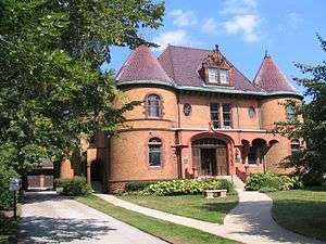 |
(#76000706) |
225 Greenwood St. 42°02′35″N 87°40′25″W / 42.043056°N 87.673611°W |
Home of the Evanston History Center | |
| 24 | George B. Dryden House |  |
(#78001135) |
1314 Ridge Ave. 42°02′30″N 87°41′21″W / 42.041667°N 87.689167°W |
||
| 25 | Evanston Lakeshore Historic District |  |
(#80001353) |
Roughly bounded by Northwestern University, Lake Michigan, Calvary Cemetery, and Chicago Ave. 42°02′15″N 87°40′30″W / 42.0375°N 87.675°W |
||
| 26 | Evanston Ridge Historic District |  |
(#83000309) |
Roughly bounded by Main, Asbury, Ashland, Emerson, Ridge and Maple Ave. 42°02′35″N 87°41′21″W / 42.043056°N 87.689167°W |
||
| 27 | Evanston Towers |  |
(#84000990) |
554-602 Sheridan Sq. 42°01′43″N 87°40′10″W / 42.028611°N 87.669444°W |
||
| 28 | The Forest and Annex |  |
(#84000991) |
901-905 Forest Ave. 42°02′02″N 87°40′27″W / 42.033889°N 87.674167°W |
||
| 29 | Fountain Plaza Apartments |  |
(#84000992) |
830-856 Hinman Ave. 42°02′00″N 87°40′42″W / 42.033333°N 87.678333°W |
||
| 30 | The Greenwood |  |
(#84000993) |
425 Greenwood St. 42°02′35″N 87°40′44″W / 42.043056°N 87.678889°W |
||
| 31 | Grosse Point Light Station |  |
(#76000707) |
2601 Sheridan Rd. 42°03′50″N 87°40′34″W / 42.063889°N 87.676111°W |
||
| 32 | Hillcrest Apartment |  |
(#84000994) |
1509-1515 Hinman Ave. 42°02′43″N 87°40′42″W / 42.045278°N 87.678333°W |
||
| 33 | Hinman Apartments |  |
(#84000995) |
1629-1631 Hinman Ave. 42°02′48″N 87°40′39″W / 42.046667°N 87.6775°W |
||
| 34 | The Homestead |  |
(#05001607) |
1625 Hinman Ave. 42°02′46″N 87°40′39″W / 42.046111°N 87.6775°W |
||
| 35 | The Judson |  |
(#84000998) |
1243-1249 Judson Ave. 42°02′27″N 87°40′35″W / 42.040833°N 87.676389°W |
||
| 36 | Lake Shore Apartments |  |
(#84001000) |
470-498 Sheridan Rd. 42°01′37″N 87°40′07″W / 42.026944°N 87.668611°W |
||
| 37 | Maple Court Apartments |  |
(#84001013) |
1115-1133 Maple Ave. 42°02′20″N 87°41′06″W / 42.038889°N 87.685°W |
||
| 38 | Marywood Academy | .jpg) |
(#06000007) |
2100 Ridge Ave. 42°03′24″N 87°41′14″W / 42.056715°N 87.687190°W |
A former Catholic girls school which is now home to the Evanston Civic Center [4] | |
| 39 | Melwood Apartments |  |
(#84001016) |
1201-1213 Michigan Ave. and 205-207 Hamilton 42°02′22″N 87°40′24″W / 42.039444°N 87.673333°W |
||
| 40 | Michigan-Lee Apartments |  |
(#84001018) |
940-950 Michigan Ave. 42°02′07″N 87°40′26″W / 42.035278°N 87.673889°W |
||
| 41 | Northeast Evanston Historic District |  |
(#99000979) |
Roughly bounded by Emerson St., Sherman Ave., Sheridan Pl., Lake Michigan, Sheridan Rd., and Orrington Ave. 42°03′40″N 87°40′47″W / 42.061111°N 87.679722°W |
||
| 42 | Oak Ridge Apartments |  |
(#84001025) |
1615-1625 Ridge Ave. 42°02′51″N 87°41′19″W / 42.0475°N 87.688611°W |
||
| 43 | Oakton Gables | 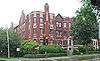 |
(#84001024) |
900-910 Oakton St. and 439-445 Ridge Ave. 42°01′35″N 87°41′07″W / 42.026389°N 87.685278°W |
||
| 44 | Oakton Historic District |  |
(#05000106) |
Roughly bounded by Oakton St., Howard St., Ridge Ave., and Asbury Ave. 42°01′31″N 87°41′15″W / 42.025278°N 87.6875°W |
||
| 45 | Dwight Perkins House | 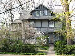 |
(#85001908) |
2319 Lincoln St. 42°03′44″N 87°42′47″W / 42.062222°N 87.713056°W |
||
| 46 | Raymond Park Apartments |  |
(#85003581) |
1501 Hinman and 425 Grove 42°02′41″N 87°40′42″W / 42.044722°N 87.678333°W |
||
| 47 | Ridge Boulevard Apartments |  |
(#84001028) |
843-849 Ridge Ave. and 1014-1020 Main St. 42°02′02″N 87°41′12″W / 42.033889°N 87.686667°W |
||
| 48 | Ridge Grove | 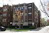 |
(#84001030) |
1112 Grove St. 42°02′43″N 87°41′16″W / 42.045278°N 87.687778°W |
||
| 49 | Ridge Manor |  |
(#84001034) |
1603-1611 Ridge Ave. and 1125 Davis St. 42°02′51″N 87°41′19″W / 42.0475°N 87.688611°W |
||
| 50 | Ridgewood |  |
(#78001136) |
1703-1713 Ridge Ave. 42°02′56″N 87°41′18″W / 42.048889°N 87.688333°W |
||
| 51 | Rookwood Apartments | 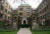 |
(#84001043) |
718-734 Noyes St. 42°03′30″N 87°40′53″W / 42.058333°N 87.681389°W |
||
| 52 | Roycemore School |  |
(#87001256) |
640 Lincoln St. 42°03′41″N 87°40′44″W / 42.061389°N 87.678889°W |
||
| 53 | Shakespeare Garden | .jpg) |
(#88002234) |
Northwestern University campus 42°03′24″N 87°40′34″W / 42.056667°N 87.676111°W |
||
| 54 | Sheridan Square Apartments |  |
(#84001050) |
620-638 Sheridan Sq. 42°01′44″N 87°40′11″W / 42.028889°N 87.669722°W |
||
| 55 | Stoneleigh Manor | 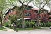 |
(#84001057) |
904-906 Michigan Ave. and 227-229 Main St. 42°02′02″N 87°40′25″W / 42.033889°N 87.673611°W |
||
| 56 | Tudor Manor | 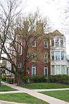 |
(#84001058) |
524 Sheridan Sq. 42°01′39″N 87°40′09″W / 42.0275°N 87.669167°W |
||
| 57 | Edward Kirk Warren House and Garage | 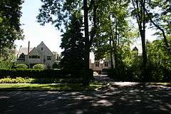 |
(#86000136) |
2829 and 2831 Sheridan Pl. 42°04′10″N 87°40′46″W / 42.069444°N 87.679444°W |
||
| 58 | Westminster |  |
(#84001061) |
632-640 Hinman Ave. 42°01′47″N 87°40′39″W / 42.029722°N 87.6775°W |
||
| 59 | Frances Willard House |  |
(#66000318) |
1730 Chicago Ave. 42°02′54″N 87°40′45″W / 42.048333°N 87.679167°W |
||
| 60 | Woman's Christian Temperance Union Administration Building |  |
(#02000849) |
1730R Chicago Ave. 42°02′56″N 87°40′45″W / 42.048973°N 87.679151°W |
||
| 61 | Woman's Club of Evanston | 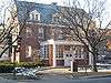 |
(#06001020) |
1702 Chicago Ave. 42°02′53″N 87°40′45″W / 42.048136°N 87.679063°W |
| Wikimedia Commons has media related to National Register of Historic Places in Evanston, Illinois. |
References
- ↑ Numbers represent an ordering by significant words. Various colorings, defined here, differentiate National Historic Landmarks and historic districts from other NRHP buildings, structures, sites or objects.
- ↑ National Park Service (2007-01-23). "National Register Information System". National Register of Historic Places. National Park Service.
- ↑ The eight-digit number below each date is the number assigned to each location in the National Register Information System database, which can be viewed by clicking the number.
- ↑ http://www.cityofevanston.org/government/council/civic.shtml#Marywood Evanston Civic Center History
This article is issued from Wikipedia - version of the 5/26/2016. The text is available under the Creative Commons Attribution/Share Alike but additional terms may apply for the media files.