National Register of Historic Places listings in Converse County, Wyoming

Location of Converse County in Wyoming
This is a list of the National Register of Historic Places listings in Converse County, Wyoming.
This is intended to be a complete list of the properties and districts on the National Register of Historic Places in Converse County, Wyoming, United States. The locations of National Register properties and districts for which the latitude and longitude coordinates are included below, may be seen in a map.[1]
There are 23 properties and districts listed on the National Register in the county.
- This National Park Service list is complete through NPS recent listings posted December 2, 2016.[2]
| Albany - Big Horn - Campbell - Carbon - Converse - Crook - Fremont - Goshen - Hot Springs - Johnson - Laramie - Lincoln - Natrona - Niobrara - Park - Platte - Sheridan - Sublette - Sweetwater - Teton - Uinta - Washakie - Weston |
Current listings
| [3] | Name on the Register | Image | Date listed[4] | Location | City or town | Description |
|---|---|---|---|---|---|---|
| 1 | Antelope Creek Crossing (48CO171 and 48CO165) | Upload image | (#89000816) |
Confluence of Antelope Creek and Spring Draw, east of Ross[5] 43°25′45″N 105°48′28″W / 43.429167°N 105.807778°W |
Ross | |
| 2 | Braehead Ranch | Upload image | (#95001074) |
69 Moss Agate Rd. 42°39′59″N 105°39′34″W / 42.666389°N 105.659444°W |
Douglas | |
| 3 | Christ Episcopal Church and Rectory | 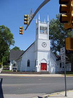 |
(#80004046) |
4th and Center Sts. 42°45′35″N 105°22′54″W / 42.759722°N 105.381667°W |
Douglas | |
| 4 | College Inn Bar |  |
(#79002608) |
103 N. 2nd St. 42°45′36″N 105°23′00″W / 42.76°N 105.383333°W |
Douglas | |
| 5 | Commerce Block |  |
(#04001548) |
4th and Birch Sts. 42°51′40″N 105°52′17″W / 42.861111°N 105.871389°W |
Glenrock | |
| 6 | Dorr Ranch | Upload image | (#14001080) |
Approx. 5 mi. NE. of Woody Creek & Steinle Rds. Coordinates missing |
Bill vicinity | |
| 7 | Douglas City Hall |  |
(#94000167) |
130 S. 3rd St. 42°45′29″N 105°23′02″W / 42.758056°N 105.383889°W |
Douglas | |
| 8 | Fort Fetterman |  |
(#69000187) |
7 miles north of Interstate 25 on Orpha Rd. 42°50′36″N 105°29′07″W / 42.843333°N 105.485278°W |
Orpha | |
| 9 | Fremont, Elkhorn & Missouri Valley Railroad Passenger Depot | |
(#94000741) |
100 Walnut St. 42°45′39″N 105°23′10″W / 42.76094°N 105.38617°W |
Douglas | |
| 10 | Glenrock Buffalo Jump | Upload image | (#69000186) |
Near the center of Section 11, Township 33 North, Range 76 West[6] 42°50′38″N 105°56′00″W / 42.843889°N 105.933333°W |
Glenrock | |
| 11 | Holdup Hollow Segment, Bozeman Trail (48CO165) | Upload image | (#89000818) |
In Holdup Hollow, north of Glenrock[7] 43°05′39″N 105°42′50″W / 43.094167°N 105.713889°W |
Glenrock | |
| 12 | Hotel Higgins |  |
(#83004280) |
416 W. Birch 42°51′40″N 105°52′23″W / 42.861111°N 105.873056°W |
Glenrock | |
| 13 | Hotel LaBonte | 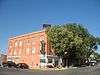 |
(#08001003) |
206 Walnut St. 42°45′40″N 105°23′06″W / 42.761052°N 105.385024°W |
Douglas | |
| 14 | Huxtable Ranch Headquarters District | Upload image | (#10001172) |
1351 Boxelder Rd. 42°40′06″N 105°48′15″W / 42.668333°N 105.804167°W |
Glenrock | Ranches, Farms, and Homesteads in Wyoming, 1860-1960 MPS |
| 15 | Jenne Block |  |
(#97001600) |
301 Center St. 42°45′33″N 105°22′59″W / 42.759167°N 105.383056°W |
Douglas | |
| 16 | La Prele Work Center | Upload image | (#94000272) |
Southwest of Douglas, Medicine Bow National Forest Coordinates missing |
Douglas | |
| 17 | Morton Mansion | 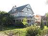 |
(#00001644) |
425 Center St. 42°45′33″N 105°22′51″W / 42.759167°N 105.380833°W |
Douglas | |
| 18 | North Douglas Historic District | 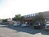 |
(#00001470) |
Roughly bounded by 2nd St., Clay St., 6th St., and Center St. 42°45′45″N 105°22′54″W / 42.7625°N 105.381667°W |
Douglas | |
| 19 | Officer's Club, Douglas Prisoner of War Camp |  |
(#01000965) |
115 S. Riverbend Dr. 42°45′31″N 105°24′22″W / 42.758721°N 105.406029°W |
Douglas | |
| 20 | Ross Flat Segment, Bozeman Trail (48CO165) | Upload image | (#89000811) |
Ends at Ross Flat, northwest of Ross[8] 43°29′26″N 105°49′49″W / 43.490556°N 105.830278°W |
Ross | |
| 21 | Sage Creek Station (48CO104) | Upload image | (#89000812) |
Address Restricted |
Glenrock | |
| 22 | Stinking Water Gulch Segment, Bozeman Trail (48CO165) | Upload image | (#89000817) |
Along Stinking Water Gulch, southeast of Ross[9] 43°19′38″N 105°41′12″W / 43.327222°N 105.686667°W |
Ross | |
| 23 | US Post Office-Douglas Main |  |
(#87000781) |
129 N. 3rd St. 42°45′38″N 105°22′59″W / 42.760556°N 105.383056°W |
Douglas |
See also
| Wikimedia Commons has media related to National Register of Historic Places in Converse County, Wyoming. |
- List of National Historic Landmarks in Wyoming
- National Register of Historic Places listings in Wyoming
References
- ↑ The latitude and longitude information provided in this table was derived originally from the National Register Information System, which has been found to be fairly accurate for about 99% of listings. For about 1% of NRIS original coordinates, experience has shown that one or both coordinates are typos or otherwise extremely far off; some corrections may have been made. A more subtle problem causes many locations to be off by up to 150 yards, depending on location in the country: most NRIS coordinates were derived from tracing out latitude and longitudes off of USGS topographical quadrant maps created under the North American Datum of 1927, which differs from the current, highly accurate WGS84 GPS system used by most on-line maps. Chicago is about right, but NRIS longitudes in Washington are higher by about 4.5 seconds, and are lower by about 2.0 seconds in Maine. Latitudes differ by about 1.0 second in Florida. Some locations in this table may have been corrected to current GPS standards.
- ↑ "National Register of Historic Places: Weekly List Actions". National Park Service, United States Department of the Interior. Retrieved on December 2, 2016.
- ↑ Numbers represent an ordering by significant words. Various colorings, defined here, differentiate National Historic Landmarks and historic districts from other NRHP buildings, structures, sites or objects.
- ↑ The eight-digit number below each date is the number assigned to each location in the National Register Information System database, which can be viewed by clicking the number.
- ↑ Location derived from this Wyoming State Historic Preservation Office website; coordinates derived from the mouth of Spring Draw at Antelope Creek as given in its GNIS feature record. The NRIS lists the site as "Address Restricted".
- ↑ Albanese, John. "Appendix III: Geology of the Glenrock Site Area, Wyoming". Plains Anthropologist 15.50 (1970): 56-66: 56.
- ↑ Location derived from this Wyoming State Historic Preservation Office webpage; coordinates derived from the GNIS feature record for Holdup Hollow. The NRIS lists the site as "Address Restricted".
- ↑ Location derived from this Wyoming State Historic Preservation Office website and the GNIS feature record for Ross Flat; the NRIS lists the site as "Address Restricted"
- ↑ Location derived from the GNIS feature record for Stinking Water Gulch; the NRIS lists the site as "Address Restricted"
| Topics | |
|---|---|
| Lists by states |
|
| Lists by insular areas | |
| Lists by associated states | |
| Other areas | |
| |
Municipalities and communities of Converse County, Wyoming, United States | ||
|---|---|---|
| City | | |
| Towns | ||
| CDPs | ||
| Unincorporated communities | ||
This article is issued from Wikipedia - version of the 4/23/2016. The text is available under the Creative Commons Attribution/Share Alike but additional terms may apply for the media files.