| [3] |
Name on the Register |
Image |
Date listed[4] |
Location |
City or town |
Description |
|---|
| 1 |
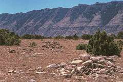
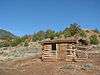
Bad Pass Trail |
|
000000001975-10-29-0000October 29, 1975
(#75000215) |
East of Warren along the Big Horn River in the Bighorn Canyon National Recreation Area
45°03′07″N 108°15′44″W / 45.051944°N 108.262222°W / 45.051944; -108.262222 (Bad Pass Trail) |
Warren |
|
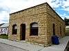
| 2 |
Baker and Lovering Store |
Upload image |
000000001986-05-02-0000May 2, 1986
(#86000885) |
Main St.
45°29′06″N 108°58′10″W / 45.485°N 108.969444°W / 45.485; -108.969444 (Baker and Lovering Store) |
Joliet |
|
| 3 |
Baldwin Building |
Upload image |
000000001993-01-28-0000January 28, 1993
(#92001777) |
Junction of W. River St. and Harley Ave.
45°23′31″N 108°54′25″W / 45.391944°N 108.906944°W / 45.391944; -108.906944 (Baldwin Building) |
Fromberg |
|
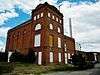
| 4 |
Bearcreek Bank |
|
000000002004-03-31-0000March 31, 2004
(#04000251) |
Main and 2nd Sts.
45°09′40″N 109°09′30″W / 45.161111°N 109.158333°W / 45.161111; -109.158333 (Bearcreek Bank) |
Bearcreek |
|
| 5 |
Bearcreek Cemetery |
Upload image |
000000002011-01-18-0000January 18, 2011
(#11000017) |
1 mile west of Bearcreek
45°09′30″N 109°08′21″W / 45.158333°N 109.139167°W / 45.158333; -109.139167 (Bearcreek Cemetery) |
Bearcreek |
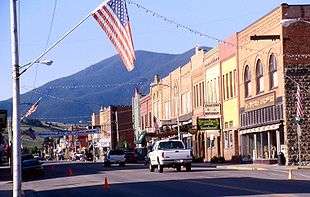
|
| 6 |
Dr. Theodore J. Benson House |
Upload image |
000000001993-01-28-0000January 28, 1993
(#92001780) |
10 N. Montana
45°23′33″N 108°54′32″W / 45.3925°N 108.908889°W / 45.3925; -108.908889 (Dr. Theodore J. Benson House) |
Fromberg |
|
| 7 |
John Blewett House |
Upload image |
000000001993-01-28-0000January 28, 1993
(#92001789) |
2411 E. River St.
45°23′30″N 108°54′05″W / 45.391667°N 108.901389°W / 45.391667; -108.901389 (John Blewett House) |
Fromberg |
|
| 8 |
Bluewater Creek Bridge |
Upload image |
000000002011-04-28-0000April 28, 2011
(#11000223) |
Milepost 8 on Bluewater Creek Rd.
45°22′10″N 108°52′56″W / 45.369444°N 108.882222°W / 45.369444; -108.882222 (Bluewater Creek Bridge) |
Fromberg |
|
| 9 |
Bridger Coal Company House |
Upload image |
000000001987-09-15-0000September 15, 1987
(#87001215) |
307 W. Broadway
45°17′46″N 108°55′00″W / 45.296111°N 108.916667°W / 45.296111; -108.916667 (Bridger Coal Company House) |
Bridger |
|
| 10 |
Bridger Opera House |
Upload image |
000000001987-09-15-0000September 15, 1987
(#87001217) |
E. Broadway
45°17′44″N 108°54′39″W / 45.295556°N 108.910833°W / 45.295556; -108.910833 (Bridger Opera House) |
Bridger |
|
| 11 |
Frank Brooder House |
Upload image |
000000001993-01-28-0000January 28, 1993
(#92001787) |
303 North St.
45°23′38″N 108°54′37″W / 45.393889°N 108.910278°W / 45.393889; -108.910278 (Frank Brooder House) |
Fromberg |
|
| 12 |
Calvary Episcopal Church |
|
000000001986-10-23-0000October 23, 1986
(#86002928) |
9 N. Villard Ave.
45°11′16″N 109°14′56″W / 45.187778°N 109.248889°W / 45.187778; -109.248889 (Calvary Episcopal Church) |
Red Lodge |
|
| 13 |
Camp Senia Historic District |
Upload image |
000000001988-04-14-0000April 14, 1988
(#88000441) |
Custer National Forest
45°10′15″N 109°28′34″W / 45.170833°N 109.476111°W / 45.170833; -109.476111 (Camp Senia Historic District) |
Red Lodge |
Boundary increased 2015-08-10
|
| 14 |
Cedarvale |
|
000000001975-08-19-0000August 19, 1975
(#75000161) |
Present town of Hillsboro and its environs in the Bighorn Canyon National Recreation Area
45°05′53″N 108°13′26″W / 45.098056°N 108.223889°W / 45.098056; -108.223889 (Cedarvale) |
Hillsboro |
|
| 15 |
Corey House |
Upload image |
000000001987-07-21-0000July 21, 1987
(#87001219) |
106 N. E St.
45°17′46″N 108°54′21″W / 45.296111°N 108.905833°W / 45.296111; -108.905833 (Corey House) |
Bridger |
|
| 16 |
Demijohn Flat Archeological District |
Upload image |
000000001974-11-20-0000November 20, 1974
(#74001092) |
Address Restricted
|
Bridger |
|
| 17 |
Ewing-Snell Ranch |
|
000000001977-05-12-0000May 12, 1977
(#77000114) |
South of Dryhead
45°05′02″N 108°15′49″W / 45.083889°N 108.263611°W / 45.083889; -108.263611 (Ewing-Snell Ranch) |
Dryhead |
|
| 18 |
Fire Hall |
Upload image |
000000001986-05-02-0000May 2, 1986
(#86000884) |
Main St.
45°29′05″N 108°58′10″W / 45.484722°N 108.969444°W / 45.484722; -108.969444 (Fire Hall) |
Joliet |
|
| 19 |
Forsman House |
Upload image |
000000001987-07-21-0000July 21, 1987
(#87001233) |
406 E. Carbon Ave.
45°17′35″N 108°54′29″W / 45.293056°N 108.908056°W / 45.293056; -108.908056 (Forsman House) |
Bridger |
|
| 20 |
Fromberg Concrete Arch Bridge |
|
000000001993-01-28-0000January 28, 1993
(#92001790) |
River St. over the Clarks Fork of the Yellowstone River
45°23′31″N 108°53′39″W / 45.391944°N 108.894167°W / 45.391944; -108.894167 (Fromberg Concrete Arch Bridge) |
Fromberg |
|
| 21 |
Fromberg High School |
Upload image |
000000001993-01-28-0000January 28, 1993
(#92001788) |
Kids Ct.
45°23′35″N 108°54′41″W / 45.393056°N 108.911389°W / 45.393056; -108.911389 (Fromberg High School) |
Fromberg |
|
| 22 |
Fromberg Methodist-Episcopal Church |
Upload image |
000000001993-01-28-0000January 28, 1993
(#92001781) |
Junction of N. Montana Ave. and School St.
45°23′34″N 108°54′32″W / 45.392778°N 108.908889°W / 45.392778; -108.908889 (Fromberg Methodist-Episcopal Church) |
Fromberg |
|
| 23 |
Fromberg Opera House |
Upload image |
000000001993-01-28-0000January 28, 1993
(#92001779) |
Junction of Harley Ave. and C St.
45°23′35″N 108°54′24″W / 45.393056°N 108.906667°W / 45.393056; -108.906667 (Fromberg Opera House) |
Fromberg |
|
| 24 |
Gebo Barn |
Upload image |
000000002005-06-01-0000June 1, 2005
(#05000512) |
2.5 miles south of Fromberg on River Rd.
45°21′15″N 108°54′19″W / 45.354167°N 108.905278°W / 45.354167; -108.905278 (Gebo Barn) |
Fromberg |
|
| 25 |
Gebo Cemetery |
Upload image |
000000001993-04-08-0000April 8, 1993
(#93000291) |
County road linking Gebo and Fromberg
45°24′12″N 108°55′23″W / 45.403333°N 108.923056°W / 45.403333; -108.923056 (Gebo Cemetery) |
Fromberg |
|
| 26 |
Henry Gebo House |
Upload image |
000000001987-07-21-0000July 21, 1987
(#87001234) |
East of Bridger
45°18′10″N 109°09′15″W / 45.302778°N 109.154167°W / 45.302778; -109.154167 (Henry Gebo House) |
Bridger |
|
| 27 |
John Gibson House |
Upload image |
000000001993-01-28-0000January 28, 1993
(#92001785) |
219 W. River St.
45°23′31″N 108°54′36″W / 45.391944°N 108.91°W / 45.391944; -108.91 (John Gibson House) |
Fromberg |
|
| 28 |
Glidden House |
Upload image |
000000001987-07-21-0000July 21, 1987
(#87001236) |
112 N. E St.
45°17′47″N 108°54′22″W / 45.296389°N 108.906111°W / 45.296389; -108.906111 (Glidden House) |
Bridger |
|
| 29 |
Glidden Mercantile |
Upload image |
000000001987-09-15-0000September 15, 1987
(#87001237) |
102 N. Main
45°17′46″N 108°54′49″W / 45.296111°N 108.913611°W / 45.296111; -108.913611 (Glidden Mercantile) |
Bridger |
|
| 30 |
Samuel Greenblatt House |
Upload image |
000000001993-01-28-0000January 28, 1993
(#92001784) |
215 W. River St.
45°23′31″N 108°54′34″W / 45.391944°N 108.909444°W / 45.391944; -108.909444 (Samuel Greenblatt House) |
Fromberg |
|
| 31 |
Heatherington Boarding House |
Upload image |
000000001987-09-15-0000September 15, 1987
(#87001240) |
209 E. Broadway
45°17′46″N 108°54′41″W / 45.296111°N 108.911389°W / 45.296111; -108.911389 (Heatherington Boarding House) |
Bridger |
|
| 32 |
Hi Bug Historic District |
|
000000001986-07-23-0000July 23, 1986
(#86001932) |
Roughly bounded by W. 3rd St., N. Villard Ave., W. 8th St., and N. Word Ave.
45°11′35″N 109°14′58″W / 45.193056°N 109.249444°W / 45.193056; -109.249444 (Hi Bug Historic District) |
Red Lodge |
|
| 33 |
Raymond Hough House |
Upload image |
000000001987-09-15-0000September 15, 1987
(#87001242) |
312 S. 2nd
45°17′35″N 108°54′54″W / 45.293056°N 108.915°W / 45.293056; -108.915 (Raymond Hough House) |
Bridger |
|
| 34 |
House on Railroad Avenue |
Upload image |
000000001986-05-02-0000May 2, 1986
(#86000889) |
Railroad Ave.
45°29′10″N 108°58′12″W / 45.486111°N 108.97°W / 45.486111; -108.97 (House on Railroad Avenue) |
Joliet |
|
| 35 |
IOOF Hall and Fromberg Co-operative Mercantile Building |
Upload image |
000000001993-01-28-0000January 28, 1993
(#92001778) |
123 W. River St.
45°23′31″N 108°54′31″W / 45.391944°N 108.908611°W / 45.391944; -108.908611 (IOOF Hall and Fromberg Co-operative Mercantile Building) |
Fromberg |
|
| 36 |
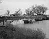
Joliet Bridge |
Upload image |
000000001986-05-02-0000May 2, 1986
(#86000888) |
Carries Main St. over Rock Creek
45°29′14″N 108°58′32″W / 45.487222°N 108.975556°W / 45.487222; -108.975556 (Joliet Bridge) |
Joliet |
|
| 37 |
Joliet High School |
Upload image |
000000001986-05-02-0000May 2, 1986
(#86000887) |
Main St.
45°29′15″N 108°58′23″W / 45.4875°N 108.973056°W / 45.4875; -108.973056 (Joliet High School) |
Joliet |
|
| 38 |
Joliet Residential Historic District |
Upload image |
000000001986-05-02-0000May 2, 1986
(#86000892) |
Roughly bounded by the Northern Pacific railroad line and U.S. Route 12, State St., Carbon Ave., and 2nd St.
45°29′04″N 108°58′11″W / 45.484444°N 108.969722°W / 45.484444; -108.969722 (Joliet Residential Historic District) |
Joliet |
|
| 39 |
Kent Dairy Round Barn |
Upload image |
000000001995-04-07-0000April 7, 1995
(#95000381) |
Along U.S. Route 212, 2 miles north of Red Lodge
45°13′09″N 109°14′29″W / 45.219167°N 109.241389°W / 45.219167; -109.241389 (Kent Dairy Round Barn) |
Red Lodge |
|
| 40 |
Kero Farmstead Historic District |
Upload image |
000000002007-08-16-0000August 16, 2007
(#07000815) |
223 W. Bench Rd.
45°17′32″N 109°13′05″W / 45.292222°N 109.218056°W / 45.292222; -109.218056 (Kero Farmstead Historic District) |
Roberts |
|
| 41 |
Kose Hall |
Upload image |
000000002013-04-09-0000April 9, 2013
(#13000152) |
216 Broadway Ave.
45°08′34″N 109°00′29″W / 45.142669°N 109.008021°W / 45.142669; -109.008021 (Kose Hall) |
Belfry |
|
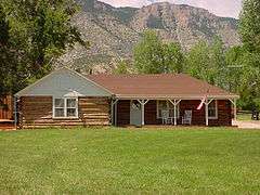
| 42 |
Caroline Lockhart Ranch |
|
000000001989-11-03-0000November 3, 1989
(#89000155) |
Davis Creek, 70 miles south of Hardin
45°08′17″N 108°14′24″W / 45.138056°N 108.24°W / 45.138056; -108.24 (Caroline Lockhart Ranch) |
Dead Hill |
|
| 43 |
Dr. Carl Marcus House |
Upload image |
000000001987-09-15-0000September 15, 1987
(#87001243) |
210 S. 2nd
45°17′41″N 108°54′54″W / 45.294722°N 108.915°W / 45.294722; -108.915 (Dr. Carl Marcus House) |
Bridger |
|
| 44 |
Tracy McCall House |
Upload image |
000000001993-01-28-0000January 28, 1993
(#92001782) |
110 N. Montana Ave.
45°23′36″N 108°54′32″W / 45.393333°N 108.908889°W / 45.393333; -108.908889 (Tracy McCall House) |
Fromberg |
|
| 45 |
Methodist Episcopal Church and Parsonage |
Upload image |
000000001987-09-15-0000September 15, 1987
(#87001244) |
220 W. Broadway
45°17′45″N 108°54′58″W / 45.295833°N 108.916111°W / 45.295833; -108.916111 (Methodist Episcopal Church and Parsonage) |
Bridger |
|
| 46 |
Montana, Wyoming and Southern Railroad Depot |
Upload image |
000000002012-10-03-0000October 3, 2012
(#12000828) |
403 Broadway Ave.
45°08′35″N 109°00′36″W / 45.142926°N 109.009953°W / 45.142926; -109.009953 (Montana, Wyoming and Southern Railroad Depot) |
Belfry |
|
| 47 |
Northern Pacific Railroad Depot-Fromberg |
Upload image |
000000001993-01-28-0000January 28, 1993
(#92001776) |
Junction of U.S. Route 310 and River St.
45°23′31″N 108°54′20″W / 45.391944°N 108.905556°W / 45.391944; -108.905556 (Northern Pacific Railroad Depot-Fromberg) |
Fromberg |
|
| 48 |
Nutting Rental |
Upload image |
000000001987-09-15-0000September 15, 1987
(#87001245) |
Carbon Ave.
45°17′39″N 108°54′55″W / 45.294167°N 108.915278°W / 45.294167; -108.915278 (Nutting Rental) |
Bridger |
|
| 49 |
Petroglyph Canyon |
Upload image |
000000001975-11-20-0000November 20, 1975
(#75001079) |
Southern half of Section 35, Township 9 South, Range 26 East[5]
45°00′20″N 108°30′14″W / 45.005556°N 108.503889°W / 45.005556; -108.503889 (Petroglyph Canyon) |
Warren |
|
| 50 |
Pretty Creek Archeological Site |
Upload image |
000000001975-01-17-0000January 17, 1975
(#75000162) |
Address Restricted
|
Hardin |
|
| 51 |
Francis Rahrer House |
Upload image |
000000001993-01-28-0000January 28, 1993
(#92001786) |
309 School St.
45°23′36″N 108°54′40″W / 45.393333°N 108.911111°W / 45.393333; -108.911111 (Francis Rahrer House) |
Fromberg |
|
| 52 |
Red Lodge Brewing Company-Red Lodge Canning Company |
|
000000002007-09-05-0000September 5, 2007
(#07000947) |
904 N. Bonner St.
45°11′46″N 109°14′40″W / 45.196111°N 109.244444°W / 45.196111; -109.244444 (Red Lodge Brewing Company-Red Lodge Canning Company) |
Red Lodge |
|
| 53 |
Red Lodge Commercial Historic District |
|
000000001983-04-14-0000April 14, 1983
(#83001057) |
Roughly Broadway from 8th to 13th Sts.; also S. Broadway between 8th and 15th Sts.
45°11′32″N 109°14′48″W / 45.192222°N 109.246667°W / 45.192222; -109.246667 (Red Lodge Commercial Historic District) |
Red Lodge |
Second set of boundaries represents a boundary increase, added on 000000001986-08-28-0000August 28, 1986
|
| 54 |
Red Lodge Communal Mausoleum |
Upload image |
000000002011-03-21-0000March 21, 2011
(#11000114) |
Montana Highway 78
45°11′41″N 109°15′41″W / 45.1947°N 109.2615°W / 45.1947; -109.2615 (Red Lodge Communal Mausoleum) |
Red Lodge |
|
| 55 |
Red Lodge-Cooke City Approach Road Historic District |
|
000000002014-05-08-0000May 8, 2014
(#14000219) |
US 212
45°10′14″N 109°15′26″W / 45.170556°N 109.257341°W / 45.170556; -109.257341 (Red Lodge-Cooke City Approach Road Historic District) |
Red Lodge |
Extends into Park County, Montana and Park County, Wyoming
|
| 56 |
Rock Creek State Bank |
Upload image |
000000001986-05-02-0000May 2, 1986
(#86000890) |
Main St.
45°29′04″N 108°58′12″W / 45.484444°N 108.97°W / 45.484444; -108.97 (Rock Creek State Bank) |
Joliet |
|
| 57 |
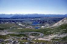
Rock Creek Ranger Station Historic District |
Upload image |
000000002016-10-17-0000October 17, 2016
(#16000729) |
6811 US 212
45°10′10″N 109°15′32″W / 45.169494°N 109.258814°W / 45.169494; -109.258814 (Rock Creek Ranger Station Historic District) |
Red Lodge vicinity |
|
| 58 |
T.W. Smith House |
Upload image |
000000001986-05-02-0000May 2, 1986
(#86000886) |
Front St.
45°29′20″N 108°57′46″W / 45.488889°N 108.962778°W / 45.488889; -108.962778 (T.W. Smith House) |
Joliet |
|
| 59 |
Smith Mine Historic District |
|
000000002009-09-30-0000September 30, 2009
(#09000788) |
Montana Highway 308
45°09′25″N 109°10′58″W / 45.156981°N 109.182892°W / 45.156981; -109.182892 (Smith Mine Historic District) |
Bearcreek |
|
| 60 |
Southern Hotel |
Upload image |
000000001986-05-02-0000May 2, 1986
(#86000891) |
Main St.
45°29′05″N 108°58′09″W / 45.484722°N 108.969167°W / 45.484722; -108.969167 (Southern Hotel) |
Joliet |
|
| 61 |
Hester E. Suydam Boarding House |
Upload image |
000000001993-01-28-0000January 28, 1993
(#92001783) |
209 W. River St.
45°23′31″N 108°54′33″W / 45.391944°N 108.909167°W / 45.391944; -108.909167 (Hester E. Suydam Boarding House) |
Fromberg |
|
| 62 |
Warila Boarding House and Sauna |
Upload image |
000000001985-10-24-0000October 24, 1985
(#85003382) |
20 N. Haggin
45°11′16″N 109°14′38″W / 45.187778°N 109.243889°W / 45.187778; -109.243889 (Warila Boarding House and Sauna) |
Red Lodge |
|
| 63 |
Wool Warehouse |
Upload image |
000000001987-07-21-0000July 21, 1987
(#87001246) |
E. Bridger
45°17′44″N 108°54′32″W / 45.295556°N 108.908889°W / 45.295556; -108.908889 (Wool Warehouse) |
Bridger |
|
| 64 |
Yodeler Motel |
Upload image |
000000002014-03-26-0000March 26, 2014
(#14000078) |
601 S. Broadway Ave.
45°10′51″N 109°14′50″W / 45.180812°N 109.247125°W / 45.180812; -109.247125 (Yodeler Motel) |
Red Lodge |
|