National Register of Historic Places listings in Cameron County, Texas
List of Registered Historic Places in Cameron County, Texas
This is intended to be a complete list of properties and districts listed on the National Register of Historic Places in Cameron County, Texas. The locations of National Register properties and districts (at least for all showing latitude and longitude coordinates below) may be seen in a map by clicking on "Map of all coordinates".[1]
- This National Park Service list is complete through NPS recent listings posted December 2, 2016.[2]
| [3] | Name on the Register[4] | Image | Date listed[5] | Location | City or town | Description |
|---|---|---|---|---|---|---|
| 1 | Brazos Santiago Depot | Upload image | (#71000923) |
Restricted |
Port Isabel | |
| 2 | Samuel Wallace Brooks House | 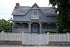 |
(#88002530) |
623 E St. Charles St. 25°54′14″N 97°30′12″W / 25.90375°N 97.503472°W |
Brownsville | |
| 3 | Brown-Wagner House | 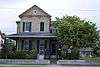 |
(#77001430) |
245 E St. Charles St. 25°54′23″N 97°30′22″W / 25.90625°N 97.506042°W |
Brownsville | |
| 4 | Brownsville City Cemetery and Hebrew Cemetery |  |
(#10000143) |
Bound by E. 5th St., Madison St., E 2nd St., and Town Resaca 25°54′34″N 97°30′00″W / 25.909514°N 97.5°W |
Brownsville | |
| 5 | Old Brulay Plantation | Upload image | (#75001961) |
East of Brownsville off of TX 4 25°51′16″N 97°24′01″W / 25.854531°N 97.400289°W |
Brownsville | Also known as the Nye Plantation[6] |
| 6 | Cameron County Courthouse | 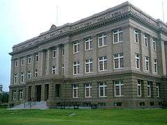 |
(#80004084) |
1150 E Madison St. 25°54′15″N 97°29′43″W / 25.904167°N 97.495347°W |
Brownsville | |
| 7 | Old Cameron County Jail | 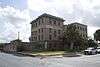 |
(#94001594) |
1201 E Van Buren 25°54′19″N 97°29′34″W / 25.905278°N 97.492847°W |
Brownsville | |
| 8 | Augustine Celaya House | 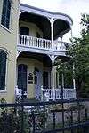 |
(#86000726) |
504 E St. Francis St. 25°54′13″N 97°30′19″W / 25.903681°N 97.505347°W |
Brownsville | |
| 9 | Celaya-Creager House |  |
(#88000523) |
441 E Washington St. 25°54′25″N 97°30′09″W / 25.906806°N 97.5025°W |
Brownsville | |
| 10 | Miguel Fernandez Hide Yard |  |
(#90001485) |
1101-1121 E Adams St. 25°54′11″N 97°29′51″W / 25.902947°N 97.497414°W |
Brownsville | also known as El Aleman |
| 11 | Fort Brown | 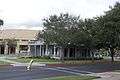 |
(#66000811) |
S edge of Brownsville off of International Blvd. 25°53′50″N 97°29′26″W / 25.897222°N 97.490556°W |
Brownsville | |
| 12 | Garcia Pasture Site | Upload image | (#72001355) |
Restricted |
Port Isabel | |
| 13 | The Gem |  |
(#91000852) |
400 E 13th St. 25°54′00″N 97°29′52″W / 25.89989°N 97.49768°W |
Brownsville | |
| 14 | Hicks-Gregg House | 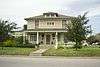 |
(#09000486) |
1249 W. Washington 25°55′06″N 97°30′56″W / 25.918375°N 97.515536°W |
Brownsville | |
| 15 | Immaculate Conception Church |  |
(#80004085) |
1218 E Jefferson St. 25°54′09″N 97°29′45″W / 25.9025°N 97.495972°W |
Brownsville | |
| 16 | La Madrilena | 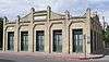 |
(#88002384) |
1002 E Madison 25°54′17″N 97°29′49″W / 25.904722°N 97.496806°W |
Brownsville | |
| 17 | Manautou House | 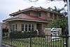 |
(#83003130) |
5 E Elizabeth St. 25°54′33″N 97°30′23″W / 25.909236°N 97.506458°W |
Brownsville | |
| 18 | McNair House | 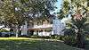 |
(#15000836) |
39 Sunset Drive 25°55′08″N 97°29′52″W / 25.918960°N 97.497848°W |
Brownsville | |
| 19 | Morris-Browne House |  |
(#06000955) |
204 E Levee St. 25°54′25″N 97°30′22″W / 25.90695°N 97.506111°W |
Brownsville | |
| 20 | La Nueva Libertad |  |
(#84001628) |
1301 E Madison 25°54′10″N 97°29′40″W / 25.902778°N 97.494375°W |
Brownsville | also known as the Cueto Building |
| 21 | Palmito Ranch Battlefield | |
(#93000266) |
Between TX 4 and the Rio Grande, 12 mi. E of Brownsville 25°56′48″N 97°17′07″W / 25.946667°N 97.285278°W |
Brownsville | |
| 22 | Palo Alto Battlefield National Historical Park |  |
(#66000812) |
6.3 miles N of Brownsville at intersection of FM 1847 and FM 511 26°01′04″N 97°28′50″W / 26.017886°N 97.480617°W |
Brownsville | Ref #66000812 |
| 23 | Point Isabel Lighthouse | 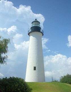 |
(#76002014) |
Corner of TX 100 and Garcia St. 26°04′39″N 97°12′27″W / 26.077633°N 97.207583°W |
Port Isabel | |
| 24 | Resaca De La Palma Battlefield | |
(#66000813) |
North of intersection of Paredes Line Rd and Price Rd. 25°56′15″N 97°29′10″W / 25.9375°N 97.486111°W |
Brownsville | Now a portion of the Palo Alto Battlefield National Historical Park |
| 25 | Southern Pacific Railroad Passenger Depot | 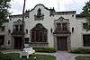 |
(#78002903) |
601 E Madison St. 25°54′27″N 97°29′57″W / 25.9075°N 97.499236°W |
Brownsville | |
| 26 | Charles Stillman House | 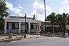 |
(#79003448) |
1305 E Washington St. 25°54′03″N 97°29′47″W / 25.900833°N 97.496319°W |
Brownsville |
See also
| Wikimedia Commons has media related to National Register of Historic Places in Cameron County, Texas. |
References
- ↑ The latitude and longitude information provided in this table was derived originally from the National Register Information System, which has been found to be fairly accurate for about 99% of listings. For about 1% of NRIS original coordinates, experience has shown that one or both coordinates are typos or otherwise extremely far off; some corrections may have been made. A more subtle problem causes many locations to be off by up to 150 yards, depending on location in the country: most NRIS coordinates were derived from tracing out latitude and longitudes off of USGS topographical quadrant maps created under the North American Datum of 1927, which differs from the current, highly accurate WGS84 GPS system used by most on-line maps. Chicago is about right, but NRIS longitudes in Washington are higher by about 4.5 seconds, and are lower by about 2.0 seconds in Maine. Latitudes differ by about 1.0 second in Florida. Some locations in this table may have been corrected to current GPS standards.
- ↑ "National Register of Historic Places: Weekly List Actions". National Park Service, United States Department of the Interior. Retrieved on December 2, 2016.
- ↑ Numbers represent an ordering by significant words. Various colorings, defined here, differentiate National Historic Landmarks and historic districts from other NRHP buildings, structures, sites or objects.
- ↑ National Park Service (2008-04-24). "National Register Information System". National Register of Historic Places. National Park Service.
- ↑ The eight-digit number below each date is the number assigned to each location in the National Register Information System database, which can be viewed by clicking the number.
- ↑
 |
Willacy County | | ||
| Hidalgo County | |
Gulf of Mexico | ||
| ||||
| | ||||
| Matamoros, Tamaulipas, Mexico |
| Topics | |
|---|---|
| Lists by states |
|
| Lists by insular areas | |
| Lists by associated states | |
| Other areas | |
| |
This article is issued from Wikipedia - version of the 8/22/2016. The text is available under the Creative Commons Attribution/Share Alike but additional terms may apply for the media files.