| [3] |
Name on the Register |
Image |
Date listed[4] |
Location |
City or town |
Description |
|---|
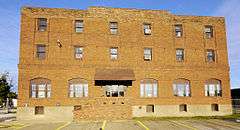
| 1 |
Baltimore and Ohio Railroad Depot |
|
000000001973-10-30-0000October 30, 1973
(#73001897) |
1100 block of Veterans Memorial Boulevard
38°25′24″N 82°26′33″W / 38.423333°N 82.4425°W / 38.423333; -82.4425 (Baltimore and Ohio Railroad Depot) |
Huntington |
|
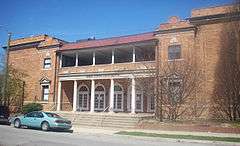
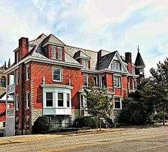
| 2 |
Barboursville Historic District |
|
000000002008-12-24-0000December 24, 2008
(#08001234) |
Water, Main, and Brady Sts. and Central Ave.
38°24′35″N 82°17′42″W / 38.40982°N 82.29509°W / 38.40982; -82.29509 (Barboursville Historic District) |
Barboursville |
|
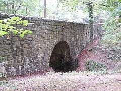
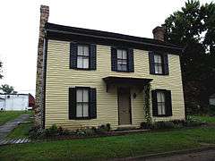
| 3 |
Barnett Hospital and Nursing School |
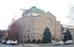
|
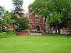
000000002009-12-30-0000December 30, 2009
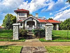
(#09001190) |
1201 7th Ave.
38°25′03″N 82°26′15″W / 38.417617°N 82.437514°W / 38.417617; -82.437514 (Barnett Hospital and Nursing School) |
Huntington |
|
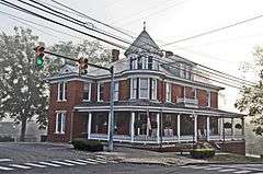
| 4 |
Cabell County Courthouse |
|
000000001982-09-02-0000September 2, 1982
(#82004313) |
5th Ave. and 8th St.
38°25′11″N 82°26′47″W / 38.419722°N 82.446389°W / 38.419722; -82.446389 (Cabell County Courthouse) |
Huntington |
|
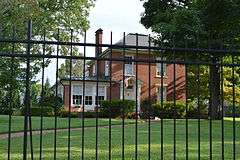
| 5 |
Campbell-Hicks House |
|
000000001985-08-19-0000August 19, 1985
(#85001814) |
1102 5th Ave.
38°25′12″N 82°26′21″W / 38.42°N 82.439167°W / 38.42; -82.439167 (Campbell-Hicks House) |
Huntington |
|
| 6 |
Carnegie Public Library |
|
000000001980-04-03-0000April 3, 1980
(#80004015) |
900 5th Ave.
38°25′11″N 82°26′36″W / 38.419722°N 82.443333°W / 38.419722; -82.443333 (Carnegie Public Library) |
Huntington |
|
| 7 |
Thomas Carroll House |
|
000000001973-06-01-0000June 1, 1973
(#73001898) |
234 Guyan St.
38°25′44″N 82°23′24″W / 38.428889°N 82.39°W / 38.428889; -82.39 (Thomas Carroll House) |
Huntington |
|
| 8 |
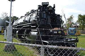
Chesapeake and Ohio 1308 Steam Locomotive |
|
000000002003-01-31-0000January 31, 2003
(#02001571) |
1401 Memorial Boulevard
38°24′19″N 82°28′38″W / 38.405139°N 82.477222°W / 38.405139; -82.477222 (Chesapeake and Ohio 1308 Steam Locomotive) |
Huntington |
|
| 9 |
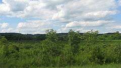
Clover Site |
|
000000001992-04-27-0000April 27, 1992
(#92001881) |
20 miles (32 km) above Huntington in the Green Bottom Wildlife Management Area[5]
38°35′24″N 82°13′54″W / 38.590000°N 82.231667°W / 38.590000; -82.231667 (Clover Site) |
Lesage |
Fields along and above the Ohio River; a major Fort Ancient-period village site[6]
|
| 10 |
Douglass Junior and Senior High School |
|
000000001985-12-05-0000December 5, 1985
(#85003091) |
10th Ave. and Bruce St.
38°24′52″N 82°25′53″W / 38.414444°N 82.431389°W / 38.414444; -82.431389 (Douglass Junior and Senior High School) |
Huntington |
|
| 11 |
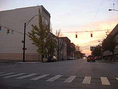
Downtown Huntington Historic District |
|
000000001986-02-24-0000February 24, 1986
(#86000309) |
Roughly bounded by 3rd Ave., 10th St., 5th Ave., and 7th and 8th Sts.; also portions of 3rd Ave. to the alley between 6th and 7th Aves. and from 12th St. to 7th St.
38°25′02″N 82°26′11″W / 38.417222°N 82.436389°W / 38.417222; -82.436389 (Downtown Huntington Historic District) |
Huntington |
Second set of boundaries represents a boundary increase of 000000002007-03-22-0000March 22, 2007
|
| 12 |
Elk River Coal and Lumber Company No. 10 Steam Locomotive |
|
000000002006-09-28-0000September 28, 2006
(#06000901) |
Junction of Veterans Memorial Boulevard and 11th St.
38°25′25″N 82°26′27″W / 38.423611°N 82.440833°W / 38.423611; -82.440833 (Elk River Coal and Lumber Company No. 10 Steam Locomotive) |
Huntington |
|
| 13 |
Foster Memorial Home |
|
000000002001-02-27-0000February 27, 2001
(#00001311) |
700 Madison Ave.
38°24′46″N 82°28′01″W / 38.412778°N 82.466944°W / 38.412778; -82.466944 (Foster Memorial Home) |
Huntington |
|
| 14 |
Freeman Estate |
Upload image |
000000002009-04-23-0000April 23, 2009
(#09000243) |
1805 McCoy Rd.
38°24′02″N 82°26′10″W / 38.400511°N 82.436014°W / 38.400511; -82.436014 (Freeman Estate) |
Huntington |
|
| 15 |
Harvey House |
|
000000001972-08-21-0000August 21, 1972
(#72001285) |
1305 3rd Ave.
38°25′24″N 82°26′15″W / 38.423333°N 82.4375°W / 38.423333; -82.4375 (Harvey House) |
Huntington |
|
| 16 |
Hawthorne Historic District |
Upload image |
000000002007-08-02-0000August 2, 2007
(#07000786) |
Roughly Hawthorne Way and portions of S. Whitaker Boulevard
38°24′22″N 82°26′39″W / 38.406233°N 82.44405°W / 38.406233; -82.44405 (Hawthorne Historic District) |
Huntington |
|
| 17 |
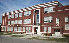
Huntington High School |
|
000000002000-04-04-0000April 4, 2000
(#00000248) |
900 8th St.
38°24′49″N 82°26′36″W / 38.413611°N 82.443333°W / 38.413611; -82.443333 (Huntington High School) |
Huntington |
|
| 18 |
Gen. Albert Gallatin Jenkins House |
|
000000001978-05-22-0000May 22, 1978
(#78002791) |
8814 Ohio River Rd.
38°35′12″N 82°14′58″W / 38.586667°N 82.249444°W / 38.586667; -82.249444 (Gen. Albert Gallatin Jenkins House) |
Green Bottom |
|
| 19 |
Johnston-Meek House |
|
000000002004-04-14-0000April 14, 2004
(#04000313) |
203 6th Ave.
38°24′56″N 82°27′17″W / 38.415556°N 82.454722°W / 38.415556; -82.454722 (Johnston-Meek House) |
Huntington |
|
| 20 |
Kenwood |
Upload image |
000000002007-08-02-0000August 2, 2007
(#07000784) |
619 Ridgewood Rd.
38°24′10″N 82°26′43″W / 38.402778°N 82.445278°W / 38.402778; -82.445278 (Kenwood) |
Huntington |
|
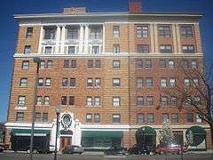
| 21 |
Liggett and Myers Tobacco Company |
|
000000001998-08-14-0000August 14, 1998
(#98001073) |
9 27th St.
38°26′02″N 82°24′33″W / 38.433889°N 82.409167°W / 38.433889; -82.409167 (Liggett and Myers Tobacco Company) |
Huntington |
|
| 22 |
Masonic Temple-Watts, Ritter, Wholesale Drygoods Company Building |
|
000000001993-08-26-0000August 26, 1993
(#93000614) |
1100-1108 E. 3rd Ave.
38°25′22″N 82°26′28″W / 38.422778°N 82.441111°W / 38.422778; -82.441111 (Masonic Temple-Watts, Ritter, Wholesale Drygoods Company Building) |
Huntington |
|
| 23 |
Memorial Arch |
|
000000001981-04-16-0000April 16, 1981
(#81000597) |
Memorial Park
38°24′23″N 82°27′46″W / 38.406389°N 82.462778°W / 38.406389; -82.462778 (Memorial Arch) |
Huntington |
|
| 24 |
Morris Memorial Hospital for Crippled Children |
Upload image |
000000002013-05-08-0000May 8, 2013
(#13000262) |
Morris Memorial Rd. between the James River Turnpike and U.S. Route 60
38°25′14″N 82°06′28″W / 38.420604°N 82.10788°W / 38.420604; -82.10788 (Morris Memorial Hospital for Crippled Children) |
Milton |
|
| 25 |
Mortimer Place Historic District |
|
000000002001-03-12-0000March 12, 2001
(#01000266) |
Bounded by an alley, 10th St., 12th Ave., and 11th St.
38°24′35″N 82°26′17″W / 38.409722°N 82.438056°W / 38.409722; -82.438056 (Mortimer Place Historic District) |
Huntington |
|
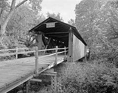
| 26 |
Mud River Covered Bridge |
|
000000001975-06-10-0000June 10, 1975
(#75001883) |
Off U.S. Route 60 on County Route 25 over the Mud River
38°25′51″N 82°08′22″W / 38.430833°N 82.139444°W / 38.430833; -82.139444 (Mud River Covered Bridge) |
Milton |
|
| 27 |
Ninth Street West Historic District |
|
000000001980-11-28-0000November 28, 1980
(#80004016) |
9th St. West and Madison and Jefferson Aves.
38°24′44″N 82°28′14″W / 38.412222°N 82.470556°W / 38.412222; -82.470556 (Ninth Street West Historic District) |
Huntington |
|
| 28 |
Ohev Sholom Temple |
|
000000001994-03-17-0000March 17, 1994
(#94000211) |
949 10th Ave.
38°24′44″N 82°26′24″W / 38.412222°N 82.44°W / 38.412222; -82.44 (Ohev Sholom Temple) |
Huntington |
|
| 29 |
Old Main, Marshall University |
|
000000001973-07-16-0000July 16, 1973
(#73001899) |
Hal Greer Boulevard on the Marshall University campus
38°25′23″N 82°25′47″W / 38.423056°N 82.429722°W / 38.423056; -82.429722 (Old Main, Marshall University) |
Huntington |
|
| 30 |
Prichard House |
|
000000002001-03-12-0000March 12, 2001
(#01000261) |
500 12th Ave.
38°24′31″N 82°26′51″W / 38.408611°N 82.4475°W / 38.408611; -82.4475 (Prichard House) |
Huntington |
|
| 31 |
Ricketts House |
|
000000001994-07-15-0000July 15, 1994
(#94000721) |
2301 Washington Boulevard
38°24′21″N 82°24′44″W / 38.405833°N 82.412222°W / 38.405833; -82.412222 (Ricketts House) |
Huntington |
|
| 32 |
Ritter Park Historic District |
|
000000001990-11-28-0000November 28, 1990
(#90001774) |
Ritter Park, including northern boundary streets
38°24′15″N 82°26′16″W / 38.404167°N 82.437778°W / 38.404167; -82.437778 (Ritter Park Historic District) |
Huntington |
|
| 33 |
Rotary Park Bridge |
|
000000002002-12-12-0000December 12, 2002
(#02001525) |
Rotary Park, 31 St., and Rotary Dr.
38°25′07″N 82°23′39″W / 38.418611°N 82.394167°W / 38.418611; -82.394167 (Rotary Park Bridge) |
Huntington |
|
| 34 |
Simms School Building |
|
000000001997-05-12-0000May 12, 1997
(#96000438) |
1680 11th Ave.
38°24′50″N 82°25′34″W / 38.413889°N 82.426111°W / 38.413889; -82.426111 (Simms School Building) |
Huntington |
|
| 35 |
Thornburg House |
|
000000001991-04-25-0000April 25, 1991
(#91000451) |
700 Main St.
38°24′35″N 82°17′40″W / 38.409722°N 82.294444°W / 38.409722; -82.294444 (Thornburg House) |
Barboursville |
|
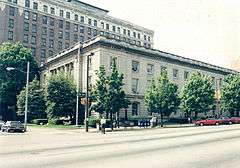
| 36 |
U.S. Post Office and Courthouse |
|
000000001982-04-15-0000April 15, 1982
(#82004314) |
845 5th Ave.[7]
38°25′08″N 82°26′38″W / 38.418889°N 82.443889°W / 38.418889; -82.443889 (U.S. Post Office and Courthouse) |
Huntington |
|
| 37 |
Zachary Taylor Wellington House |
|
000000002008-12-24-0000December 24, 2008
(#08001235) |
415 Main St.
38°25′29″N 82°23′23″W / 38.42477°N 82.38965°W / 38.42477; -82.38965 (Zachary Taylor Wellington House) |
Huntington |
|
| 38 |
West Virginia Colored Children's Home |
|
000000001997-11-13-0000November 13, 1997
(#97001413) |
3353 U.S. Route 60
38°24′34″N 82°22′25″W / 38.409444°N 82.373611°W / 38.409444; -82.373611 (West Virginia Colored Children's Home) |
Huntington |
Demolished on May 5, 2011 to make room for a new middle school.[8][9] |


.jpg)