National Register of Historic Places listings in Bingham County, Idaho

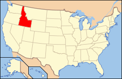
Location of Bingham County in Idaho
This is a list of the National Register of Historic Places listings in Bingham County, Idaho.
This is intended to be a complete list of the properties and districts on the National Register of Historic Places in Bingham County, Idaho, United States. Latitude and longitude coordinates are provided for many National Register properties and districts; these locations may be seen together in a map.[1]
There are 17 properties and districts listed on the National Register in the county. More may be added; properties and districts nationwide are added to the Register weekly.[2]
- This National Park Service list is complete through NPS recent listings posted December 16, 2016.[3]
Current listings
| [4] | Name on the Register[5] | Image | Date listed[6] | Location | City or town | Description |
|---|---|---|---|---|---|---|
| 1 | Aviator's Cave |  |
(#09001224) |
Grounds of Idaho National Laboratory[7] Coordinates missing |
Arco | |
| 2 | Blackfoot I.O.O.F. Hall |  |
(#79000775) |
57 Bridge St. 43°11′22″N 112°20′41″W / 43.189444°N 112.344722°W |
Blackfoot | |
| 3 | Blackfoot LDS Tabernacle |  |
(#77000456) |
120 S. Shilling St. 43°11′12″N 112°20′34″W / 43.186667°N 112.342778°W |
Blackfoot | |
| 4 | Blackfoot Railway Depot | 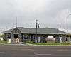 |
(#74000731) |
130 NW Main St. 43°11′22″N 112°20′35″W / 43.189444°N 112.343056°W |
Blackfoot | Now houses the Idaho Potato Museum |
| 5 | Eastern Idaho District Fair Historic District |  |
(#01000864) |
97 Park Dr. 43°11′45″N 112°20′23″W / 43.195833°N 112.339722°W |
Blackfoot | |
| 6 | Fort Hall Site |  |
(#74000732) |
16 miles north of Fort Hall Coordinates missing |
Fort Hall | Site of the second Fort Hall (1870-1883). |
| 7 | Idaho Republican Building | 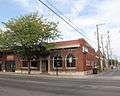 |
(#79000776) |
167 W. Bridge St. 43°11′24″N 112°20′44″W / 43.19°N 112.345556°W |
Blackfoot | |
| 8 | J.W. Jones Building | 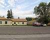 |
(#82000319) |
104 Main St., NE. 43°11′23″N 112°20′38″W / 43.189722°N 112.343889°W |
Blackfoot | |
| 9 | Lincoln Creek Day School | Upload image | (#10000174) |
Rich Lane, eight miles southeast of Idaho State Highway 91 43°11′19″N 112°12′14″W / 43.1886°N 112.2038°W |
Blackfoot | |
| 10 | North Shilling Historic District | 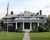 |
(#79000777) |
N. Shilling Ave. 43°11′19″N 112°20′28″W / 43.188611°N 112.341111°W |
Blackfoot | |
| 11 | Nuart Theater | 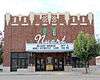 |
(#78001049) |
195 N. Broadway 43°11′27″N 112°20′38″W / 43.190833°N 112.343889°W |
Blackfoot | |
| 12 | Ross Fork Episcopal Church |  |
(#83000277) |
Mission Rd. 43°11′23″N 112°20′38″W / 43.189722°N 112.343889°W |
Fort Hall | |
| 13 | Ross Fork Oregon Short Lines Railroad Depot |  |
(#84001019) |
Agency Rd. 43°01′47″N 112°25′51″W / 43.029722°N 112.430833°W |
Fort Hall | |
| 14 | St. Paul's Episcopal Church |  |
(#79000778) |
72 N. Shilling Ave. 43°11′17″N 112°20′29″W / 43.188056°N 112.341389°W |
Blackfoot | |
| 15 | Shilling Avenue Historic District | 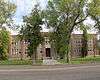 |
(#83000278) |
Shilling Ave. between E. Idaho and Bingham Sts. and Bridge and Judicial Sts. to Stout Ave. 43°11′13″N 112°20′32″W / 43.186944°N 112.342222°W |
Blackfoot | |
| 16 | Standrod Bank |  |
(#79000779) |
59 and 75 Main St., W. 43°11′22″N 112°20′40″W / 43.189444°N 112.344444°W |
Blackfoot | |
| 17 | US Post Office-Blackfoot Main |  |
(#89000128) |
165 W. Pacific 43°11′27″N 112°20′42″W / 43.190833°N 112.345°W |
Blackfoot |
See also
| Wikimedia Commons has media related to National Register of Historic Places in Bingham County, Idaho. |
References
- ↑ The latitude and longitude information provided in this table was derived originally from the National Register Information System, which has been found to be fairly accurate for about 99% of listings. For about 1% of NRIS original coordinates, experience has shown that one or both coordinates are typos or otherwise extremely far off; some corrections may have been made. A more subtle problem causes many locations to be off by up to 150 yards, depending on location in the country: most NRIS coordinates were derived from tracing out latitude and longitudes off of USGS topographical quadrant maps created under the North American Datum of 1927, which differs from the current, highly accurate WGS84 GPS system used by most on-line maps. Chicago is about right, but NRIS longitudes in Washington are higher by about 4.5 seconds, and are lower by about 2.0 seconds in Maine. Latitudes differ by about 1.0 second in Florida. Some locations in this table may have been corrected to current GPS standards.
- ↑ "National Register of Historic Places: Weekly List Actions". National Park Service. Retrieved March 29, 2009.
- ↑ "National Register of Historic Places: Weekly List Actions". National Park Service, United States Department of the Interior. Retrieved on December 16, 2016.
- ↑ Numbers represent an ordering by significant words. Various colorings, defined here, differentiate National Historic Landmarks and historic districts from other NRHP buildings, structures, sites or objects.
- ↑ National Park Service (2008-04-24). "National Register Information System". National Register of Historic Places. National Park Service.
- ↑ The eight-digit number below each date is the number assigned to each location in the National Register Information System database, which can be viewed by clicking the number.
- ↑ Stacy, Susan M. Proving the Principle: A History of the Idaho National Engineering and Environmental Laboratory, 1949-1999. Idaho Falls: USDOE, 2000, 4.

Municipalities and communities of Bingham County, Idaho, United States | ||
|---|---|---|
| Cities | ||
| CDPs | ||
| Unincorporated communities | ||
| Indian reservation | ||
| Footnotes | ‡This populated place also has portions in an adjacent county or counties | |
| Topics | |
|---|---|
| Lists by states |
|
| Lists by insular areas | |
| Lists by associated states | |
| Other areas | |
| |
This article is issued from Wikipedia - version of the 4/2/2016. The text is available under the Creative Commons Attribution/Share Alike but additional terms may apply for the media files.