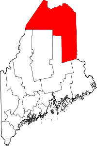
| [3] |
Name on the Register[4] |
Image |
Date listed[5] |
Location |
City or town |
Description |
|---|
| 1 |
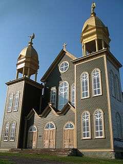
Acadian Historic Buildings |
|
000000001977-12-13-0000December 13, 1977
(#77000062) |
North of Van Buren on U.S. Route 1
47°12′17″N 67°59′26″W / 47.204722°N 67.990556°W / 47.204722; -67.990556 (Acadian Historic Buildings) |
Van Buren |
Buildings at the Acadian Village Museum
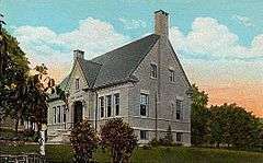
|
| 2 |
Acadian Landing Site |
|
000000001973-09-20-0000September 20, 1973
(#73000098) |
East of Madawaska on the St. John River off U.S. Route 1
47°21′10″N 68°16′23″W / 47.3528°N 68.2731°W / 47.3528; -68.2731 (Acadian Landing Site) |
Madawaska |
|
| 3 |
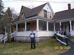
Amazeen House |
Upload image |
000000001986-09-11-0000September 11, 1986
(#86002470) |
15 Weeks St.
46°07′08″N 67°50′17″W / 46.118889°N 67.838056°W / 46.118889; -67.838056 (Amazeen House) |
Houlton |
|
| 4 |
Anderson Bros. Store |
Upload image |
000000002001-01-11-0000January 11, 2001
(#00001635) |
280 Main St.
47°02′20″N 68°08′28″W / 47.038889°N 68.141111°W / 47.038889; -68.141111 (Anderson Bros. Store) |
Stockholm |
|
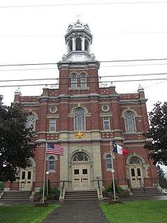
| 5 |
Aroostook County Courthouse and Jail |
|
000000001990-01-26-0000January 26, 1990
(#89002340) |
Court St.
46°07′29″N 67°50′23″W / 46.124722°N 67.839722°W / 46.124722; -67.839722 (Aroostook County Courthouse and Jail) |
Houlton |
|
| 6 |
Big Black Site |
Upload image |
000000001975-09-09-0000September 9, 1975
(#75000090) |
Address Restricted
|
Eagle Lake |
|
| 7 |
Bridgewater Town Hall and Jail |
Upload image |
000000001990-01-26-0000January 26, 1990
(#89002339) |
U.S. Route 1
46°14′45″N 67°50′50″W / 46.245833°N 67.847222°W / 46.245833; -67.847222 (Bridgewater Town Hall and Jail) |
Bridgewater |
|
| 8 |
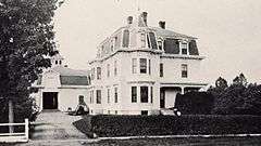
Cary Library |
|
000000001987-06-25-0000June 25, 1987
(#87000929) |
107 Main St.
46°07′31″N 67°50′17″W / 46.125278°N 67.838056°W / 46.125278; -67.838056 (Cary Library) |
Houlton |
|
| 9 |
Church of the Advent |
Upload image |
000000001991-06-21-0000June 21, 1991
(#91000767) |
Church St., 1 block south of its junction with State Route 229
46°54′38″N 67°49′30″W / 46.910556°N 67.825°W / 46.910556; -67.825 (Church of the Advent) |
Limestone |
|
| 10 |
Nicholas P. Clase House |
Upload image |
000000001989-10-16-0000October 16, 1989
(#89001699) |
Capitol Hill Rd.
46°56′30″N 68°07′22″W / 46.941667°N 68.122778°W / 46.941667; -68.122778 (Nicholas P. Clase House) |
New Sweden |
|
| 11 |
Edward L. Cleveland House |
Upload image |
000000001987-06-12-0000June 12, 1987
(#87000939) |
87 Court St.
46°07′02″N 67°50′28″W / 46.117222°N 67.841111°W / 46.117222; -67.841111 (Edward L. Cleveland House) |
Houlton |
|
| 12 |
Jean-Baptiste Daigle House |
Upload image |
000000002013-10-16-0000October 16, 2013
(#13000833) |
4 Dube St.
47°15′30″N 68°35′23″W / 47.258238°N 68.58978°W / 47.258238; -68.58978 (Jean-Baptiste Daigle House) |
Fort Kent |
|
| 13 |
Donovan-Hussey Farms Historic District |
Upload image |
000000002009-02-13-0000February 13, 2009
(#09000012) |
546 and 535 Ludlow Rd.
46°08′50″N 67°53′32″W / 46.1472°N 67.8921°W / 46.1472; -67.8921 (Donovan-Hussey Farms Historic District) |
Houlton |
|
| 14 |
Beecher H. Duncan Farm |
Upload image |
000000002009-02-11-0000February 11, 2009
(#09000011) |
26 Shorey Rd.
46°35′38″N 67°58′59″W / 46.593972°N 67.982977°W / 46.593972; -67.982977 (Beecher H. Duncan Farm) |
Westfield |
|
| 15 |
The Elms |
Upload image |
000000002009-07-22-0000July 22, 2009
(#09000549) |
59 Court St.
46°07′18″N 67°50′24″W / 46.121567°N 67.839878°W / 46.121567; -67.839878 (The Elms) |
Houlton |
|
| 16 |
First National Bank of Houlton |
Upload image |
000000001973-09-20-0000September 20, 1973
(#73000099) |
Market Sq.
46°07′25″N 67°50′42″W / 46.123611°N 67.845°W / 46.123611; -67.845 (First National Bank of Houlton) |
Houlton |
|
| 17 |
Fort Fairfield Public Library |
|
000000001989-01-05-0000January 5, 1989
(#88003021) |
Main St.
46°46′20″N 67°50′04″W / 46.772222°N 67.834444°W / 46.772222; -67.834444 (Fort Fairfield Public Library) |
Fort Fairfield |
|
| 18 |
Fort Kent |
|
000000001969-12-01-0000December 1, 1969
(#69000005) |
At the confluence of Fish and St. John Rivers
47°15′10″N 68°35′42″W / 47.2528°N 68.5951°W / 47.2528; -68.5951 (Fort Kent) |
Fort Kent |
|
| 19 |
Fort Kent Railroad Station |
|
000000001989-04-21-0000April 21, 1989
(#89000249) |
Junction of Main and Market Sts.
47°15′27″N 68°35′23″W / 47.2575°N 68.5897°W / 47.2575; -68.5897 (Fort Kent Railroad Station) |
Fort Kent |
|
| 20 |
Frenchville Railroad Station and Water Tank |
Upload image |
000000001995-06-20-0000June 20, 1995
(#95000723) |
308 U.S. Route 1
47°16′47″N 68°23′20″W / 47.279722°N 68.388889°W / 47.279722; -68.388889 (Frenchville Railroad Station and Water Tank) |
Frenchville |
|
| 21 |
Governor Brann School |
|
000000001993-12-23-0000December 23, 1993
(#93001432) |
Eastern side of U.S. Route 1, 1.25 miles south of its junction with Madore Rd.
47°07′18″N 67°57′42″W / 47.1216°N 67.9617°W / 47.1216; -67.9617 (Governor Brann School) |
Cyr Plantation |
Listed in Van Buren; building is town hall of Cyr Plantation.
|
| 22 |
Gray Memorial United Methodist Church and Parsonage |
|
000000001995-06-20-0000June 20, 1995
(#95000725) |
8 Prospect St.
46°51′37″N 68°01′02″W / 46.860278°N 68.017222°W / 46.860278; -68.017222 (Gray Memorial United Methodist Church and Parsonage) |
Caribou |
|
| 23 |
Gustaf Adolph Lutheran Church |
|
000000001997-06-20-0000June 20, 1997
(#97000608) |
Eastern side of Capitol Hill Rd., 0.5 miles north of its junction with State Route 161
46°56′19″N 68°07′14″W / 46.938611°N 68.120556°W / 46.938611; -68.120556 (Gustaf Adolph Lutheran Church) |
New Sweden |
|
| 24 |
Island Falls Opera House |
|
000000001984-07-19-0000July 19, 1984
(#84001359) |
Patten Rd. and Sewall St.
46°00′31″N 68°16′13″W / 46.008611°N 68.270278°W / 46.008611; -68.270278 (Island Falls Opera House) |
Island Falls |
|
| 25 |
Pehr J. Jacobson House |
Upload image |
000000002007-02-07-0000February 7, 2007
(#07000013) |
452 New Sweden Rd.
46°57′14″N 68°08′31″W / 46.953889°N 68.141944°W / 46.953889; -68.141944 (Pehr J. Jacobson House) |
New Sweden |
|
| 26 |
Lagassey Farm |
Upload image |
000000002009-01-21-0000January 21, 2009
(#08001356) |
786 Main St.
47°12′56″N 68°16′14″W / 47.2155°N 68.2705°W / 47.2155; -68.2705 (Lagassey Farm) |
St. Agatha |
|
| 27 |
Larsson-Noak Historic District |
Upload image |
000000001989-07-26-0000July 26, 1989
(#89000847) |
Station Rd. northeast of New Sweden
46°56′48″N 68°06′15″W / 46.946667°N 68.104167°W / 46.946667; -68.104167 (Larsson-Noak Historic District) |
New Sweden |
|
| 28 |
A. B. Leavitt House |
Upload image |
000000001986-06-20-0000June 20, 1986
(#86001336) |
State Route 158
45°52′22″N 68°23′21″W / 45.872778°N 68.389167°W / 45.872778; -68.389167 (A. B. Leavitt House) |
Sherman |
|
| 29 |
Walter P. Mansur House |
|
000000001990-02-09-0000February 9, 1990
(#89002342) |
10 Water St.
46°07′35″N 67°50′26″W / 46.126389°N 67.840556°W / 46.126389; -67.840556 (Walter P. Mansur House) |
Houlton |
|
| 30 |
Maple Grove Friends Church |
Upload image |
000000002000-07-05-0000July 5, 2000
(#00000764) |
Western side of U.S. Route 1A, 0.25 miles north of its junction with Upcountry (Fairmount Rd.)
46°42′21″N 67°52′13″W / 46.705833°N 67.870278°W / 46.705833; -67.870278 (Maple Grove Friends Church) |
Maple Grove |
|
| 31 |
Market Square Historic District |
|
000000001980-06-22-0000June 22, 1980
(#80000214) |
Market Sq. and Main, Water, and Court Sts.
46°07′34″N 67°50′24″W / 46.126111°N 67.84°W / 46.126111; -67.84 (Market Square Historic District) |
Houlton |
|
| 32 |
Isaie and Scholastique Martin House |
|
000000002009-12-23-0000December 23, 2009
(#09001147) |
137 Saint Catherine St.
47°21′17″N 68°20′16″W / 47.3548°N 68.3379°W / 47.3548; -68.3379 (Isaie and Scholastique Martin House) |
Madawaska |
|
| 33 |
Fortunat O. Michaud House |
Upload image |
000000001990-01-26-0000January 26, 1990
(#89002343) |
231 Main St.
47°09′28″N 67°56′16″W / 47.157778°N 67.937778°W / 47.157778; -67.937778 (Fortunat O. Michaud House) |
Van Buren |
|
| 34 |
Monticello Grange No. 338 |
Upload image |
000000002000-07-05-0000July 5, 2000
(#00000760) |
Main St., 0.7 miles south of its junction with Muckatee Rd.
46°18′26″N 67°50′29″W / 46.307222°N 67.841389°W / 46.307222; -67.841389 (Monticello Grange No. 338) |
Monticello |
|
| 35 |
Oakfield Grange No. 414 |
|
000000002006-10-04-0000October 4, 2006
(#06000920) |
89 Ridge Rd.
46°05′54″N 68°09′05″W / 46.098333°N 68.151389°W / 46.098333; -68.151389 (Oakfield Grange No. 414) |
Oakfield |
|
| 36 |
Oakfield Station |
Upload image |
000000001987-06-25-0000June 25, 1987
(#87000928) |
Station St.
46°05′52″N 68°09′21″W / 46.097778°N 68.155833°W / 46.097778; -68.155833 (Oakfield Station) |
Oakfield |
|
| 37 |
Anders and Johanna Olsson Farm |
Upload image |
000000001996-03-07-0000March 7, 1996
(#96000245) |
114 West-Lebanon Rd.
46°57′56″N 68°10′03″W / 46.9656°N 68.1675°W / 46.9656; -68.1675 (Anders and Johanna Olsson Farm) |
New Sweden |
|
| 38 |
Our Lady of Mount Carmel Catholic Church |
|
000000001973-10-15-0000October 15, 1973
(#73000100) |
U.S. Route 1
47°16′45″N 68°06′29″W / 47.279167°N 68.108056°W / 47.279167; -68.108056 (Our Lady of Mount Carmel Catholic Church) |
Grand Isle |
Home to the Musée Culturel du Mont-Carmel
|
| 39 |
Presque Isle National Bank |
Upload image |
000000001986-07-31-0000July 31, 1986
(#86002106) |
422 Main St.
46°40′49″N 68°00′56″W / 46.680278°N 68.015556°W / 46.680278; -68.015556 (Presque Isle National Bank) |
Presque Isle |
|
| 40 |
Blackhawk Putnam Tavern |
|
000000001976-01-30-0000January 30, 1976
(#76000087) |
22 North St.
46°07′43″N 67°50′37″W / 46.128611°N 67.843611°W / 46.128611; -67.843611 (Blackhawk Putnam Tavern) |
Houlton |
|
| 41 |
Reed School |
Upload image |
000000002001-11-29-0000November 29, 2001
(#01001270) |
U.S. Route 1, 0.1 miles south of its junction with Lycette Rd.
45°56′26″N 67°49′49″W / 45.940556°N 67.830278°W / 45.940556; -67.830278 (Reed School) |
North Amity |
|
| 42 |
Philo Reed House |
|
000000001986-04-04-0000April 4, 1986
(#86000673) |
38 Main St.
46°46′03″N 67°49′12″W / 46.7675°N 67.82°W / 46.7675; -67.82 (Philo Reed House) |
Fort Fairfield |
|
| 43 |
Roosevelt School |
Upload image |
000000002007-06-27-0000June 27, 2007
(#07000598) |
Eastern side of U.S. Route 1A
47°07′08″N 67°53′35″W / 47.118889°N 67.893056°W / 47.118889; -67.893056 (Roosevelt School) |
Hamlin |
|
| 44 |
Roosevelt School |
Upload image |
000000001992-12-17-0000December 17, 1992
(#92001706) |
Southern side of State Route 161 0.1 miles east of private road 861
47°12′31″N 68°48′19″W / 47.208611°N 68.805278°W / 47.208611; -68.805278 (Roosevelt School) |
St. John Plantation |
|
| 45 |
St. David Catholic Church |
|
000000001973-10-02-0000October 2, 1973
(#73000101) |
East of Madawaska on U.S. Route 1
47°20′57″N 68°16′39″W / 47.349167°N 68.2775°W / 47.349167; -68.2775 (St. David Catholic Church) |
Madawaska |
|
| 46 |
St. John Catholic Church |
Upload image |
000000002003-02-12-0000February 12, 2003
(#03000017) |
St. John Rd.
47°13′12″N 68°45′50″W / 47.2199°N 68.7638°W / 47.2199; -68.7638 (St. John Catholic Church) |
St. John Plantation |
|
| 47 |
William Sewall House |
|
000000001982-04-12-0000April 12, 1982
(#82000740) |
1027 Crystal Road
46°00′30″N 68°16′11″W / 46.008333°N 68.269722°W / 46.008333; -68.269722 (William Sewall House) |
Island Falls |
|
| 48 |
John J. and Martha Sodergren Homestead |
Upload image |
000000002007-01-04-0000January 4, 2007
(#06001222) |
ME 161
47°02′11″N 68°10′34″W / 47.036389°N 68.176111°W / 47.036389; -68.176111 (John J. and Martha Sodergren Homestead) |
Stockholm |
|
| 49 |
Sunset Lodge |
Upload image |
000000001994-11-10-0000November 10, 1994
(#94001304) |
0.5 miles south of State Route 161, on the eastern shore of Madawaska Lake
47°01′52″N 68°11′36″W / 47.031111°N 68.193333°W / 47.031111; -68.193333 (Sunset Lodge) |
Stockholm |
|
| 50 |
Timmerhuset |
Upload image |
000000001973-08-23-0000August 23, 1973
(#73000102) |
Jemtland Rd.
46°57′10″N 68°08′43″W / 46.952778°N 68.145278°W / 46.952778; -68.145278 (Timmerhuset) |
New Sweden |
|
| 51 |
Unitarian Church of Houlton |
|
000000001987-06-25-0000June 25, 1987
(#87000945) |
Military St.
46°07′27″N 67°50′15″W / 46.124167°N 67.8375°W / 46.124167; -67.8375 (Unitarian Church of Houlton) |
Houlton |
|
| 52 |
U.S. Inspection Station-Fort Fairfield, Maine |
|
000000002014-09-10-0000September 10, 2014
(#14000555) |
Boundaryline Rd.
46°45′57″N 67°47′24″W / 46.7658°N 67.7901°W / 46.7658; -67.7901 (U.S. Inspection Station-Fort Fairfield, Maine) |
Fort Fairfield |
|
| 53 |
U.S. Inspection Station-Limestone, Maine |
Upload image |
000000002014-09-10-0000September 10, 2014
(#14000556) |
ME 229
46°55′29″N 67°47′24″W / 46.9247°N 67.79°W / 46.9247; -67.79 (U.S. Inspection Station-Limestone, Maine) |
Limestone |
|
| 54 |
U.S. Inspection Station-Orient, Maine |
|
000000002014-09-10-0000September 10, 2014
(#14000557) |
Boundary Line Road
45°49′01″N 67°46′53″W / 45.8170°N 67.7815°W / 45.8170; -67.7815 (U.S. Inspection Station-Orient, Maine) |
Orient |
|
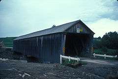
| 55 |
US Post Office-Presque Isle Main |
Upload image |
000000001986-05-09-0000May 9, 1986
(#86001034) |
23 2nd St.
46°40′53″N 68°01′07″W / 46.681389°N 68.018611°W / 46.681389; -68.018611 (US Post Office-Presque Isle Main) |
Presque Isle |
|
| 56 |
Watson Settlement Bridge |
|
000000001970-02-16-0000February 16, 1970
(#70000039) |
2 miles southeast of Littleton over the Meduxnekeag River
46°12′36″N 67°48′03″W / 46.21°N 67.800833°W / 46.21; -67.800833 (Watson Settlement Bridge) |
Littleton |
|
| 57 |
White Memorial Building |
Upload image |
000000001980-01-15-0000January 15, 1980
(#80000376) |
109 Main St.
46°07′33″N 67°50′17″W / 46.125833°N 67.838056°W / 46.125833; -67.838056 (White Memorial Building) |
Houlton |
Houses the Aroostook County Art and Historical Museum
|
| 58 |
Benjamin C. Wilder House |
Upload image |
000000001987-06-12-0000June 12, 1987
(#87000946) |
1267 Main St.
46°47′20″N 68°09′21″W / 46.788848°N 68.155801°W / 46.788848; -68.155801 (Benjamin C. Wilder House) |
Washburn |
|


.jpg)


.jpg)